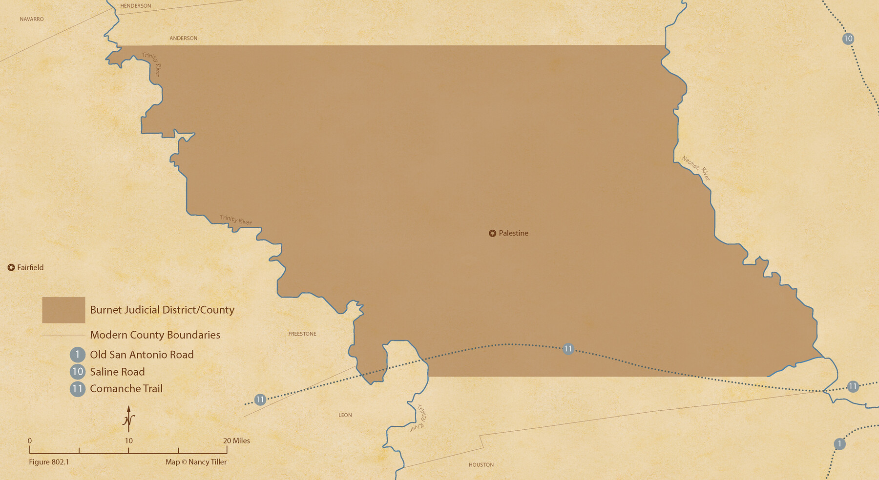
The Judicial District/County of Burnet. Created, January 30, 1841
Figure No. 802.1 from 'A Boundary Atlas of Texas, 1821-1845' by Jim Tiller
- 
                          Map/Doc
96322
 - 
                            Collection
Nancy and Jim Tiller Digital Collection
 - 
                            Object Dates
2020/1/1 (Creation Date)
 - 
                            People and Organizations
Jim Tiller (Author)
Nancy Tiller (Cartographer)
Gang Gong (GIS Professional)
 - 
                            Subjects
Atlas Republic of Texas Texas Boundaries
 - 
                            Height x Width
11.8 x 21.7 inches
30.0 x 55.1 cm
 - 
                            Medium
digital image
 - 
                            Comments
To purchase a digital PDF copy of "A Boundary Atlas of Texas, 1821-1845" see 96437.
 
Part of: Nancy and Jim Tiller Digital Collection
            The Republic County of San Patricio. Proposed, Late Fall 1837


                                            Print $20.00                    
                                    
                The Republic County of San Patricio. Proposed, Late Fall 1837
2020
Size 17.8 x 21.7 inches
                                Map/Doc 96273
            
            A Boundary Atlas of Texas, 1821-1845


                                                                    Digital $50.00                                    
                A Boundary Atlas of Texas, 1821-1845
2020
Map/Doc 96437
            
            The Republic County of Washington. January 29, 1842


                                            Print $20.00                    
                                    
                The Republic County of Washington. January 29, 1842
2020
Size 11.8 x 21.7 inches
                                Map/Doc 96307
            
            From Citizens of Southwestern Nacogdoches County for the Creation of a New Judicial County (Unnamed), Undated


                                            Print $20.00                    
                                    
                From Citizens of Southwestern Nacogdoches County for the Creation of a New Judicial County (Unnamed), Undated
2020
Size 19.9 x 21.7 inches
                                Map/Doc 96412
            
            The Republic County of Jefferson. January 29, 1842


                                            Print $20.00                    
                                    
                The Republic County of Jefferson. January 29, 1842
2020
Size 22.6 x 21.7 inches
                                Map/Doc 96199
            
            The Republic County of Austin. January 10, 1839


                                            Print $20.00                    
                                    
                The Republic County of Austin. January 10, 1839
2020
Size 7.0 x 22.0 inches
                                Map/Doc 96083
            
            From Citizens of Nacogdoches County to Redefine the Boundaries of Nacogdoches County, December 2, 1841


                                            Print $20.00                    
                                    
                From Citizens of Nacogdoches County to Redefine the Boundaries of Nacogdoches County, December 2, 1841
2020
Size 22.5 x 21.7 inches
                                Map/Doc 96395
            
            The Republic County of Nacogdoches. December 29, 1845


                                            Print $20.00                    
                                    
                The Republic County of Nacogdoches. December 29, 1845
2020
Size 15.9 x 21.8 inches
                                Map/Doc 96250
            
            The Republic County of Montgomery. Spring 1842


                                            Print $20.00                    
                                    
                The Republic County of Montgomery. Spring 1842
2020
Size 19.9 x 21.7 inches
                                Map/Doc 96240
            
            The Republic County of Colorado. Spring 1842


                                            Print $20.00                    
                                    
                The Republic County of Colorado. Spring 1842
2020
Size 18.4 x 21.7 inches
                                Map/Doc 96126
            
            The Republic County of Jasper. December 29, 1845


                                            Print $20.00                    
                                    
                The Republic County of Jasper. December 29, 1845
2020
Size 19.5 x 21.7 inches
                                Map/Doc 96196
            
            The Republic County of Milam. January 29, 1842


                                            Print $20.00                    
                                    
                The Republic County of Milam. January 29, 1842
2020
Size 17.4 x 21.6 inches
                                Map/Doc 96231
            You may also like
            Map of Texas comprising the grant of the Texian Emigration and Land-Company


                                            Print $20.00                    
                                             -                         Digital $50.00                                    
                Map of Texas comprising the grant of the Texian Emigration and Land-Company
1843
Size 9.4 x 10.1 inches
                                Map/Doc 94049
            
            Coke County Sketch File 17-18


                                            Print $24.00                    
                                             -                         Digital $50.00                                    
                Coke County Sketch File 17-18
1902
Size 16.6 x 14.2 inches
                                Map/Doc 11109
            
            Runnels County Rolled Sketch 47


                                            Print $40.00                    
                                             -                         Digital $50.00                                    
                Runnels County Rolled Sketch 47
1954
Size 49.9 x 30.5 inches
                                Map/Doc 76167
            
            No. 3 Chart of Channel connecting Corpus Christi Bay with Aransas Bay, Texas


                                            Print $20.00                    
                                             -                         Digital $50.00                                    
                No. 3 Chart of Channel connecting Corpus Christi Bay with Aransas Bay, Texas
1878
Size 18.3 x 27.9 inches
                                Map/Doc 72783
            
            Presidio County


                                            Print $40.00                    
                                             -                         Digital $50.00                                    
                Presidio County
1875
Size 97.8 x 33.5 inches
                                Map/Doc 88867
            
            Kerr County Working Sketch 27


                                            Print $20.00                    
                                             -                         Digital $50.00                                    
                Kerr County Working Sketch 27
1970
Size 25.4 x 20.8 inches
                                Map/Doc 70058
            
            Blanco County Sketch File 32


                                            Print $4.00                    
                                             -                         Digital $50.00                                    
                Blanco County Sketch File 32
1888
Size 8.5 x 11.1 inches
                                Map/Doc 14633
            
            Liberty County Working Sketch 50


                                            Print $20.00                    
                                             -                         Digital $50.00                                    
                Liberty County Working Sketch 50
1955
Size 22.4 x 33.5 inches
                                Map/Doc 70510
            
            Map of Jasper County


                                            Print $40.00                    
                                             -                         Digital $50.00                                    
                Map of Jasper County
1898
Size 49.1 x 39.6 inches
                                Map/Doc 66879
            
            Lubbock County Sketch File 11


                                            Print $22.00                    
                                             -                         Digital $50.00                                    
                Lubbock County Sketch File 11
1914
Size 11.2 x 8.8 inches
                                Map/Doc 30434
            
            Brewster County Working Sketch 117


                                            Print $20.00                    
                                             -                         Digital $50.00                                    
                Brewster County Working Sketch 117
1988
Size 33.3 x 37.0 inches
                                Map/Doc 67717
            
            United States - Gulf Coast - From Latitude 26° 33' to the Rio Grande Texas


                                            Print $20.00                    
                                             -                         Digital $50.00                                    
                United States - Gulf Coast - From Latitude 26° 33' to the Rio Grande Texas
1918
Size 27.6 x 18.1 inches
                                Map/Doc 72849