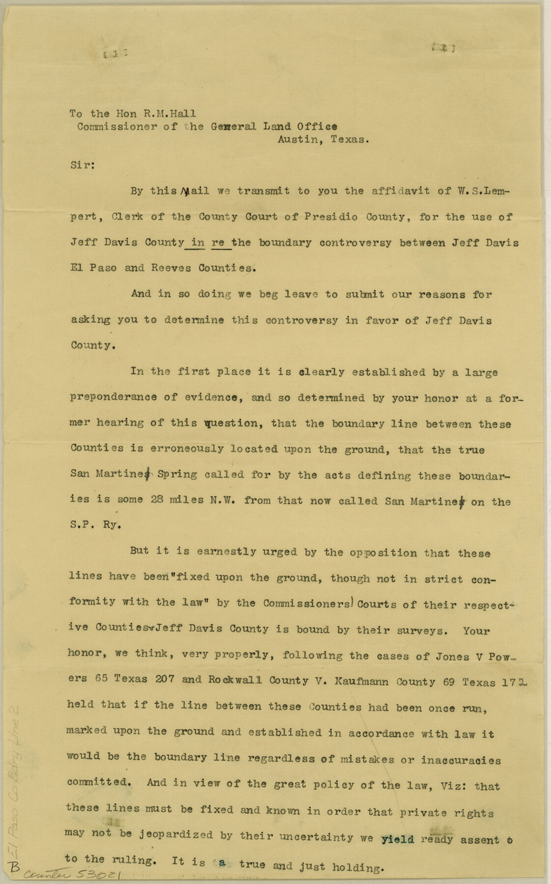
El Paso County Boundary File 2
[Court Order regarding the Boundary line between El Paso and Presidio Counties]
-
Map/Doc
53021
-
Collection
General Map Collection
-
Counties
El Paso
-
Subjects
County Boundaries
-
Height x Width
13.2 x 8.2 inches
33.5 x 20.8 cm
Part of: General Map Collection
Public Land on Mustang Island, Nueces County

Print $20.00
- Digital $50.00
Public Land on Mustang Island, Nueces County
1945
Size 43.4 x 40.1 inches
Map/Doc 73335
Moore County Rolled Sketch 13
Print $20.00
- Digital $50.00
Moore County Rolled Sketch 13
1920
Size 25.8 x 33.3 inches
Map/Doc 6829
Map of Padre Island Showing Location of Zoning Districts

Print $20.00
- Digital $50.00
Map of Padre Island Showing Location of Zoning Districts
1971
Size 18.5 x 26.4 inches
Map/Doc 4812
Rockport Quadrangle

Print $20.00
- Digital $50.00
Rockport Quadrangle
1954
Size 21.3 x 18.3 inches
Map/Doc 73435
Orange County Sketch File B

Print $20.00
- Digital $50.00
Orange County Sketch File B
1890
Size 17.6 x 26.0 inches
Map/Doc 12130
Polk County Boundary File 70

Print $12.00
- Digital $50.00
Polk County Boundary File 70
Size 8.2 x 3.6 inches
Map/Doc 57930
Liberty County Working Sketch 61

Print $20.00
- Digital $50.00
Liberty County Working Sketch 61
1969
Size 43.3 x 32.0 inches
Map/Doc 70521
Map of Asylum Lands

Print $20.00
- Digital $50.00
Map of Asylum Lands
1857
Size 22.0 x 29.1 inches
Map/Doc 2214
Lubbock County Sketch File 15

Print $6.00
- Digital $50.00
Lubbock County Sketch File 15
1902
Size 11.2 x 8.8 inches
Map/Doc 30440
Galveston County Rolled Sketch 9

Print $20.00
- Digital $50.00
Galveston County Rolled Sketch 9
1905
Size 45.2 x 37.2 inches
Map/Doc 9090
Marion County

Print $20.00
- Digital $50.00
Marion County
1943
Size 30.3 x 47.9 inches
Map/Doc 95579
Crosby County Sketch File 22

Print $22.00
- Digital $50.00
Crosby County Sketch File 22
1912
Size 11.3 x 8.6 inches
Map/Doc 20090
You may also like
Deaf Smith County Rolled Sketch 4

Print $20.00
- Digital $50.00
Deaf Smith County Rolled Sketch 4
Size 23.9 x 18.0 inches
Map/Doc 96789
Blanco County Rolled Sketch 8

Print $20.00
- Digital $50.00
Blanco County Rolled Sketch 8
Size 19.1 x 27.7 inches
Map/Doc 5145
[Blocks B16, B7, B15]
![93130, [Blocks B16, B7, B15], Twichell Survey Records](https://historictexasmaps.com/wmedia_w700/maps/93130-1.tif.jpg)
Print $40.00
- Digital $50.00
[Blocks B16, B7, B15]
Size 57.2 x 51.5 inches
Map/Doc 93130
Map of Winkler County

Print $20.00
- Digital $50.00
Map of Winkler County
1900
Size 42.4 x 38.6 inches
Map/Doc 16931
Oyster Creek, Texas showing connection with Brazos River & Oyster Bay by the Galveston & Brazos Canal for a Light Draft Navigation

Print $40.00
- Digital $50.00
Oyster Creek, Texas showing connection with Brazos River & Oyster Bay by the Galveston & Brazos Canal for a Light Draft Navigation
Size 18.0 x 52.9 inches
Map/Doc 96562
Presidio County Rolled Sketch 131A

Print $40.00
- Digital $50.00
Presidio County Rolled Sketch 131A
1991
Size 37.6 x 49.7 inches
Map/Doc 10713
Frio County Rolled Sketch 3

Print $20.00
- Digital $50.00
Frio County Rolled Sketch 3
Size 30.7 x 20.1 inches
Map/Doc 5916
Motley County Sketch File 3A (N)

Print $20.00
- Digital $50.00
Motley County Sketch File 3A (N)
Size 12.3 x 17.5 inches
Map/Doc 42136
Bexar County Working Sketch 14

Print $20.00
- Digital $50.00
Bexar County Working Sketch 14
1971
Size 35.2 x 37.7 inches
Map/Doc 67330
Bandera County Sketch File 24

Print $4.00
- Digital $50.00
Bandera County Sketch File 24
Size 9.3 x 8.3 inches
Map/Doc 14014
Lee County Boundary File 2

Print $25.00
- Digital $50.00
Lee County Boundary File 2
Size 14.2 x 8.6 inches
Map/Doc 56269