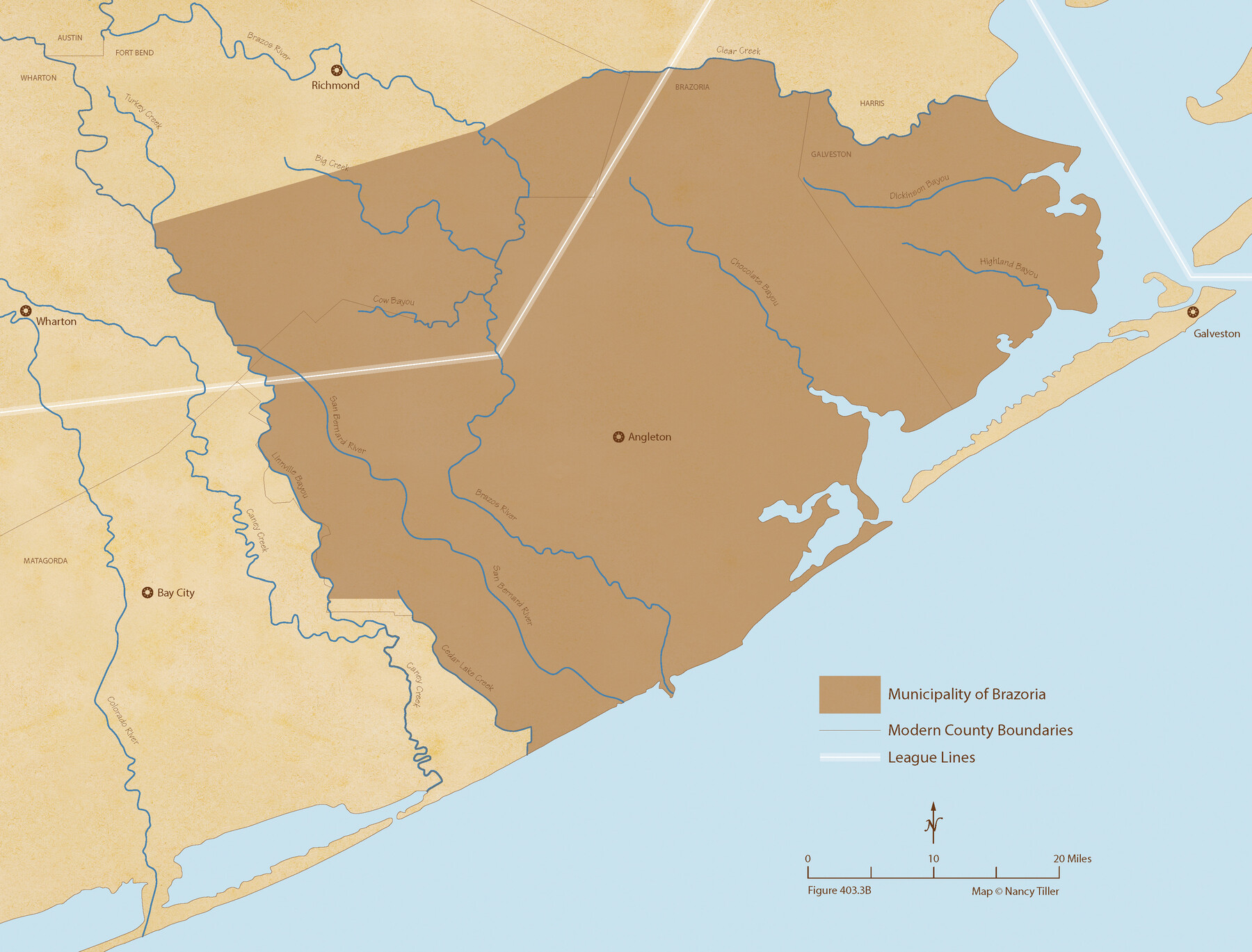
The Mexican Municipality of Brazoria. December 28, 1834
Figure No. 403.3 from 'A Boundary Atlas of Texas, 1821-1845' by Jim Tiller
-
Map/Doc
96017
-
Collection
Nancy and Jim Tiller Digital Collection
-
Object Dates
2020/1/1 (Creation Date)
-
People and Organizations
Jim Tiller (Author)
Nancy Tiller (Cartographer)
Gang Gong (GIS Professional)
-
Subjects
Atlas Mexican Texas Texas Boundaries
-
Height x Width
16.5 x 21.7 inches
41.9 x 55.1 cm
-
Medium
digital image
-
Comments
To purchase a digital PDF copy of "A Boundary Atlas of Texas, 1821-1845" see 96437.
Part of: Nancy and Jim Tiller Digital Collection
The Chief Justice County of Brazoria. April 24, 1837

Print $20.00
The Chief Justice County of Brazoria. April 24, 1837
2020
Size 14.8 x 21.7 inches
Map/Doc 96042
The Republic County of Fayette. May 24, 1838

Print $20.00
The Republic County of Fayette. May 24, 1838
2020
Size 14.7 x 21.7 inches
Map/Doc 96133
The Republic County of Brazos. December 29, 1845

Print $20.00
The Republic County of Brazos. December 29, 1845
2020
Size 20.6 x 21.7 inches
Map/Doc 96117
From Citizens of Montgomery County to Redefine the Boundary Between Harris and Montgomery Counties, May 8, 1838

Print $20.00
From Citizens of Montgomery County to Redefine the Boundary Between Harris and Montgomery Counties, May 8, 1838
2020
Size 15.4 x 21.7 inches
Map/Doc 96382
de Leon Empresario Colony. April 15, 1824

Print $20.00
de Leon Empresario Colony. April 15, 1824
2020
Size 18.5 x 21.7 inches
Map/Doc 95988
The Republic County of Harris. Proposed, Late Fall 1837

Print $20.00
The Republic County of Harris. Proposed, Late Fall 1837
2020
Size 17.7 x 21.7 inches
Map/Doc 96161
The Land Offices. No. 1, Red River, December 22, 1836

Print $20.00
The Land Offices. No. 1, Red River, December 22, 1836
2020
Size 13.7 x 21.7 inches
Map/Doc 96414
The Judicial District/County of Pashcal. June 24, 1841

Print $20.00
The Judicial District/County of Pashcal. June 24, 1841
2020
Size 15.0 x 21.7 inches
Map/Doc 96344
The Republic County of Brazoria. Proposed, Late Fall 1837-January 1, 1838

Print $20.00
The Republic County of Brazoria. Proposed, Late Fall 1837-January 1, 1838
2020
Size 13.0 x 21.7 inches
Map/Doc 96110
The Judicial District/County of Spring Creek. Created, January 21, 1841

Print $20.00
The Judicial District/County of Spring Creek. Created, January 21, 1841
2020
Size 15.7 x 21.7 inches
Map/Doc 96348
The Chief Justice County of Bexar. May 1, 1837

Print $20.00
The Chief Justice County of Bexar. May 1, 1837
2020
Size 25.4 x 21.6 inches
Map/Doc 96038
The Chief Justice County of Matagorda. March 30, 1837

Print $20.00
The Chief Justice County of Matagorda. March 30, 1837
2020
Size 19.7 x 21.7 inches
Map/Doc 96057
You may also like

Schleicher County Working Sketch Graphic Index

Print $40.00
- Digital $50.00
Schleicher County Working Sketch Graphic Index
1940
Size 37.8 x 54.2 inches
Map/Doc 76694
General Highway Map, Willacy County, Texas

Print $20.00
General Highway Map, Willacy County, Texas
1940
Size 18.5 x 24.8 inches
Map/Doc 79279
Presidio County Working Sketch Graphic Index, West Part, Sheet 1 (Sketches 1 to 74)

Print $20.00
- Digital $50.00
Presidio County Working Sketch Graphic Index, West Part, Sheet 1 (Sketches 1 to 74)
1974
Size 40.3 x 31.4 inches
Map/Doc 76672
Right of Way and Track Map, Houston & Texas Central R.R. operated by the T. and N. O. R.R., Fort Worth Branch

Print $40.00
- Digital $50.00
Right of Way and Track Map, Houston & Texas Central R.R. operated by the T. and N. O. R.R., Fort Worth Branch
1918
Size 30.9 x 56.9 inches
Map/Doc 64783
Dallas/Fort Worth Street Map & Visitor Guide

Dallas/Fort Worth Street Map & Visitor Guide
2000
Size 35.5 x 23.1 inches
Map/Doc 94296
Bee County Rolled Sketch 1

Print $20.00
- Digital $50.00
Bee County Rolled Sketch 1
2022
Size 24.4 x 36.0 inches
Map/Doc 97029
Presidio County Rolled Sketch 39

Print $20.00
- Digital $50.00
Presidio County Rolled Sketch 39
Size 16.0 x 22.0 inches
Map/Doc 7336
Kimble County Working Sketch 2

Print $20.00
- Digital $50.00
Kimble County Working Sketch 2
Size 20.6 x 17.9 inches
Map/Doc 70070
Jefferson County Working Sketch 22

Print $20.00
- Digital $50.00
Jefferson County Working Sketch 22
1969
Size 22.2 x 38.0 inches
Map/Doc 66565

Map of Wood County

Print $20.00
- Digital $50.00
Map of Wood County
1877
Size 16.8 x 17.1 inches
Map/Doc 4168