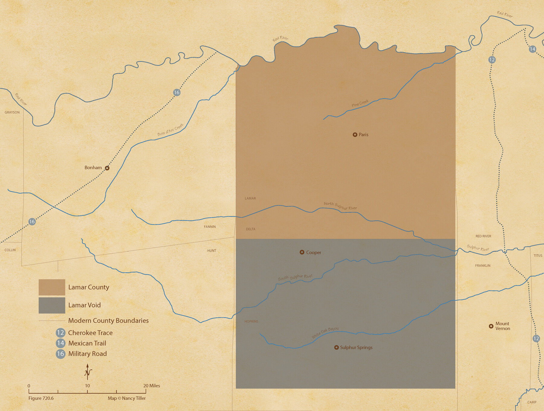
The Republic County of Lamar. December 29, 1845
Figure No. 720.6 from 'A Boundary Atlas of Texas, 1821-1845' by Jim Tiller
-
Map/Doc
96207
-
Collection
Nancy and Jim Tiller Digital Collection
-
Object Dates
2020/1/1 (Creation Date)
-
People and Organizations
Jim Tiller (Author)
Nancy Tiller (Cartographer)
Gang Gong (GIS Professional)
-
Counties
Lamar
-
Subjects
Atlas County Republic of Texas Texas Boundaries
-
Height x Width
16.4 x 21.7 inches
41.7 x 55.1 cm
-
Medium
digital image
-
Comments
To purchase a digital PDF copy of "A Boundary Atlas of Texas, 1821-1845" see 96437.
Part of: Nancy and Jim Tiller Digital Collection
The Mexican Municipality of Austin. Proposed, No Date

Print $20.00
The Mexican Municipality of Austin. Proposed, No Date
2020
Size 17.0 x 21.7 inches
Map/Doc 96014
The Judicial District/County of Burleson. Abolished, Spring 1842

Print $20.00
The Judicial District/County of Burleson. Abolished, Spring 1842
2020
Size 14.1 x 21.7 inches
Map/Doc 96321
The Republic County of Bastrop. January 25, 1840

Print $20.00
The Republic County of Bastrop. January 25, 1840
2020
Size 14.7 x 21.6 inches
Map/Doc 96091
From Citizens of Southwestern Nacogdoches County for the Creation of a New Judicial County (Unnamed), Undated

Print $20.00
From Citizens of Southwestern Nacogdoches County for the Creation of a New Judicial County (Unnamed), Undated
2020
Size 19.9 x 21.7 inches
Map/Doc 96412
From Citizens of Austin County Requesting to be Attached to Washington County, January 4, 1842

Print $20.00
From Citizens of Austin County Requesting to be Attached to Washington County, January 4, 1842
2020
Size 20.2 x 21.7 inches
Map/Doc 96396
The Empresario Grants. Arthur Goodall Wavell, Proposed Expansion

Print $20.00
The Empresario Grants. Arthur Goodall Wavell, Proposed Expansion
2020
Size 16.0 x 21.7 inches
Map/Doc 96427
From Citizens Living Between the Brazos and Trinity Rivers and Below the Old San Antonio Road in Montgomery and Washington Counties for the Creation of a New County to be Called Travis, Undated

Print $20.00
From Citizens Living Between the Brazos and Trinity Rivers and Below the Old San Antonio Road in Montgomery and Washington Counties for the Creation of a New County to be Called Travis, Undated
2020
Size 21.2 x 21.7 inches
Map/Doc 96401
The Chief Justice County of Gonzales. Lands in Conflict with Victoria County

Print $20.00
The Chief Justice County of Gonzales. Lands in Conflict with Victoria County
2020
Size 22.3 x 21.7 inches
Map/Doc 96048
The Republic County of Shelby. January 30, 1841

Print $20.00
The Republic County of Shelby. January 30, 1841
2020
Size 20.0 x 21.7 inches
Map/Doc 96282
The Republic County of Jackson. September 17, 1838

Print $20.00
The Republic County of Jackson. September 17, 1838
2020
Size 15.6 x 21.8 inches
Map/Doc 96185
The Republic County of Travis. January 29, 1842

Print $20.00
The Republic County of Travis. January 29, 1842
2020
Size 20.8 x 21.6 inches
Map/Doc 96291
The Mexican Municipality of Harrisburg. Defined, January 4, 1836

Print $20.00
The Mexican Municipality of Harrisburg. Defined, January 4, 1836
2020
Size 18.4 x 21.7 inches
Map/Doc 96022
You may also like
Copy of Surveyor's Field Book, Morris Browning - In Blocks 7, 5 & 4, I&GNRRCo., Hutchinson and Carson Counties, Texas

Print $2.00
- Digital $50.00
Copy of Surveyor's Field Book, Morris Browning - In Blocks 7, 5 & 4, I&GNRRCo., Hutchinson and Carson Counties, Texas
1888
Size 7.0 x 8.8 inches
Map/Doc 62267
Matagorda County Sketch File 42a

Print $18.00
- Digital $50.00
Matagorda County Sketch File 42a
1914
Size 11.2 x 8.6 inches
Map/Doc 30853
[Jas. T. Williams Survey]
![91260, [Jas. T. Williams Survey], Twichell Survey Records](https://historictexasmaps.com/wmedia_w700/maps/91260-1.tif.jpg)
Print $20.00
- Digital $50.00
[Jas. T. Williams Survey]
Size 24.0 x 18.4 inches
Map/Doc 91260
San Antonio - Places of Interest and how to get there

San Antonio - Places of Interest and how to get there
1920
Map/Doc 96785
Map of Lee County Texas

Print $20.00
- Digital $50.00
Map of Lee County Texas
1879
Size 26.2 x 18.0 inches
Map/Doc 4578
Map of the Cincinnati, New Orleans and Texas Pacific Ry and connections

Print $20.00
- Digital $50.00
Map of the Cincinnati, New Orleans and Texas Pacific Ry and connections
1889
Size 7.7 x 12.2 inches
Map/Doc 95758
Sketch of surveys in Houston Co. on Pine Bayou

Print $2.00
- Digital $50.00
Sketch of surveys in Houston Co. on Pine Bayou
Size 7.7 x 7.6 inches
Map/Doc 69742
Gulf of Mexico

Print $20.00
- Digital $50.00
Gulf of Mexico
1908
Size 18.2 x 27.2 inches
Map/Doc 72658
Gulf Intracoastal Waterway, Tex. - Aransas Bay to Corpus Christi Bay - Modified Route of Main Channel/Dredging

Print $20.00
- Digital $50.00
Gulf Intracoastal Waterway, Tex. - Aransas Bay to Corpus Christi Bay - Modified Route of Main Channel/Dredging
1958
Size 30.8 x 42.8 inches
Map/Doc 61896
Flight Mission No. BRE-2P, Frame 51, Nueces County

Print $20.00
- Digital $50.00
Flight Mission No. BRE-2P, Frame 51, Nueces County
1956
Size 18.6 x 22.7 inches
Map/Doc 86753
Reagan County Rolled Sketch 16

Print $20.00
- Digital $50.00
Reagan County Rolled Sketch 16
Size 25.6 x 47.5 inches
Map/Doc 9811
Location of the Southern Kansas Railway of Texas through Hemphill County, Texas

Print $40.00
- Digital $50.00
Location of the Southern Kansas Railway of Texas through Hemphill County, Texas
1887
Size 20.1 x 104.9 inches
Map/Doc 64034