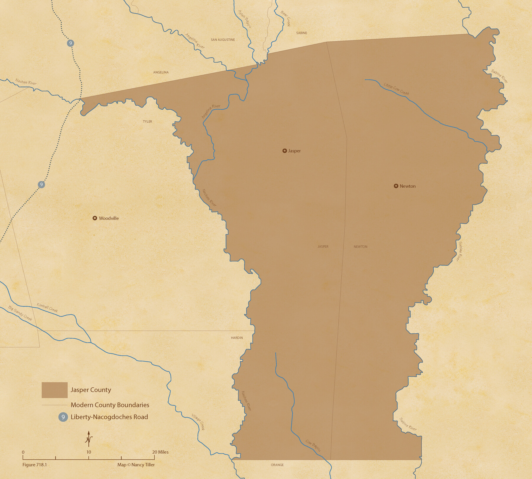
The Republic County of Jasper. Boundaries Defined, December 14, 1837
Figure No. 718.1 from 'A Boundary Atlas of Texas, 1821-1845' by Jim Tiller
-
Map/Doc
96193
-
Collection
Nancy and Jim Tiller Digital Collection
-
Object Dates
2020/1/1 (Creation Date)
-
People and Organizations
Jim Tiller (Author)
Nancy Tiller (Cartographer)
Gang Gong (GIS Professional)
-
Counties
Jasper
-
Subjects
Atlas County Republic of Texas Texas Boundaries
-
Height x Width
19.5 x 21.7 inches
49.5 x 55.1 cm
-
Medium
digital image
-
Comments
To purchase a digital PDF copy of "A Boundary Atlas of Texas, 1821-1845" see 96437.
Part of: Nancy and Jim Tiller Digital Collection
The Republic County of Rusk. December 31, 1844

Print $20.00
The Republic County of Rusk. December 31, 1844
2020
Size 19.1 x 21.7 inches
Map/Doc 96266
From Citizens of Montgomery County for the Creation of a New County to be Called Bowie, January 18, 1838

Print $20.00
From Citizens of Montgomery County for the Creation of a New County to be Called Bowie, January 18, 1838
2020
Size 19.1 x 21.7 inches
Map/Doc 96376
Republic Counties. January 1, 1842

Print $20.00
Republic Counties. January 1, 1842
2020
Size 24.5 x 21.7 inches
Map/Doc 96315
The Republic County of Matagorda. Proposed, Late Fall 1837

Print $20.00
The Republic County of Matagorda. Proposed, Late Fall 1837
2020
Size 21.0 x 21.7 inches
Map/Doc 96214
The Republic County of Galveston. January 20, 1841

Print $20.00
The Republic County of Galveston. January 20, 1841
2020
Size 14.7 x 21.9 inches
Map/Doc 96145
The Chief Justice County of Sabine. Undated

Print $20.00
The Chief Justice County of Sabine. Undated
2020
Size 20.0 x 21.7 inches
Map/Doc 96068
The Mexican Municipality of Jefferson. Defined, December 9, 1835

Print $20.00
The Mexican Municipality of Jefferson. Defined, December 9, 1835
2020
Size 15.5 x 21.7 inches
Map/Doc 96024
The Land Offices. No. 7, Milam, December 22, 1836

Print $20.00
The Land Offices. No. 7, Milam, December 22, 1836
2020
Size 23.9 x 21.7 inches
Map/Doc 96420
The Republic County of Nacogdoches. Proposed, Late Fall 1837

Print $20.00
The Republic County of Nacogdoches. Proposed, Late Fall 1837
2020
Size 17.5 x 21.7 inches
Map/Doc 96242
Refinement of the Line by County Surveyors from Gonzales and Victoria Counties, April 14, 1838

Print $20.00
Refinement of the Line by County Surveyors from Gonzales and Victoria Counties, April 14, 1838
2020
Size 24.9 x 21.7 inches
Map/Doc 96379
From Citizens of Gonzales County for the Creation of a New Judicial County (Unnamed), December 14, 1841

Print $20.00
From Citizens of Gonzales County for the Creation of a New Judicial County (Unnamed), December 14, 1841
2020
Size 24.1 x 21.7 inches
Map/Doc 96410
The Republic County of Harrison. January 30, 1841

Print $20.00
The Republic County of Harrison. January 30, 1841
2020
Size 18.8 x 21.7 inches
Map/Doc 96170
You may also like
Gulf Oil Corp. Fishgide - Port O'Connor

Gulf Oil Corp. Fishgide - Port O'Connor
1960
Size 12.0 x 22.0 inches
Map/Doc 75982
[Gulf Coast of Texas]
![72704, [Gulf Coast of Texas], General Map Collection](https://historictexasmaps.com/wmedia_w700/maps/72704.tif.jpg)
Print $20.00
- Digital $50.00
[Gulf Coast of Texas]
1881
Size 28.7 x 18.2 inches
Map/Doc 72704
Palo Pinto County Sketch File 23

Print $20.00
- Digital $50.00
Palo Pinto County Sketch File 23
1949
Size 23.5 x 15.4 inches
Map/Doc 12135
Live Oak County Sketch File 7

Print $4.00
- Digital $50.00
Live Oak County Sketch File 7
1875
Size 8.8 x 8.3 inches
Map/Doc 30259
Edwards County Working Sketch 97

Print $20.00
- Digital $50.00
Edwards County Working Sketch 97
1969
Size 25.5 x 27.6 inches
Map/Doc 68973
Map of the State of Texas engraved to illustrate Mitchell's school and family geography

Print $20.00
- Digital $50.00
Map of the State of Texas engraved to illustrate Mitchell's school and family geography
1846
Size 11.8 x 9.5 inches
Map/Doc 93498
Glasscock County Working Sketch 9

Print $40.00
- Digital $50.00
Glasscock County Working Sketch 9
1957
Size 77.9 x 25.5 inches
Map/Doc 63182
H No. 4 - Horn Island Pass, Mississippi Sound

Print $20.00
- Digital $50.00
H No. 4 - Horn Island Pass, Mississippi Sound
1852
Size 14.9 x 19.0 inches
Map/Doc 97225
Leon County Boundary File 1

Print $34.00
- Digital $50.00
Leon County Boundary File 1
Size 21.0 x 6.6 inches
Map/Doc 56281
Val Verde County Sketch File Z12

Print $4.00
- Digital $50.00
Val Verde County Sketch File Z12
1898
Size 11.4 x 8.8 inches
Map/Doc 39140
Mills County Boundary File 2

Print $6.00
- Digital $50.00
Mills County Boundary File 2
Size 14.1 x 8.7 inches
Map/Doc 57278
Presidio County Sketch File 116

Print $86.00
- Digital $50.00
Presidio County Sketch File 116
1993
Size 11.4 x 8.7 inches
Map/Doc 34842