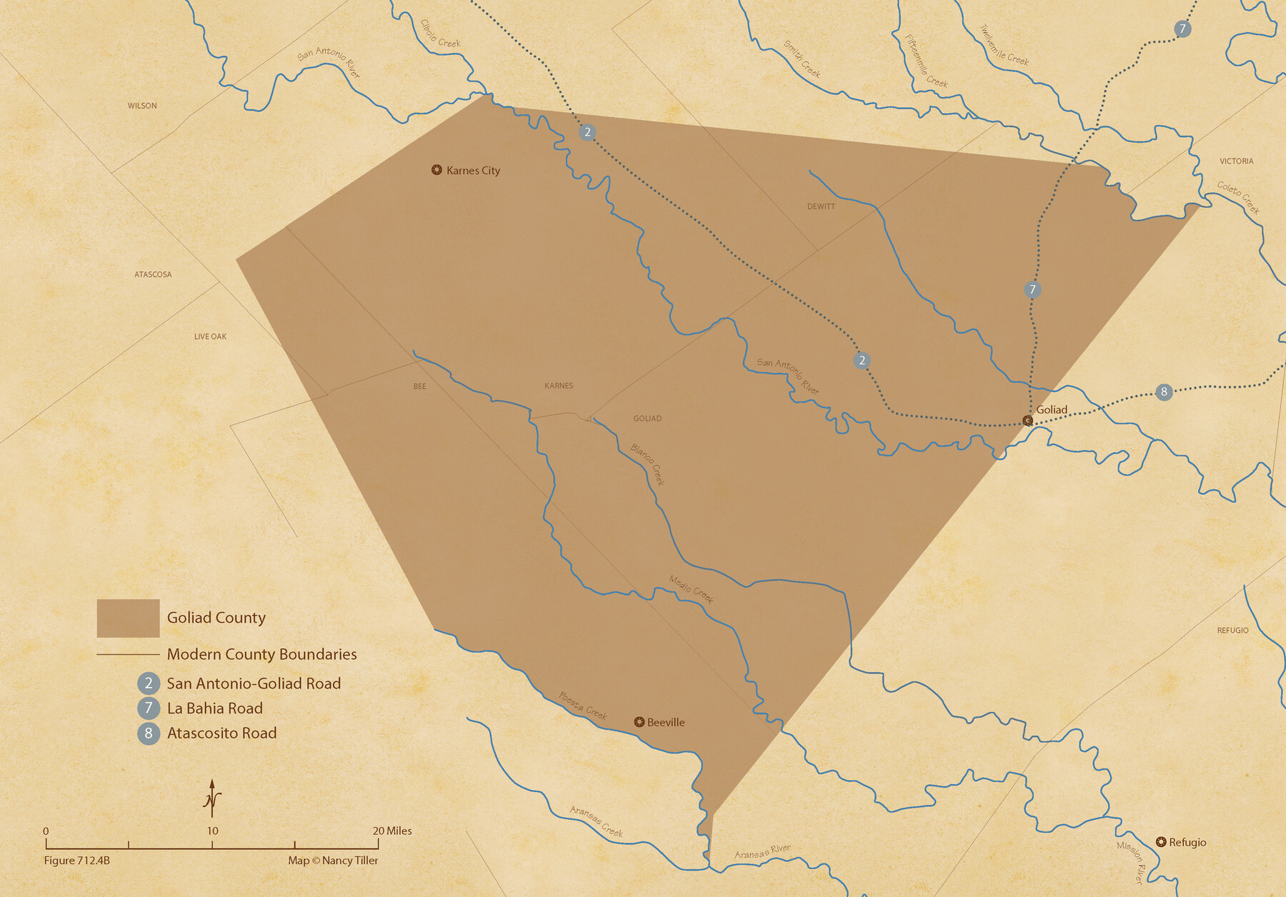
The Republic County of Goliad. 1840
Figure No. 712.4 from 'A Boundary Atlas of Texas, 1821-1845' by Jim Tiller
-
Map/Doc
96150
-
Collection
Nancy and Jim Tiller Digital Collection
-
Object Dates
2020/1/1 (Creation Date)
-
People and Organizations
Jim Tiller (Author)
Nancy Tiller (Cartographer)
Gang Gong (GIS Professional)
-
Counties
Goliad
-
Subjects
Atlas County Republic of Texas Texas Boundaries
-
Height x Width
15.1 x 21.7 inches
38.4 x 55.1 cm
-
Medium
digital image
-
Comments
To purchase a digital PDF copy of "A Boundary Atlas of Texas, 1821-1845" see 96437.
Part of: Nancy and Jim Tiller Digital Collection
The Mexican Municipality of Matagorda. Created, March 6, 1834

Print $20.00
The Mexican Municipality of Matagorda. Created, March 6, 1834
2020
Size 15.9 x 21.7 inches
Map/Doc 96025
The Republic County of Brazoria. December 16, 1839

Print $20.00
The Republic County of Brazoria. December 16, 1839
2020
Size 14.7 x 21.8 inches
Map/Doc 96113
Republic Counties. December 29, 1845

Print $20.00
Republic Counties. December 29, 1845
2020
Size 24.5 x 21.7 inches
Map/Doc 96319
The Republic County of Gonzales. May 24, 1838

Print $20.00
The Republic County of Gonzales. May 24, 1838
2020
Size 14.7 x 21.7 inches
Map/Doc 96156
The Republic County of Bowie. Created, December 17, 1840

Print $20.00
The Republic County of Bowie. Created, December 17, 1840
2020
Size 19.5 x 21.7 inches
Map/Doc 96102
The Chief Justice County of Jasper. April 21, 1837

Print $20.00
The Chief Justice County of Jasper. April 21, 1837
2020
Size 18.3 x 21.7 inches
Map/Doc 96052
The Republic County of Galveston. January 20, 1841

Print $20.00
The Republic County of Galveston. January 20, 1841
2020
Size 14.7 x 21.9 inches
Map/Doc 96145
The Republic County of Harris. May 15, 1838

Print $20.00
The Republic County of Harris. May 15, 1838
2020
Size 17.7 x 21.7 inches
Map/Doc 96163
From Citizens of Shelby County for the Creation of a New County to be Called Caddo, April 7, 1838

Print $20.00
From Citizens of Shelby County for the Creation of a New County to be Called Caddo, April 7, 1838
2020
Size 25.5 x 21.7 inches
Map/Doc 96377
Austin Empresario Colony. April 27, 1825

Print $20.00
Austin Empresario Colony. April 27, 1825
2020
Size 18.1 x 21.6 inches
Map/Doc 95979
The Republic County of Milam. Spring 1842

Print $20.00
The Republic County of Milam. Spring 1842
2020
Size 17.4 x 21.6 inches
Map/Doc 96232
The Republic County of Bexar. December 31, 1838

Print $20.00
The Republic County of Bexar. December 31, 1838
2020
Size 24.6 x 21.6 inches
Map/Doc 96096
You may also like
Johnson County Sketch File 24

Print $4.00
- Digital $50.00
Johnson County Sketch File 24
1873
Size 9.9 x 7.9 inches
Map/Doc 28457
Dimmit County Sketch File 12

Print $104.00
- Digital $50.00
Dimmit County Sketch File 12
1883
Size 31.9 x 33.6 inches
Map/Doc 10366
Map of the British Isles designed to accompany Smith's Geography for Schools

Print $20.00
- Digital $50.00
Map of the British Isles designed to accompany Smith's Geography for Schools
1850
Size 12.1 x 9.8 inches
Map/Doc 93894
Upton County Working Sketch Graphic Index, Sheet 1 (Sketches 1 to 39)

Print $40.00
- Digital $50.00
Upton County Working Sketch Graphic Index, Sheet 1 (Sketches 1 to 39)
1969
Size 49.9 x 37.0 inches
Map/Doc 76721
Harris County Working Sketch 90

Print $20.00
- Digital $50.00
Harris County Working Sketch 90
1973
Size 46.4 x 38.6 inches
Map/Doc 65982
Anderson County Boundary File 1

Print $10.00
- Digital $50.00
Anderson County Boundary File 1
Size 14.2 x 8.6 inches
Map/Doc 49726
Hansford County Working Sketch Graphic Index

Print $20.00
- Digital $50.00
Hansford County Working Sketch Graphic Index
1932
Size 39.2 x 38.2 inches
Map/Doc 76565
Texas Official Travel Map

Digital $50.00
Texas Official Travel Map
Size 33.3 x 36.2 inches
Map/Doc 94302
King County Sketch File 2

Print $4.00
- Digital $50.00
King County Sketch File 2
1882
Size 13.2 x 9.2 inches
Map/Doc 29020
Montague County Working Sketch 23

Print $20.00
- Digital $50.00
Montague County Working Sketch 23
1953
Size 31.2 x 27.5 inches
Map/Doc 71089
[Surveys in Austin's Colony along the Brazos River]
![213, [Surveys in Austin's Colony along the Brazos River], General Map Collection](https://historictexasmaps.com/wmedia_w700/maps/213.tif.jpg)
Print $20.00
- Digital $50.00
[Surveys in Austin's Colony along the Brazos River]
1824
Size 12.9 x 14.5 inches
Map/Doc 213
Flight Mission No. BRE-2P, Frame 47, Nueces County

Print $20.00
- Digital $50.00
Flight Mission No. BRE-2P, Frame 47, Nueces County
1956
Size 18.6 x 22.6 inches
Map/Doc 86749