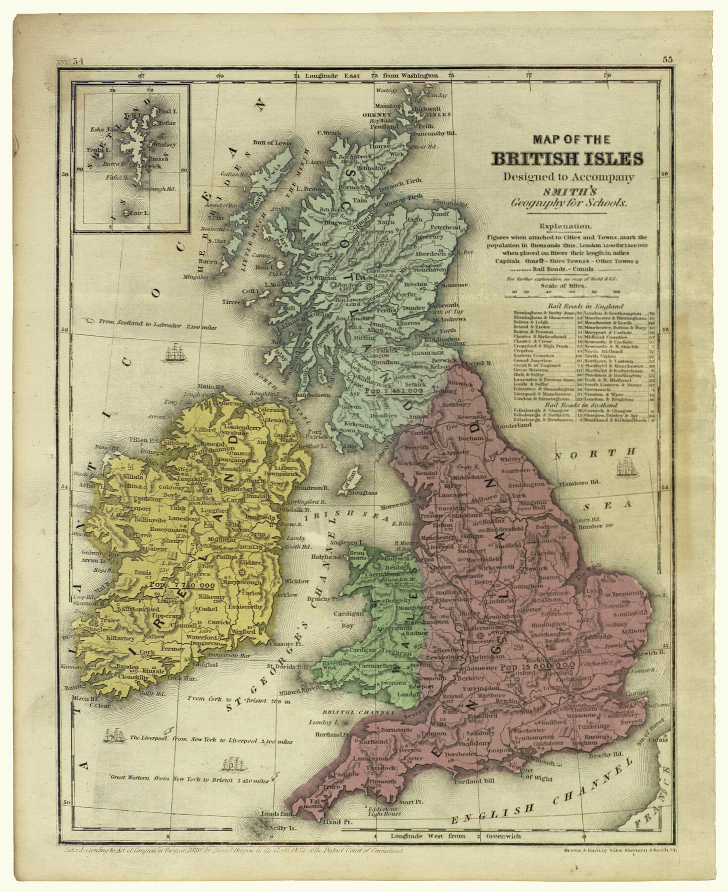
Map of the British Isles designed to accompany Smith's Geography for Schools
-
Map/Doc
93894
-
Collection
Holcomb Digital Map Collection
-
Object Dates
1850 (Creation Date)
-
People and Organizations
Stiles, Sherman and Smith (Printer)
Stiles, Sherman and Smith (Draftsman)
-
Subjects
Atlas Europe
-
Height x Width
12.1 x 9.8 inches
30.7 x 24.9 cm
-
Comments
Courtesy of Frank and Carol Holcomb.
Part of: Holcomb Digital Map Collection
Smith's Atlas designed to accompany the Geography

Print $352.00
- Digital $50.00
Smith's Atlas designed to accompany the Geography
1850
Size 12.2 x 10.0 inches
Map/Doc 93881
North America corrected from the observations communicated to the Royal Society at London and the Royal Academy at Paris

Print $20.00
- Digital $50.00
North America corrected from the observations communicated to the Royal Society at London and the Royal Academy at Paris
1710
Size 38.9 x 26.9 inches
Map/Doc 93820
Map of Texas shewing the grants in possession of the Colorado & Red River Land Compy

Print $20.00
- Digital $50.00
Map of Texas shewing the grants in possession of the Colorado & Red River Land Compy
1835
Size 20.3 x 26.9 inches
Map/Doc 93850
The History of Texas; or, the Emigrants, Farmer's, and Politician's Guide to the Character, Climate, Soil and Productions of that Country; geographically arranged from personal observation and experience.

Print $692.00
- Digital $50.00
The History of Texas; or, the Emigrants, Farmer's, and Politician's Guide to the Character, Climate, Soil and Productions of that Country; geographically arranged from personal observation and experience.
1836
Size 8.1 x 5.3 inches
Map/Doc 93856
Trace d'une partie Chemin de Fer de Galveston à Houston et Henderson, Texas, Etats unis d'Amérique

Print $20.00
- Digital $50.00
Trace d'une partie Chemin de Fer de Galveston à Houston et Henderson, Texas, Etats unis d'Amérique
1857
Size 17.1 x 21.8 inches
Map/Doc 93905
Map of the State of Texas from the Latest Authorities

Print $20.00
- Digital $50.00
Map of the State of Texas from the Latest Authorities
1854
Size 13.1 x 16.1 inches
Map/Doc 93901

Map of Texas containing the latest Grants and Discoveries

Print $20.00
- Digital $50.00
Map of Texas containing the latest Grants and Discoveries
1836
Size 12.7 x 9.1 inches
Map/Doc 93855
La Riviere de Missisipi, et ses environs, dans l'Amerique Septentrionale

Print $20.00
- Digital $50.00
La Riviere de Missisipi, et ses environs, dans l'Amerique Septentrionale
1715
Size 22.0 x 27.8 inches
Map/Doc 96518
Qvarte Partie Dv Monde

Print $20.00
- Digital $50.00
Qvarte Partie Dv Monde
1575
Size 15.3 x 18.9 inches
Map/Doc 93806
Carte Generale du Royaume de la Nouvelle Espagne depuis le Parallele de 16° jusqu'au Parallele de 38° (Latitude Nord)

Print $20.00
- Digital $50.00
Carte Generale du Royaume de la Nouvelle Espagne depuis le Parallele de 16° jusqu'au Parallele de 38° (Latitude Nord)
1804
Size 41.5 x 29.5 inches
Map/Doc 96510
A new & correct map of Texas compiled from the most recent surveys & authorities to the year 1845

Print $20.00
- Digital $50.00
A new & correct map of Texas compiled from the most recent surveys & authorities to the year 1845
1845
Size 22.4 x 28.5 inches
Map/Doc 96973
You may also like
Harris County Rolled Sketch 7b

Print $20.00
- Digital $50.00
Harris County Rolled Sketch 7b
Size 47.8 x 42.4 inches
Map/Doc 9853
Galveston County NRC Article 33.136 Sketch 59

Print $24.00
- Digital $50.00
Galveston County NRC Article 33.136 Sketch 59
2008
Size 11.5 x 17.0 inches
Map/Doc 94606
Ellis County Working Sketch 2

Print $20.00
- Digital $50.00
Ellis County Working Sketch 2
1947
Size 27.0 x 25.6 inches
Map/Doc 69018
Right-of-Way and Track Map, Houston and Brazos Valley Ry. Co. operated by the Houston and Brazos Valley Ry. Co.

Print $40.00
- Digital $50.00
Right-of-Way and Track Map, Houston and Brazos Valley Ry. Co. operated by the Houston and Brazos Valley Ry. Co.
1918
Size 24.9 x 56.6 inches
Map/Doc 64606
Hopkins County Sketch File 9

Print $6.00
- Digital $50.00
Hopkins County Sketch File 9
1856
Size 12.8 x 8.3 inches
Map/Doc 26697
Terrell County Rolled Sketch 31

Print $20.00
- Digital $50.00
Terrell County Rolled Sketch 31
1931
Size 24.4 x 28.4 inches
Map/Doc 7937
Subdivision of Alexander Ranch, Cochran County, Texas

Print $20.00
- Digital $50.00
Subdivision of Alexander Ranch, Cochran County, Texas
Size 15.4 x 29.8 inches
Map/Doc 92496
Flight Mission No. DCL-7C, Frame 108, Kenedy County

Print $20.00
- Digital $50.00
Flight Mission No. DCL-7C, Frame 108, Kenedy County
1943
Size 18.3 x 22.2 inches
Map/Doc 86073
Galveston County Sketch File 44

Print $20.00
- Digital $50.00
Galveston County Sketch File 44
1959
Size 25.2 x 38.8 inches
Map/Doc 10456
San Patricio County Aerial Photograph Index Sheet 5

Print $20.00
- Digital $50.00
San Patricio County Aerial Photograph Index Sheet 5
1957
Size 23.9 x 19.2 inches
Map/Doc 83747
Stonewall County Rolled Sketch 36B

Print $20.00
- Digital $50.00
Stonewall County Rolled Sketch 36B
Size 35.2 x 22.8 inches
Map/Doc 76404
Dickens County Sketch File 18

Print $6.00
- Digital $50.00
Dickens County Sketch File 18
1959
Size 11.3 x 8.8 inches
Map/Doc 20979