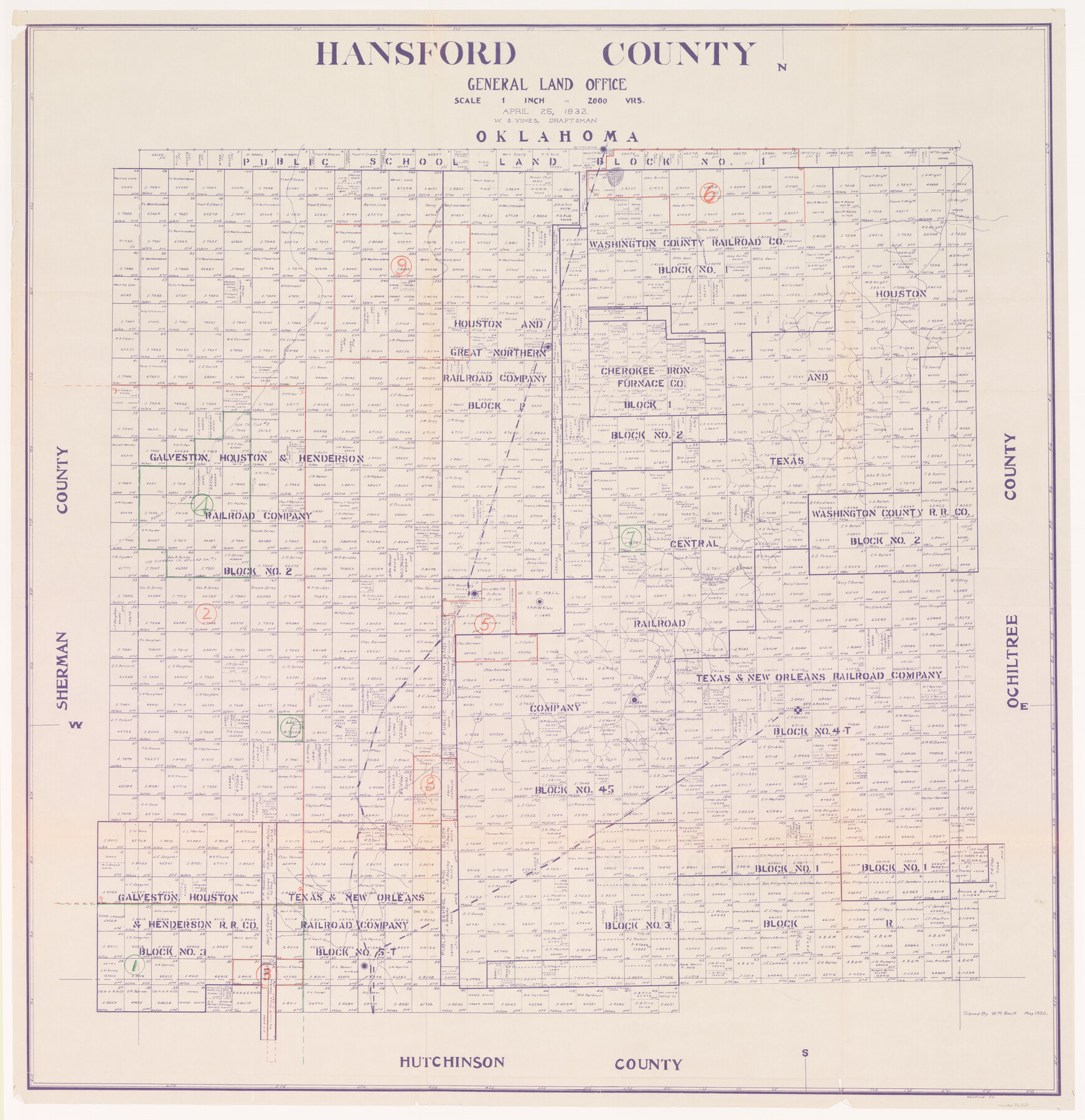
Hansford County Working Sketch Graphic Index
-
Map/Doc
76565
-
Collection
General Map Collection
-
Object Dates
4/25/1932 (Creation Date)
-
People and Organizations
W.S. Vines (Draftsman)
-
Counties
Hansford
-
Subjects
County Surveying Working Sketch
-
Height x Width
39.2 x 38.2 inches
99.6 x 97.0 cm
-
Scale
1" = 2000 varas
Part of: General Map Collection
Presidio County Rolled Sketch D

Print $20.00
- Digital $50.00
Presidio County Rolled Sketch D
Size 13.7 x 22.4 inches
Map/Doc 7408
Schleicher County Sketch File 6

Print $4.00
- Digital $50.00
Schleicher County Sketch File 6
Size 8.1 x 8.5 inches
Map/Doc 36472
Harris County Rolled Sketch 80

Print $20.00
- Digital $50.00
Harris County Rolled Sketch 80
1958
Size 31.1 x 31.0 inches
Map/Doc 6116
Township and Railroad Map of New Hampshire compiled from the best authorities with corrections and alteration of town lines from actual surveys

Print $20.00
- Digital $50.00
Township and Railroad Map of New Hampshire compiled from the best authorities with corrections and alteration of town lines from actual surveys
1854
Size 34.8 x 24.4 inches
Map/Doc 97105
Pecos County Working Sketch 32

Print $20.00
- Digital $50.00
Pecos County Working Sketch 32
1936
Size 21.8 x 22.2 inches
Map/Doc 71504
Runnels County Sketch File 10

Print $46.00
Runnels County Sketch File 10
1882
Size 7.3 x 8.2 inches
Map/Doc 35445
Van Zandt County Sketch File 16a

Print $4.00
- Digital $50.00
Van Zandt County Sketch File 16a
1858
Size 8.5 x 8.0 inches
Map/Doc 39412
Flight Mission No. BRA-6M, Frame 98, Jefferson County

Print $20.00
- Digital $50.00
Flight Mission No. BRA-6M, Frame 98, Jefferson County
1953
Size 18.5 x 22.2 inches
Map/Doc 85441
Howard County Working Sketch 2

Print $20.00
- Digital $50.00
Howard County Working Sketch 2
1903
Size 21.7 x 20.9 inches
Map/Doc 66268
Rusk County Sketch File 32

Print $20.00
Rusk County Sketch File 32
1949
Size 33.5 x 28.4 inches
Map/Doc 10596
Hardeman County Sketch File Y

Print $4.00
- Digital $50.00
Hardeman County Sketch File Y
Size 9.2 x 8.5 inches
Map/Doc 25054
Crockett County Rolled Sketch 46

Print $20.00
- Digital $50.00
Crockett County Rolled Sketch 46
1938
Size 46.0 x 43.0 inches
Map/Doc 8711
You may also like
Pecos County Working Sketch 36

Print $20.00
- Digital $50.00
Pecos County Working Sketch 36
1939
Size 47.4 x 38.8 inches
Map/Doc 71508
Bell County Sketch File 27

Print $4.00
- Digital $50.00
Bell County Sketch File 27
1870
Size 8.9 x 9.4 inches
Map/Doc 14435
Map of Chambers Co.

Print $20.00
- Digital $50.00
Map of Chambers Co.
1901
Size 24.9 x 25.1 inches
Map/Doc 4907
Hudspeth County Rolled Sketch 61

Print $40.00
- Digital $50.00
Hudspeth County Rolled Sketch 61
1982
Size 71.3 x 45.1 inches
Map/Doc 9626
English Field Notes of the Spanish Archives - Book SAW

English Field Notes of the Spanish Archives - Book SAW
1834
Map/Doc 96544
Map of Asia (Inset: Palestine)

Print $20.00
- Digital $50.00
Map of Asia (Inset: Palestine)
1844
Size 12.1 x 19.0 inches
Map/Doc 93548
Floyd County Sketch File 10

Print $12.00
- Digital $50.00
Floyd County Sketch File 10
1912
Size 11.6 x 8.9 inches
Map/Doc 22701
Webb County Sketch File 57

Print $20.00
- Digital $50.00
Webb County Sketch File 57
1942
Size 34.0 x 17.7 inches
Map/Doc 12652
Wood County Rolled Sketch 10

Print $20.00
- Digital $50.00
Wood County Rolled Sketch 10
Size 30.1 x 26.1 inches
Map/Doc 76416
Kimble County Sketch File 26

Print $4.00
- Digital $50.00
Kimble County Sketch File 26
1912
Size 7.8 x 13.0 inches
Map/Doc 28969
Dawson County

Print $20.00
- Digital $50.00
Dawson County
1959
Size 42.4 x 34.8 inches
Map/Doc 73127
Map of Comal County

Print $20.00
- Digital $50.00
Map of Comal County
1862
Size 18.6 x 22.0 inches
Map/Doc 3429