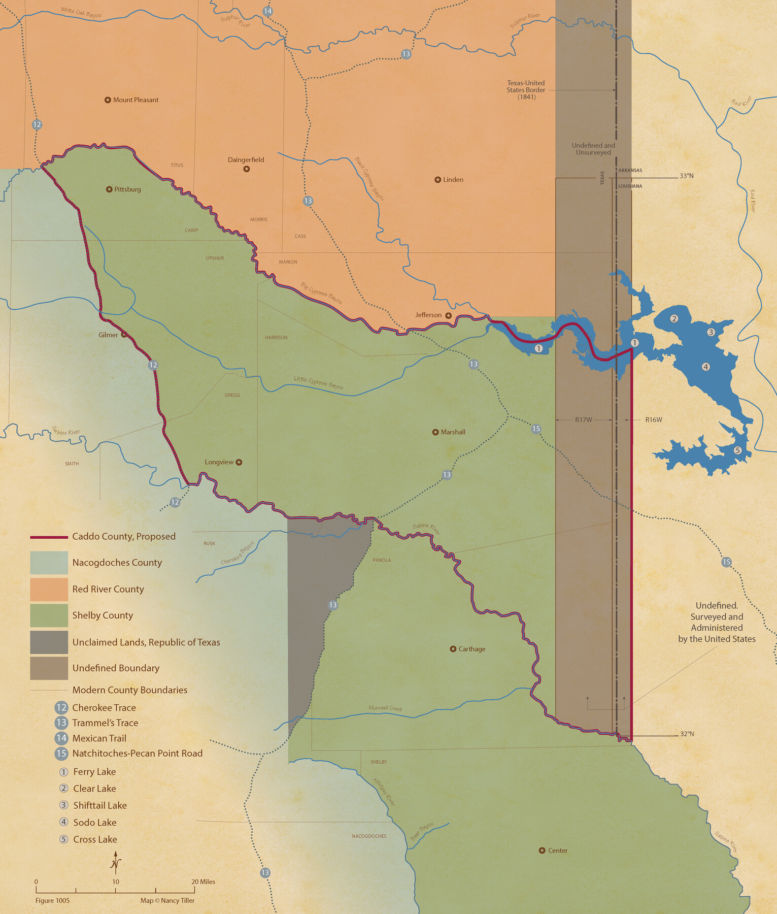
From Citizens of Shelby County for the Creation of a New County to be Called Caddo, April 7, 1838
Figure No. 1005 from 'A Boundary Atlas of Texas, 1821-1845' by Jim Tiller
-
Map/Doc
96377
-
Collection
Nancy and Jim Tiller Digital Collection
-
Object Dates
2020/1/1 (Creation Date)
-
People and Organizations
Jim Tiller (Author)
Nancy Tiller (Cartographer)
Gang Gong (GIS Professional)
-
Subjects
Atlas Republic of Texas Texas Boundaries
-
Height x Width
25.5 x 21.7 inches
64.8 x 55.1 cm
-
Medium
digital image
-
Comments
To purchase a digital PDF copy of "A Boundary Atlas of Texas, 1821-1845" see 96437.
Part of: Nancy and Jim Tiller Digital Collection
The Republic County of Shelby. January 28, 1839

Print $20.00
The Republic County of Shelby. January 28, 1839
2020
Size 21.1 x 21.7 inches
Map/Doc 96281
From Citizens of Montgomery County for the Creation of a New County to be Called Bowie, January 18, 1838

Print $20.00
From Citizens of Montgomery County for the Creation of a New County to be Called Bowie, January 18, 1838
2020
Size 19.1 x 21.7 inches
Map/Doc 96376
The Chief Justice County of San Augustine. Lands in Conflict with Sabine County

Print $20.00
The Chief Justice County of San Augustine. Lands in Conflict with Sabine County
2020
Size 14.6 x 21.7 inches
Map/Doc 96071
From Citizens of Red River County for the Creation of a New County to be Called Aurora, December 3, 1840

Print $20.00
From Citizens of Red River County for the Creation of a New County to be Called Aurora, December 3, 1840
2020
Size 19.8 x 21.7 inches
Map/Doc 96391
McMullen and McGloin Empresario Colony. August 16, 1828

Print $20.00
McMullen and McGloin Empresario Colony. August 16, 1828
2020
Size 17.6 x 21.7 inches
Map/Doc 95998
The Republic County of Brazoria. December 16, 1839

Print $20.00
The Republic County of Brazoria. December 16, 1839
2020
Size 14.7 x 21.8 inches
Map/Doc 96113
The Republic County of Colorado. Proposed, Late Fall 1837-January 1, 1838

Print $20.00
The Republic County of Colorado. Proposed, Late Fall 1837-January 1, 1838
2020
Size 18.4 x 21.7 inches
Map/Doc 96119
From Citizens of Shelby and Red River Counties Living East of the Sabine River and Southwest of the Sulphur Fork of Red River for the Creation of a New County to be Called Green, March 11, 1837/April 1, 1837

Print $20.00
From Citizens of Shelby and Red River Counties Living East of the Sabine River and Southwest of the Sulphur Fork of Red River for the Creation of a New County to be Called Green, March 11, 1837/April 1, 1837
2020
Size 24.3 x 21.7 inches
Map/Doc 96373
The Republic County of Gonzales. February 2, 1842

Print $20.00
The Republic County of Gonzales. February 2, 1842
2020
Size 14.7 x 21.7 inches
Map/Doc 96158
The Republic County of Lamar. December 29, 1845

Print $20.00
The Republic County of Lamar. December 29, 1845
2020
Size 16.4 x 21.7 inches
Map/Doc 96207
The Chief Justice County of Austin. Proposed, No Date

Print $20.00
The Chief Justice County of Austin. Proposed, No Date
2020
Size 16.7 x 21.7 inches
Map/Doc 96037
The Chief Justice County of Sabine. Lands in Conflict with Jasper and San Augustine Counties

Print $20.00
The Chief Justice County of Sabine. Lands in Conflict with Jasper and San Augustine Counties
2020
Size 20.0 x 21.7 inches
Map/Doc 96069
You may also like
Perspective Map of the City of Laredo

Print $20.00
- Digital $50.00
Perspective Map of the City of Laredo
1892
Size 24.2 x 36.3 inches
Map/Doc 97096
Map of Henderson County

Print $20.00
- Digital $50.00
Map of Henderson County
1871
Size 16.0 x 31.4 inches
Map/Doc 3665
Terrell County Rolled Sketch 47

Print $20.00
- Digital $50.00
Terrell County Rolled Sketch 47
1958
Size 20.0 x 18.4 inches
Map/Doc 7949
Hardin County Sketch File 47

Print $4.00
- Digital $50.00
Hardin County Sketch File 47
1875
Size 7.2 x 7.2 inches
Map/Doc 25200
Burnet County Working Sketch 5

Print $20.00
- Digital $50.00
Burnet County Working Sketch 5
1956
Size 30.0 x 19.3 inches
Map/Doc 67848
Arthur E. Miller Irrigated Farm West Half Section 19, Block D6

Print $20.00
- Digital $50.00
Arthur E. Miller Irrigated Farm West Half Section 19, Block D6
Size 11.9 x 21.8 inches
Map/Doc 92317

A Pocket Guide to Austin, Texas - Area Map and Downtown Map

A Pocket Guide to Austin, Texas - Area Map and Downtown Map
Size 17.0 x 20.1 inches
Map/Doc 94385
Kenedy County Aerial Photograph Index Sheet 5

Print $20.00
- Digital $50.00
Kenedy County Aerial Photograph Index Sheet 5
1943
Size 23.5 x 19.6 inches
Map/Doc 89046
Flight Mission No. DCL-7C, Frame 15, Kenedy County

Print $20.00
- Digital $50.00
Flight Mission No. DCL-7C, Frame 15, Kenedy County
1943
Size 15.4 x 15.3 inches
Map/Doc 86007
Marion County Working Sketch 41

Print $40.00
- Digital $50.00
Marion County Working Sketch 41
1996
Size 34.0 x 48.5 inches
Map/Doc 70817
Upper Galveston Bay, Houston Ship Channel, Dollar Pt. to Atkinson I.

Print $40.00
- Digital $50.00
Upper Galveston Bay, Houston Ship Channel, Dollar Pt. to Atkinson I.
1978
Size 49.3 x 36.8 inches
Map/Doc 69898