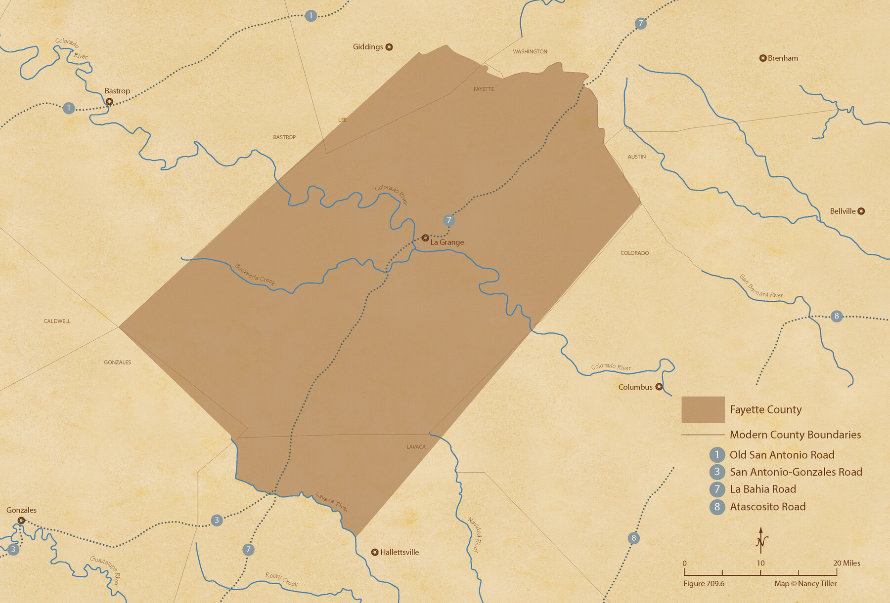
The Republic County of Fayette. December 29, 1845
Figure No. 709.6 from 'A Boundary Atlas of Texas, 1821-1845' by Jim Tiller
-
Map/Doc
96136
-
Collection
Nancy and Jim Tiller Digital Collection
-
Object Dates
2020/1/1 (Creation Date)
-
People and Organizations
Jim Tiller (Author)
Nancy Tiller (Cartographer)
Gang Gong (GIS Professional)
-
Counties
Fayette
-
Subjects
Atlas County Republic of Texas Texas Boundaries
-
Height x Width
14.7 x 21.7 inches
37.3 x 55.1 cm
-
Medium
digital image
-
Comments
To purchase a digital PDF copy of "A Boundary Atlas of Texas, 1821-1845" see 96437.
Part of: Nancy and Jim Tiller Digital Collection
Republic Counties. January 1, 1840

Print $20.00
Republic Counties. January 1, 1840
2020
Size 24.5 x 21.7 inches
Map/Doc 96313
The Republic County of Bexar. North View. Proposed, Fall 1837-December 31, 1838

Print $20.00
The Republic County of Bexar. North View. Proposed, Fall 1837-December 31, 1838
2020
Size 14.0 x 21.1 inches
Map/Doc 96094
The Republic County of Victoria. Boundaries Refined, January 25, 1841

Print $20.00
The Republic County of Victoria. Boundaries Refined, January 25, 1841
2020
Size 19.3 x 21.8 inches
Map/Doc 96297
The Republic County of Lamar. January 3, 1844

Print $20.00
The Republic County of Lamar. January 3, 1844
2020
Size 16.4 x 21.7 inches
Map/Doc 96206
The Fisher-Miller Colony. June 7, 1842

Print $20.00
The Fisher-Miller Colony. June 7, 1842
2020
Size 13.8 x 21.7 inches
Map/Doc 96358
The Land Offices. December 22, 1836

Print $20.00
The Land Offices. December 22, 1836
2020
Size 24.7 x 21.7 inches
Map/Doc 96425
The Judicial District/County of Pashcal. June 24, 1841

Print $20.00
The Judicial District/County of Pashcal. June 24, 1841
2020
Size 15.0 x 21.7 inches
Map/Doc 96344
The Republic County of Harris. January 25, 1840

Print $20.00
The Republic County of Harris. January 25, 1840
2020
Size 17.7 x 21.7 inches
Map/Doc 96165
The Judicial District/County of Hamilton. Created, February 2, 1842

Print $20.00
The Judicial District/County of Hamilton. Created, February 2, 1842
2020
Size 14.9 x 21.7 inches
Map/Doc 96329
The Republic County of Nacogdoches. December 6, 1841

Print $20.00
The Republic County of Nacogdoches. December 6, 1841
2020
Size 15.9 x 21.8 inches
Map/Doc 96246
The Republic County of Matagorda. Proposed, Late Fall 1837-January 1, 1838

Print $20.00
The Republic County of Matagorda. Proposed, Late Fall 1837-January 1, 1838
2020
Size 21.0 x 21.7 inches
Map/Doc 96215
The Republic County of Harrison. January 16, 1843

Print $20.00
The Republic County of Harrison. January 16, 1843
2020
Size 18.6 x 21.7 inches
Map/Doc 96174
You may also like
Gregg County Boundary File 6

Print $6.00
- Digital $50.00
Gregg County Boundary File 6
Size 8.5 x 5.8 inches
Map/Doc 54001

Reeves County Rolled Sketch 19

Print $20.00
- Digital $50.00
Reeves County Rolled Sketch 19
1969
Size 23.8 x 21.5 inches
Map/Doc 7488
San Jacinto County Working Sketch 29
Print $20.00
- Digital $50.00
San Jacinto County Working Sketch 29
1950
Size 17.6 x 24.4 inches
Map/Doc 63742
Shelby County Working Sketch 18

Print $20.00
- Digital $50.00
Shelby County Working Sketch 18
1957
Size 20.7 x 27.4 inches
Map/Doc 63871
Brewster County Rolled Sketch 122

Print $20.00
- Digital $50.00
Brewster County Rolled Sketch 122
1974
Size 33.4 x 24.8 inches
Map/Doc 5296
Finder Map of Greater San Antonio

Print $20.00
- Digital $50.00
Finder Map of Greater San Antonio
1950
Size 28.7 x 21.4 inches
Map/Doc 94029
Flight Mission No. CRC-3R, Frame 94, Chambers County

Print $20.00
- Digital $50.00
Flight Mission No. CRC-3R, Frame 94, Chambers County
1956
Size 18.5 x 22.3 inches
Map/Doc 84832
Township 11 South Range 13 West and 14 West, South Western District, Louisiana

Print $20.00
- Digital $50.00
Township 11 South Range 13 West and 14 West, South Western District, Louisiana
1838
Size 19.6 x 24.6 inches
Map/Doc 65854
Calhoun County Rolled Sketch 18

Print $20.00
- Digital $50.00
Calhoun County Rolled Sketch 18
1952
Size 12.2 x 11.9 inches
Map/Doc 5371
Morris County Rolled Sketch 2A

Print $20.00
- Digital $50.00
Morris County Rolled Sketch 2A
Size 22.5 x 17.6 inches
Map/Doc 10230
Shackelford County Rolled Sketch 5

Print $20.00
- Digital $50.00
Shackelford County Rolled Sketch 5
1984
Size 23.1 x 37.1 inches
Map/Doc 7773