Morris County Rolled Sketch 2A
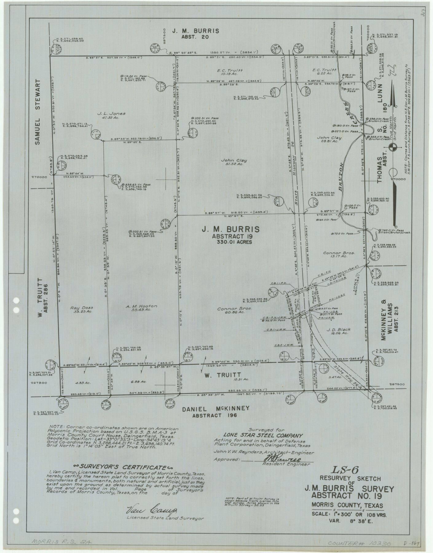
LS-6 - Resurvey sketch of J.M. Burris survey, abstract no. 19, Morris County, Texas
-
Map/Doc
10230
-
Collection
General Map Collection
-
People and Organizations
Van Camp (Surveyor/Engineer)
-
Counties
Morris
-
Subjects
Surveying Rolled Sketch
-
Height x Width
22.5 x 17.6 inches
57.2 x 44.7 cm
-
Medium
linen, manuscript
-
Scale
1" = 108 varas
-
Comments
See Morris County Rolled Sketch 2 (9550) for map of all retracement surveys made for Lone Star Steel Company.
Related maps
Morris County Rolled Sketch 2

Print $40.00
- Digital $50.00
Morris County Rolled Sketch 2
1944
Size 59.4 x 43.5 inches
Map/Doc 9550
Part of: General Map Collection
Cass County Working Sketch 27

Print $20.00
- Digital $50.00
Cass County Working Sketch 27
1978
Size 17.5 x 19.7 inches
Map/Doc 67930
McLennan County Sketch File 3

Print $4.00
- Digital $50.00
McLennan County Sketch File 3
1857
Size 11.1 x 8.1 inches
Map/Doc 31233
Presidio County Sketch File 102

Print $4.00
- Digital $50.00
Presidio County Sketch File 102
Size 11.3 x 8.8 inches
Map/Doc 34793
Taylor County Sketch File 9

Print $40.00
- Digital $50.00
Taylor County Sketch File 9
Size 14.6 x 15.8 inches
Map/Doc 37792
Webb County Sketch File 46

Print $20.00
- Digital $50.00
Webb County Sketch File 46
1879
Size 19.6 x 14.9 inches
Map/Doc 12644
Hansford County

Print $20.00
- Digital $50.00
Hansford County
1932
Size 39.7 x 39.0 inches
Map/Doc 95519
Dimmit County Working Sketch 23

Print $20.00
- Digital $50.00
Dimmit County Working Sketch 23
1954
Size 22.5 x 23.3 inches
Map/Doc 68684
Briscoe County Rolled Sketch 11A

Print $20.00
- Digital $50.00
Briscoe County Rolled Sketch 11A
1913
Size 11.7 x 12.3 inches
Map/Doc 5329

Chambers County Sketch File 54

Print $3.00
- Digital $50.00
Chambers County Sketch File 54
1895
Size 16.5 x 10.3 inches
Map/Doc 18093
Comanche County Sketch File 9

Print $4.00
- Digital $50.00
Comanche County Sketch File 9
1859
Size 6.0 x 9.1 inches
Map/Doc 19068
Bandera County Rolled Sketch 10

Print $20.00
- Digital $50.00
Bandera County Rolled Sketch 10
1998
Size 35.4 x 38.1 inches
Map/Doc 8440
You may also like
Goliad County Rolled Sketch 2

Print $20.00
- Digital $50.00
Goliad County Rolled Sketch 2
1944
Size 33.1 x 34.6 inches
Map/Doc 9010
Goliad County Sketch File 22

Print $12.00
- Digital $50.00
Goliad County Sketch File 22
1855
Size 12.8 x 8.1 inches
Map/Doc 24289
Nueces County Rolled Sketch 111

Print $20.00
- Digital $50.00
Nueces County Rolled Sketch 111
1991
Size 24.6 x 36.1 inches
Map/Doc 7119
Chapman and McFarlin Production Co. Cogdell Ranch Kent County, Texas

Print $2.00
- Digital $50.00
Chapman and McFarlin Production Co. Cogdell Ranch Kent County, Texas
1952
Size 9.0 x 8.9 inches
Map/Doc 92190

Denton County

Print $20.00
- Digital $50.00
Denton County
1947
Size 40.7 x 37.2 inches
Map/Doc 77262
Jasper County Working Sketch 35

Print $20.00
- Digital $50.00
Jasper County Working Sketch 35
2008
Size 28.5 x 40.0 inches
Map/Doc 88733
[Block O1, Godair]
![90566, [Block O1, Godair], Twichell Survey Records](https://historictexasmaps.com/wmedia_w700/maps/90566-1.tif.jpg)
Print $20.00
- Digital $50.00
[Block O1, Godair]
Size 22.7 x 18.0 inches
Map/Doc 90566
Hudspeth County Rolled Sketch 57

Print $20.00
- Digital $50.00
Hudspeth County Rolled Sketch 57
Size 38.3 x 46.0 inches
Map/Doc 9223
Kimble County Sketch File L1

Print $22.00
- Digital $50.00
Kimble County Sketch File L1
Size 7.1 x 13.1 inches
Map/Doc 28967
Anderson County Sketch File 3

Print $4.00
- Digital $50.00
Anderson County Sketch File 3
1856
Size 12.7 x 8.2 inches
Map/Doc 12741
Randall County Sketch File 6

Print $20.00
- Digital $50.00
Randall County Sketch File 6
Size 17.2 x 23.5 inches
Map/Doc 12208