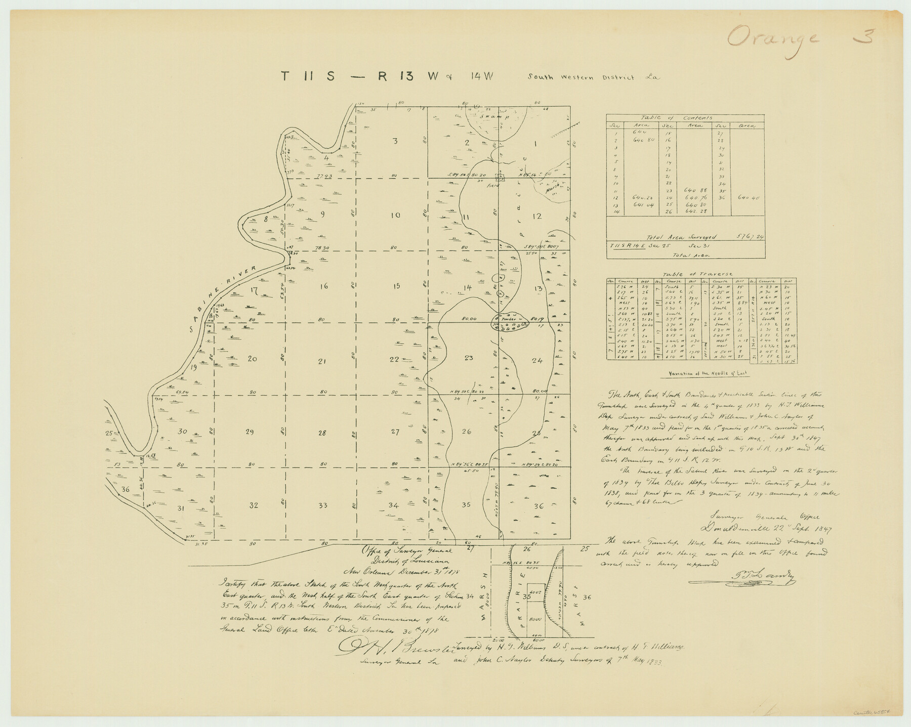
Township 11 South Range 13 West and 14 West, South Western District, Louisiana
Louisiana Land Surveys Across From Orange County, Texas 3
-
Map/Doc
65854
-
Collection
General Map Collection
-
Object Dates
1838/6/30 (Creation Date)
-
People and Organizations
Surveyor General's Office Louisiana (Publisher)
Thomas Bilbo (Surveyor/Engineer)
-
Subjects
Texas Boundaries
-
Height x Width
19.6 x 24.6 inches
49.8 x 62.5 cm
-
Comments
G. H. Brewster, Surveyor General Louisiana, approved copy dated December 31, 1878.
Part of: General Map Collection
Flight Mission No. CGI-1N, Frame 137, Cameron County

Print $20.00
- Digital $50.00
Flight Mission No. CGI-1N, Frame 137, Cameron County
1955
Size 15.5 x 18.8 inches
Map/Doc 84493
Collin County Working Sketch 1

Print $20.00
- Digital $50.00
Collin County Working Sketch 1
1921
Size 26.6 x 23.4 inches
Map/Doc 68095
Coleman County Working Sketch 9

Print $20.00
- Digital $50.00
Coleman County Working Sketch 9
1950
Size 24.9 x 30.5 inches
Map/Doc 68075

Dallam County Sketch File 12

Print $40.00
- Digital $50.00
Dallam County Sketch File 12
Size 50.0 x 9.1 inches
Map/Doc 10360
Texas Coordinate File 6

Print $40.00
- Digital $50.00
Texas Coordinate File 6
1946
Size 23.7 x 49.0 inches
Map/Doc 75314
Terrell County Working Sketch 56

Print $20.00
- Digital $50.00
Terrell County Working Sketch 56
Size 44.0 x 36.4 inches
Map/Doc 69577
Texas Official Travel Map

Digital $50.00
Texas Official Travel Map
Size 33.5 x 36.2 inches
Map/Doc 94303
Flight Mission No. CRC-3R, Frame 98, Chambers County

Print $20.00
- Digital $50.00
Flight Mission No. CRC-3R, Frame 98, Chambers County
1956
Size 18.7 x 22.5 inches
Map/Doc 84836
Flight Mission No. CRC-5R, Frame 34, Chambers County

Print $20.00
- Digital $50.00
Flight Mission No. CRC-5R, Frame 34, Chambers County
1956
Size 18.5 x 22.3 inches
Map/Doc 84953
Map of Hill County

Print $40.00
- Digital $50.00
Map of Hill County
1884
Size 80.1 x 68.0 inches
Map/Doc 82049
Tyler County Sketch File 4

Print $4.00
- Digital $50.00
Tyler County Sketch File 4
1857
Size 13.9 x 8.4 inches
Map/Doc 38628
You may also like
Shelby County Rolled Sketch 5

Print $20.00
- Digital $50.00
Shelby County Rolled Sketch 5
1942
Size 37.9 x 43.7 inches
Map/Doc 9921
Dawson County, Texas

Print $20.00
- Digital $50.00
Dawson County, Texas
Size 16.0 x 18.1 inches
Map/Doc 92620
Blanco County Sketch File 49

Print $12.00
- Digital $50.00
Blanco County Sketch File 49
Size 14.3 x 8.8 inches
Map/Doc 14691
Old Miscellaneous File 27b

Print $10.00
- Digital $50.00
Old Miscellaneous File 27b
1880
Size 14.3 x 8.8 inches
Map/Doc 75722
Coke County Working Sketch 26

Print $20.00
- Digital $50.00
Coke County Working Sketch 26
1961
Size 29.1 x 31.2 inches
Map/Doc 68063
Flight Mission No. DAG-21K, Frame 95, Matagorda County

Print $20.00
- Digital $50.00
Flight Mission No. DAG-21K, Frame 95, Matagorda County
1952
Size 18.6 x 22.2 inches
Map/Doc 86424
Cameron County Rolled Sketch 19

Print $20.00
- Digital $50.00
Cameron County Rolled Sketch 19
1937
Size 26.0 x 21.8 inches
Map/Doc 5470
Dallas County Boundary File 6b

Print $40.00
- Digital $50.00
Dallas County Boundary File 6b
Size 14.1 x 8.6 inches
Map/Doc 52207
Winkler County Working Sketch Graphic Index

Print $20.00
- Digital $50.00
Winkler County Working Sketch Graphic Index
1932
Size 36.4 x 36.4 inches
Map/Doc 76744
Webb County Sketch File 11

Print $18.00
- Digital $50.00
Webb County Sketch File 11
1883
Size 8.7 x 7.6 inches
Map/Doc 39770
Laguna Madre, T-9210

Print $20.00
- Digital $50.00
Laguna Madre, T-9210
Size 34.6 x 31.9 inches
Map/Doc 73601
Flight Mission No. CUG-3P, Frame 46, Kleberg County

Print $20.00
- Digital $50.00
Flight Mission No. CUG-3P, Frame 46, Kleberg County
1956
Size 18.5 x 22.2 inches
Map/Doc 86251