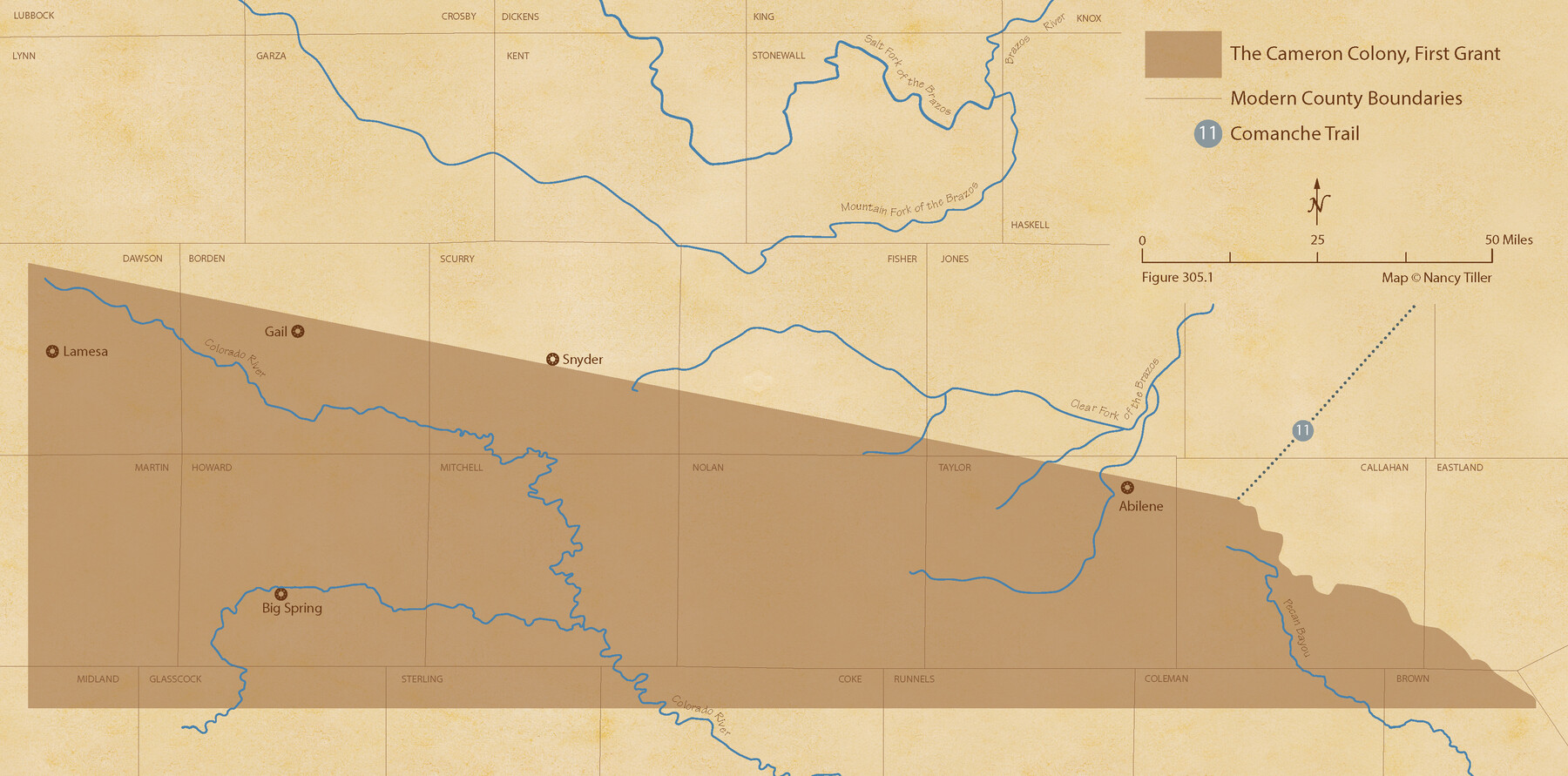
Cameron Empresario Colony. May 21, 1827
Figure No. 305.1 from 'A Boundary Atlas of Texas, 1821-1845' by Jim Tiller
-
Map/Doc
95986
-
Collection
Nancy and Jim Tiller Digital Collection
-
Object Dates
2020/1/1 (Creation Date)
-
People and Organizations
Jim Tiller (Author)
Nancy Tiller (Cartographer)
Gang Gong (GIS Professional)
-
Subjects
Atlas Colony Mexican Texas Texas Boundaries
-
Height x Width
10.7 x 21.7 inches
27.2 x 55.1 cm
-
Medium
digital image
-
Comments
To purchase a digital PDF copy of "A Boundary Atlas of Texas, 1821-1845" see 96437.
Part of: Nancy and Jim Tiller Digital Collection
The Republic County of Gonzales. December 29, 1845

Print $20.00
The Republic County of Gonzales. December 29, 1845
2020
Size 14.7 x 21.7 inches
Map/Doc 96160
The Judicial District/County of Waco. Abolished, Spring 1842

Print $20.00
The Judicial District/County of Waco. Abolished, Spring 1842
2020
Size 16.2 x 21.7 inches
Map/Doc 96353
From Citizens of Washington County Living East of the Brazos River and in the Forks of the Navasota and Brazos Rivers and South of the Old San Antonio Road for the Creation of a New County (Unnamed), January 13, 1840

Print $20.00
From Citizens of Washington County Living East of the Brazos River and in the Forks of the Navasota and Brazos Rivers and South of the Old San Antonio Road for the Creation of a New County (Unnamed), January 13, 1840
2020
Size 20.4 x 21.7 inches
Map/Doc 96388
The Republic County of Colorado. Spring 1842

Print $20.00
The Republic County of Colorado. Spring 1842
2020
Size 18.4 x 21.7 inches
Map/Doc 96126
From Citizens of Shelby County for the Creation of a New County (Unnamed), July 14, 1838

Print $20.00
From Citizens of Shelby County for the Creation of a New County (Unnamed), July 14, 1838
2020
Size 25.5 x 21.7 inches
Map/Doc 96383
Vehlein and Company Empresario Colony. November 17, 1828

Print $20.00
Vehlein and Company Empresario Colony. November 17, 1828
2020
Size 20.8 x 21.7 inches
Map/Doc 96008
The Republic County of Nacogdoches. November 28. 1839

Print $20.00
The Republic County of Nacogdoches. November 28. 1839
2020
Size 17.5 x 21.7 inches
Map/Doc 96245
The Judicial District/County of DeWitt. Created, February 2, 1842

Print $20.00
The Judicial District/County of DeWitt. Created, February 2, 1842
2020
Size 22.4 x 21.7 inches
Map/Doc 96325
The Republic County of Red River. December 29, 1845

Print $20.00
The Republic County of Red River. December 29, 1845
2020
Size 21.0 x 21.7 inches
Map/Doc 96255
Letter from Jesse Grimes Suggesting a Redefinition of the Boundary Between Harris and Montgomery Counties, April 30, 1838

Print $20.00
Letter from Jesse Grimes Suggesting a Redefinition of the Boundary Between Harris and Montgomery Counties, April 30, 1838
2020
Size 15.4 x 21.7 inches
Map/Doc 96381
The Peters Colony. January 29, 1844

Print $20.00
The Peters Colony. January 29, 1844
2020
Size 17.2 x 21.7 inches
Map/Doc 96366
The Chief Justice County of San Patricio. Lands in Conflict with Bexar County

Print $20.00
The Chief Justice County of San Patricio. Lands in Conflict with Bexar County
2020
Size 20.0 x 21.7 inches
Map/Doc 96073
You may also like
Parker County Sketch File 15A

Print $20.00
- Digital $50.00
Parker County Sketch File 15A
1875
Size 28.5 x 13.6 inches
Map/Doc 12144

Flight Mission No. CUG-2P, Frame 30, Kleberg County

Print $20.00
- Digital $50.00
Flight Mission No. CUG-2P, Frame 30, Kleberg County
1956
Size 18.5 x 22.4 inches
Map/Doc 86195
Edwards County Sketch File 18

Print $6.00
- Digital $50.00
Edwards County Sketch File 18
Size 16.3 x 10.6 inches
Map/Doc 21738
Hutchinson County Sketch File 46

Print $50.00
- Digital $50.00
Hutchinson County Sketch File 46
1981
Size 11.2 x 8.7 inches
Map/Doc 27365
Flight Mission No. CUG-1P, Frame 27, Kleberg County

Print $20.00
- Digital $50.00
Flight Mission No. CUG-1P, Frame 27, Kleberg County
1956
Size 18.4 x 22.1 inches
Map/Doc 86117

Presidio County Working Sketch 26

Print $20.00
- Digital $50.00
Presidio County Working Sketch 26
1945
Size 41.9 x 24.3 inches
Map/Doc 71702
Hays County Rolled Sketch 28

Print $20.00
- Digital $50.00
Hays County Rolled Sketch 28
1954
Size 20.2 x 37.5 inches
Map/Doc 6183
Armstrong County Working Sketch 3

Print $20.00
- Digital $50.00
Armstrong County Working Sketch 3
1904
Size 46.1 x 40.8 inches
Map/Doc 67234
Refugio County Sketch File 10

Print $4.00
- Digital $50.00
Refugio County Sketch File 10
Size 8.2 x 9.4 inches
Map/Doc 35258
Dallam County Sketch File 12

Print $40.00
- Digital $50.00
Dallam County Sketch File 12
Size 50.0 x 9.1 inches
Map/Doc 10360