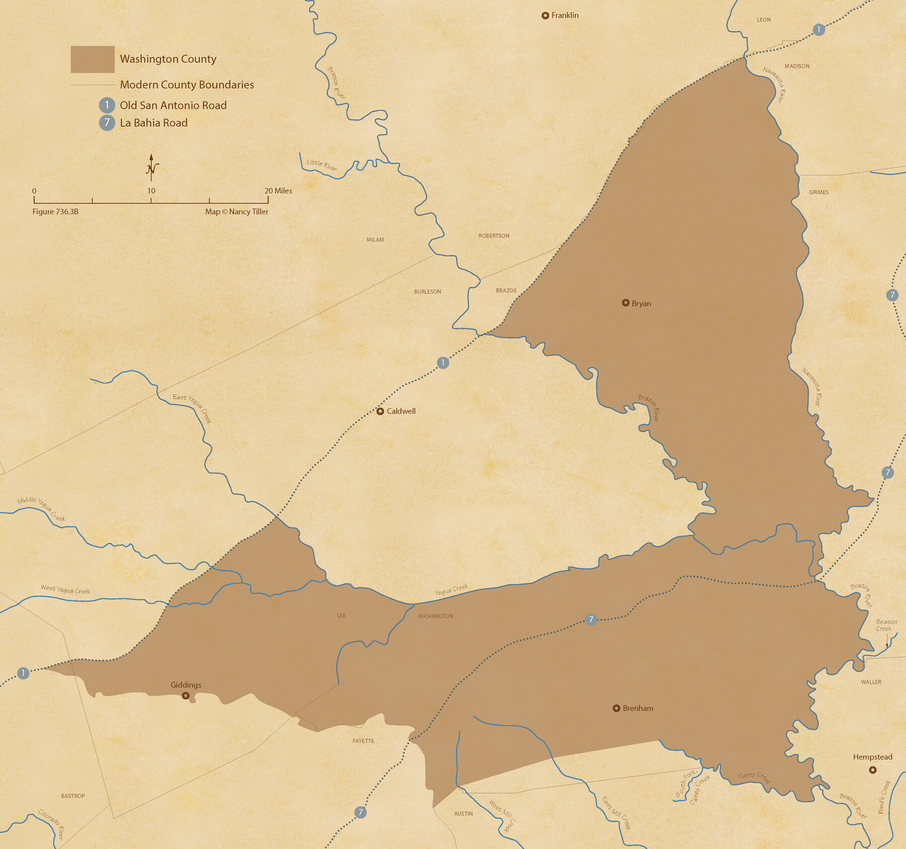
The Republic County of Washington. February 4, 1840
Figure No. 736.3 from 'A Boundary Atlas of Texas, 1821-1845' by Jim Tiller
-
Map/Doc
96304
-
Collection
Nancy and Jim Tiller Digital Collection
-
Object Dates
2020/1/1 (Creation Date)
-
People and Organizations
Jim Tiller (Author)
Nancy Tiller (Cartographer)
Gang Gong (GIS Professional)
-
Counties
Washington
-
Subjects
Atlas County Republic of Texas Texas Boundaries
-
Height x Width
20.3 x 21.7 inches
51.6 x 55.1 cm
-
Medium
digital image
-
Comments
To purchase a digital PDF copy of "A Boundary Atlas of Texas, 1821-1845" see 96437.
Part of: Nancy and Jim Tiller Digital Collection
The Republic County of Victoria. January 29, 1842

Print $20.00
The Republic County of Victoria. January 29, 1842
2020
Size 24.3 x 21.7 inches
Map/Doc 96298
The Judicial District/County of Madison. Abolished, Spring 1842

Print $20.00
The Judicial District/County of Madison. Abolished, Spring 1842
2020
Size 18.2 x 21.7 inches
Map/Doc 96334
The Chief Justice County of Milam. April 16, 1837

Print $20.00
The Chief Justice County of Milam. April 16, 1837
2020
Size 16.8 x 21.7 inches
Map/Doc 96059
Authors’ Interpretation of Figure A1029.1, Red River and Shelby Counties, Undated

Print $20.00
Authors’ Interpretation of Figure A1029.1, Red River and Shelby Counties, Undated
2020
Size 20.1 x 21.7 inches
Map/Doc 96404
From Citizens of Washington County Living East of the Brazos River and in the Forks of the Navasota and Brazos Rivers and South of the Old San Antonio Road for the Creation of a New County (Unnamed), January 13, 1840

Print $20.00
From Citizens of Washington County Living East of the Brazos River and in the Forks of the Navasota and Brazos Rivers and South of the Old San Antonio Road for the Creation of a New County (Unnamed), January 13, 1840
2020
Size 20.4 x 21.7 inches
Map/Doc 96388
The Chief Justice County of Bexar. Lands in Conflict with San Patricio County

Print $20.00
The Chief Justice County of Bexar. Lands in Conflict with San Patricio County
2020
Size 14.7 x 21.6 inches
Map/Doc 96040
The Republic County of Milam. November 28, 1839

Print $20.00
The Republic County of Milam. November 28, 1839
2020
Size 17.4 x 21.6 inches
Map/Doc 96228
The Chief Justice County of Sabine. Undated

Print $20.00
The Chief Justice County of Sabine. Undated
2020
Size 20.0 x 21.7 inches
Map/Doc 96068
The Republic County of Red River. January 28, 1841

Print $20.00
The Republic County of Red River. January 28, 1841
2020
Size 21.0 x 21.7 inches
Map/Doc 96253
The Republic County of Lamar. Created, December 17, 1840

Print $20.00
The Republic County of Lamar. Created, December 17, 1840
2020
Size 16.4 x 21.7 inches
Map/Doc 96202
The Mexican Municipality of Gonzales. April 1834

Print $20.00
The Mexican Municipality of Gonzales. April 1834
2020
Size 20.4 x 21.7 inches
Map/Doc 96021
The Republic County of Jasper. Boundaries Defined, December 14, 1837

Print $20.00
The Republic County of Jasper. Boundaries Defined, December 14, 1837
2020
Size 19.5 x 21.7 inches
Map/Doc 96193
You may also like
DeWitt County Sketch File 5

Print $4.00
- Digital $50.00
DeWitt County Sketch File 5
1872
Size 13.0 x 8.3 inches
Map/Doc 20803
San Augustine County Rolled Sketch 1

Print $20.00
- Digital $50.00
San Augustine County Rolled Sketch 1
1946
Size 19.1 x 30.4 inches
Map/Doc 7553
[Topographical Map showing part of Miller Day Ranch in Southwest Part of Coleman County]
![81515, [Topographical Map showing part of Miller Day Ranch in Southwest Part of Coleman County], General Map Collection](https://historictexasmaps.com/wmedia_w700/maps/81515.tif.jpg)
Print $3.00
- Digital $50.00
[Topographical Map showing part of Miller Day Ranch in Southwest Part of Coleman County]
Size 11.3 x 17.3 inches
Map/Doc 81515
Brazoria County Rolled Sketch 50A

Print $20.00
- Digital $50.00
Brazoria County Rolled Sketch 50A
1932
Size 17.8 x 26.1 inches
Map/Doc 5188
Robertson County Working Sketch 11

Print $20.00
- Digital $50.00
Robertson County Working Sketch 11
1984
Size 20.2 x 21.4 inches
Map/Doc 63584

Flight Mission No. BRA-8M, Frame 75, Jefferson County

Print $20.00
- Digital $50.00
Flight Mission No. BRA-8M, Frame 75, Jefferson County
1953
Size 18.6 x 22.4 inches
Map/Doc 85595
Presidio County Rolled Sketch A-2

Print $20.00
- Digital $50.00
Presidio County Rolled Sketch A-2
1889
Size 36.9 x 43.9 inches
Map/Doc 9770
Hudspeth County Rolled Sketch 60

Print $20.00
- Digital $50.00
Hudspeth County Rolled Sketch 60
1982
Size 43.4 x 44.4 inches
Map/Doc 9225
[McK. & Williams No. 601 and surrounding surveys, Travis County]
![75553, [McK. & Williams No. 601 and surrounding surveys, Travis County], Maddox Collection](https://historictexasmaps.com/wmedia_w700/maps/75553.tif.jpg)
Print $3.00
- Digital $50.00
[McK. & Williams No. 601 and surrounding surveys, Travis County]
Size 16.3 x 10.7 inches
Map/Doc 75553
Hale County Sketch File E

Print $20.00
- Digital $50.00
Hale County Sketch File E
1902
Size 15.2 x 21.5 inches
Map/Doc 11601
[Map of Hardin County]
![3630, [Map of Hardin County], General Map Collection](https://historictexasmaps.com/wmedia_w700/maps/3630-2.tif.jpg)
Print $20.00
- Digital $50.00
[Map of Hardin County]
1862
Size 18.0 x 22.0 inches
Map/Doc 3630