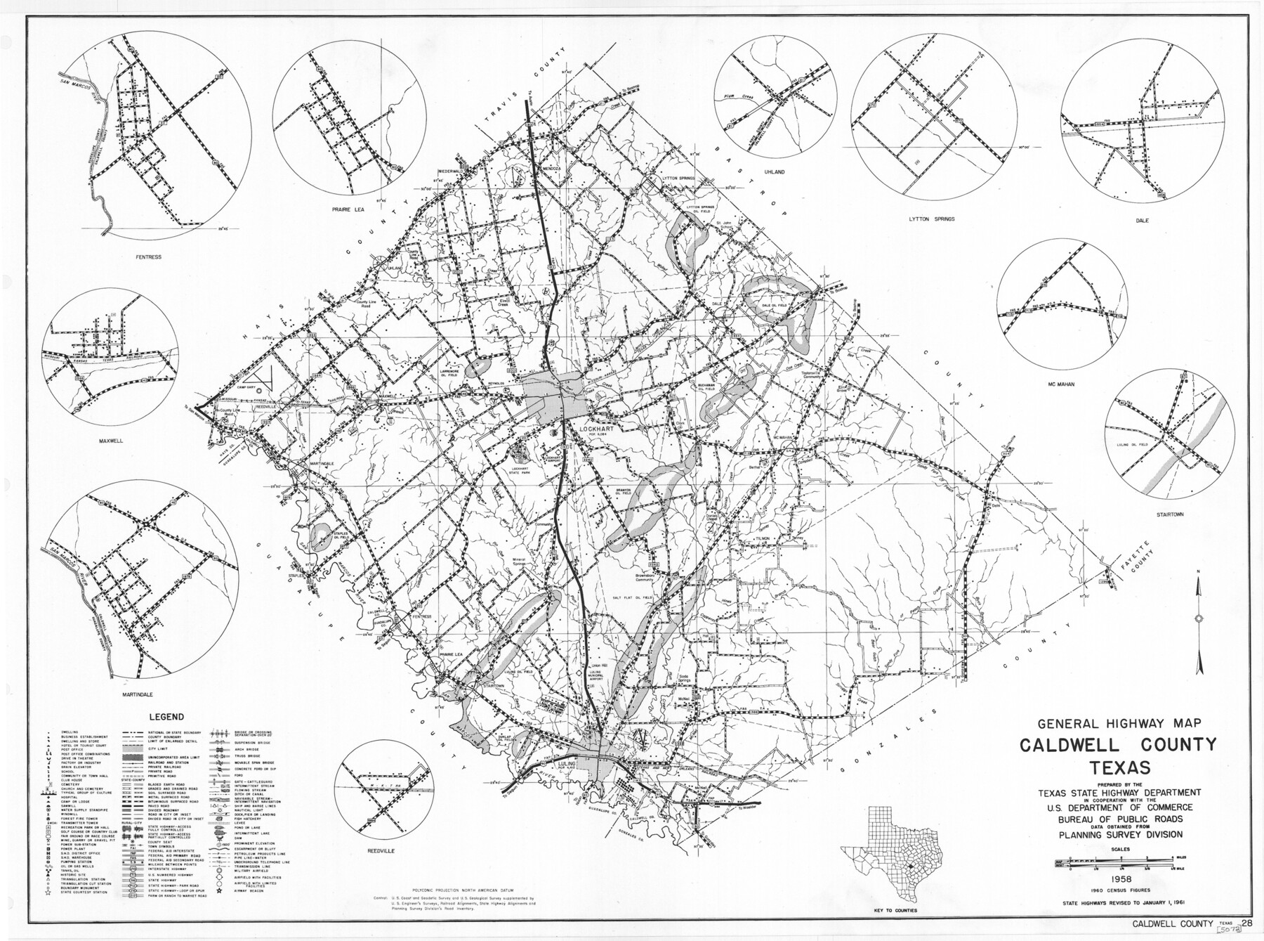
General Highway Map, Caldwell County, Texas
-
Map/Doc
79394
-
Collection
Texas State Library and Archives
-
Object Dates
1961 (Creation Date)
-
People and Organizations
Texas State Highway Department (Publisher)
-
Counties
Caldwell
-
Subjects
County
-
Height x Width
18.3 x 24.6 inches
46.5 x 62.5 cm
-
Comments
Prints available courtesy of the Texas State Library and Archives.
More info can be found here: TSLAC Map 05072
Part of: Texas State Library and Archives
General Highway Map, Goliad County, Texas

Print $20.00
General Highway Map, Goliad County, Texas
1961
Size 18.2 x 24.7 inches
Map/Doc 79481
Map of Texas Compiled from surveys recorded in the General Land Office

Print $20.00
Map of Texas Compiled from surveys recorded in the General Land Office
1851
Size 31.4 x 25.3 inches
Map/Doc 76209
General Highway Map, Brewster County, Texas

Print $20.00
General Highway Map, Brewster County, Texas
1940
Size 18.5 x 25.1 inches
Map/Doc 79028
General Highway Map, Kenedy County, Texas

Print $20.00
General Highway Map, Kenedy County, Texas
1961
Size 18.1 x 24.6 inches
Map/Doc 79447
General Highway Map, Borden County, Texas

Print $20.00
General Highway Map, Borden County, Texas
1940
Size 18.5 x 25.0 inches
Map/Doc 79021
General Highway Map, Cottle County, Texas

Print $20.00
General Highway Map, Cottle County, Texas
1940
Size 18.3 x 25.2 inches
Map/Doc 79060
General Highway Map, Henderson County, Texas

Print $20.00
General Highway Map, Henderson County, Texas
1961
Size 24.9 x 18.0 inches
Map/Doc 79517

Mapa de los Estados Unidos de Méjico, Segun lo organizado y definido por las varias actas del Congreso de dicha Republica: y construido por las mejores autoridades

Print $20.00
Mapa de los Estados Unidos de Méjico, Segun lo organizado y definido por las varias actas del Congreso de dicha Republica: y construido por las mejores autoridades
1828
Size 29.3 x 41.6 inches
Map/Doc 76217
Map of the City of Galveston, situated on the East End of Galveston Island, Texas

Print $20.00
Map of the City of Galveston, situated on the East End of Galveston Island, Texas
1869
Size 33.3 x 46.6 inches
Map/Doc 76186
Map of Texas to Accompany Granger's Southern and Western Texas Guide

Print $20.00
Map of Texas to Accompany Granger's Southern and Western Texas Guide
1878
Size 26.4 x 20.4 inches
Map/Doc 76235
General Highway Map, Starr County, Texas

Print $20.00
General Highway Map, Starr County, Texas
1961
Size 25.1 x 18.3 inches
Map/Doc 79659
You may also like
Flight Mission No. DQN-2K, Frame 9, Calhoun County

Print $20.00
- Digital $50.00
Flight Mission No. DQN-2K, Frame 9, Calhoun County
1953
Size 15.7 x 15.6 inches
Map/Doc 84226
Presidio County Sketch File 87

Print $6.00
- Digital $50.00
Presidio County Sketch File 87
1951
Size 14.5 x 8.7 inches
Map/Doc 34748
Calhoun County Sketch File 14

Print $20.00
- Digital $50.00
Calhoun County Sketch File 14
1852
Size 22.6 x 16.2 inches
Map/Doc 35980
Current Miscellaneous File 76

Print $10.00
- Digital $50.00
Current Miscellaneous File 76
1960
Size 11.3 x 8.8 inches
Map/Doc 74189
United States - Gulf Coast - Galveston to Rio Grande

Print $20.00
- Digital $50.00
United States - Gulf Coast - Galveston to Rio Grande
1941
Size 27.2 x 18.2 inches
Map/Doc 72753
Flight Mission No. DCL-7C, Frame 14, Kenedy County

Print $20.00
- Digital $50.00
Flight Mission No. DCL-7C, Frame 14, Kenedy County
1943
Size 15.3 x 15.2 inches
Map/Doc 86006
Spence Addition Owned by L.N. Goldbeck and Herman Pressler - A Subdivision of Outlot 43, Division "O"

Print $20.00
- Digital $50.00
Spence Addition Owned by L.N. Goldbeck and Herman Pressler - A Subdivision of Outlot 43, Division "O"
1913
Size 15.4 x 12.8 inches
Map/Doc 632
[Surveys between Upper Keechi Creek and the Trinity River]
![293, [Surveys between Upper Keechi Creek and the Trinity River], General Map Collection](https://historictexasmaps.com/wmedia_w700/maps/293.tif.jpg)
Print $2.00
- Digital $50.00
[Surveys between Upper Keechi Creek and the Trinity River]
Size 8.5 x 6.9 inches
Map/Doc 293
Leon County Rolled Sketch 27

Print $40.00
- Digital $50.00
Leon County Rolled Sketch 27
1990
Size 54.3 x 45.0 inches
Map/Doc 9436
Trinity County Rolled Sketch 2

Print $20.00
- Digital $50.00
Trinity County Rolled Sketch 2
1948
Size 34.5 x 34.9 inches
Map/Doc 10024
Hudspeth County Rolled Sketch 57

Print $20.00
- Digital $50.00
Hudspeth County Rolled Sketch 57
Size 38.3 x 46.0 inches
Map/Doc 9223
Cliffside Situated on Section 21, Block 9, Potter County, Texas

Print $2.00
- Digital $50.00
Cliffside Situated on Section 21, Block 9, Potter County, Texas
Size 6.1 x 11.5 inches
Map/Doc 92100