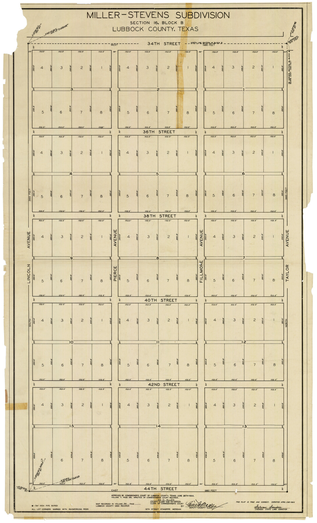
Miller-Stevens Subdivision Section 16, Block B
-
Map/Doc
92401
-
Collection
Twichell Survey Records
-
Object Dates
6/26/1944 (Creation Date)
-
People and Organizations
Sylvan Sanders (Surveyor/Engineer)
-
Counties
Lubbock
-
Height x Width
24.2 x 39.8 inches
61.5 x 101.1 cm
Part of: Twichell Survey Records
[West line of Randall County]
![91705, [West line of Randall County], Twichell Survey Records](https://historictexasmaps.com/wmedia_w700/maps/91705-1.tif.jpg)
Print $20.00
- Digital $50.00
[West line of Randall County]
Size 4.2 x 19.9 inches
Map/Doc 91705

[J. B. Sneed, S. Robinson, and vicinity]
![91041, [J. B. Sneed, S. Robinson, and vicinity], Twichell Survey Records](https://historictexasmaps.com/wmedia_w700/maps/91041-1.tif.jpg)
Print $20.00
- Digital $50.00
[J. B. Sneed, S. Robinson, and vicinity]
Size 32.4 x 12.8 inches
Map/Doc 91041
[Section 2, Block S]
![92860, [Section 2, Block S], Twichell Survey Records](https://historictexasmaps.com/wmedia_w700/maps/92860-1.tif.jpg)
Print $20.00
- Digital $50.00
[Section 2, Block S]
1958
Size 22.2 x 6.8 inches
Map/Doc 92860
Sketch in Floyd County

Print $20.00
- Digital $50.00
Sketch in Floyd County
1911
Size 25.3 x 41.8 inches
Map/Doc 90916
[Surveys in the vicinity of Archibald Smith's Survey and the Cyrena McReara Survey]
![92118, [Surveys in the vicinity of Archibald Smith's Survey and the Cyrena McReara Survey], Twichell Survey Records](https://historictexasmaps.com/wmedia_w700/maps/92118-1.tif.jpg)
Print $20.00
- Digital $50.00
[Surveys in the vicinity of Archibald Smith's Survey and the Cyrena McReara Survey]
Size 27.8 x 32.5 inches
Map/Doc 92118
Lakeview Addition to the City of Shallowater out of the Southeast 1/4 of Section 27, Block D5

Print $3.00
- Digital $50.00
Lakeview Addition to the City of Shallowater out of the Southeast 1/4 of Section 27, Block D5
1955
Size 17.9 x 11.6 inches
Map/Doc 92870
Central Lea County, New Mexico

Print $40.00
- Digital $50.00
Central Lea County, New Mexico
Size 40.6 x 60.2 inches
Map/Doc 89909
[S. M. Walker, D. P. Allen, J. C. Guinn, J. R. Lamar and surrounding surveys]
![90335, [S. M. Walker, D. P. Allen, J. C. Guinn, J. R. Lamar and surrounding surveys], Twichell Survey Records](https://historictexasmaps.com/wmedia_w700/maps/90335-1.tif.jpg)
Print $3.00
- Digital $50.00
[S. M. Walker, D. P. Allen, J. C. Guinn, J. R. Lamar and surrounding surveys]
1912
Size 9.8 x 11.3 inches
Map/Doc 90335
Spade Ranch Hockley County, Texas

Print $20.00
- Digital $50.00
Spade Ranch Hockley County, Texas
1948
Size 14.2 x 19.0 inches
Map/Doc 92225
Amended Map of Wildorado Situated in Oldham County, Texas on Sections 14 & 15 Block Z3

Print $20.00
- Digital $50.00
Amended Map of Wildorado Situated in Oldham County, Texas on Sections 14 & 15 Block Z3
Size 14.9 x 18.4 inches
Map/Doc 92095
[Blocks DT, P, CK, C2, and D7]
![91307, [Blocks DT, P, CK, C2, and D7], Twichell Survey Records](https://historictexasmaps.com/wmedia_w700/maps/91307-1.tif.jpg)
Print $20.00
- Digital $50.00
[Blocks DT, P, CK, C2, and D7]
Size 23.6 x 9.6 inches
Map/Doc 91307
You may also like

Hydograhic Survey H-994, Corpus Christi Pass

Print $40.00
- Digital $50.00
Hydograhic Survey H-994, Corpus Christi Pass
1869
Size 31.8 x 53.7 inches
Map/Doc 2701
Right-of-Way and Track Map, Houston and Brazos Valley Ry. Co. operated by the Houston and Brazos Valley Ry. Co.

Print $40.00
- Digital $50.00
Right-of-Way and Track Map, Houston and Brazos Valley Ry. Co. operated by the Houston and Brazos Valley Ry. Co.
1918
Size 24.9 x 56.5 inches
Map/Doc 64608
McLennan County Sketch File 17

Print $4.00
- Digital $50.00
McLennan County Sketch File 17
1876
Size 7.9 x 12.7 inches
Map/Doc 31278
Foard County Sketch File 2

Print $40.00
- Digital $50.00
Foard County Sketch File 2
Size 23.8 x 16.3 inches
Map/Doc 11490
Map of the Houston & Texas Central Railway and connections

Print $20.00
- Digital $50.00
Map of the Houston & Texas Central Railway and connections
1871
Size 16.6 x 15.4 inches
Map/Doc 95753
Reconnaissance of the Coast of Texas between Matagorda and Corpus Christi Bays

Print $20.00
- Digital $50.00
Reconnaissance of the Coast of Texas between Matagorda and Corpus Christi Bays
1858
Size 25.2 x 21.4 inches
Map/Doc 75987
Karnes County Working Sketch 3

Print $20.00
- Digital $50.00
Karnes County Working Sketch 3
1943
Size 34.6 x 31.4 inches
Map/Doc 66651
Fractional Township No. 8 South Range No. 22 East of the Indian Meridian, Indian Territory

Print $20.00
- Digital $50.00
Fractional Township No. 8 South Range No. 22 East of the Indian Meridian, Indian Territory
1897
Size 19.2 x 24.2 inches
Map/Doc 75239

Sutton County Sketch File 37

Print $20.00
- Digital $50.00
Sutton County Sketch File 37
Size 19.7 x 19.7 inches
Map/Doc 12387