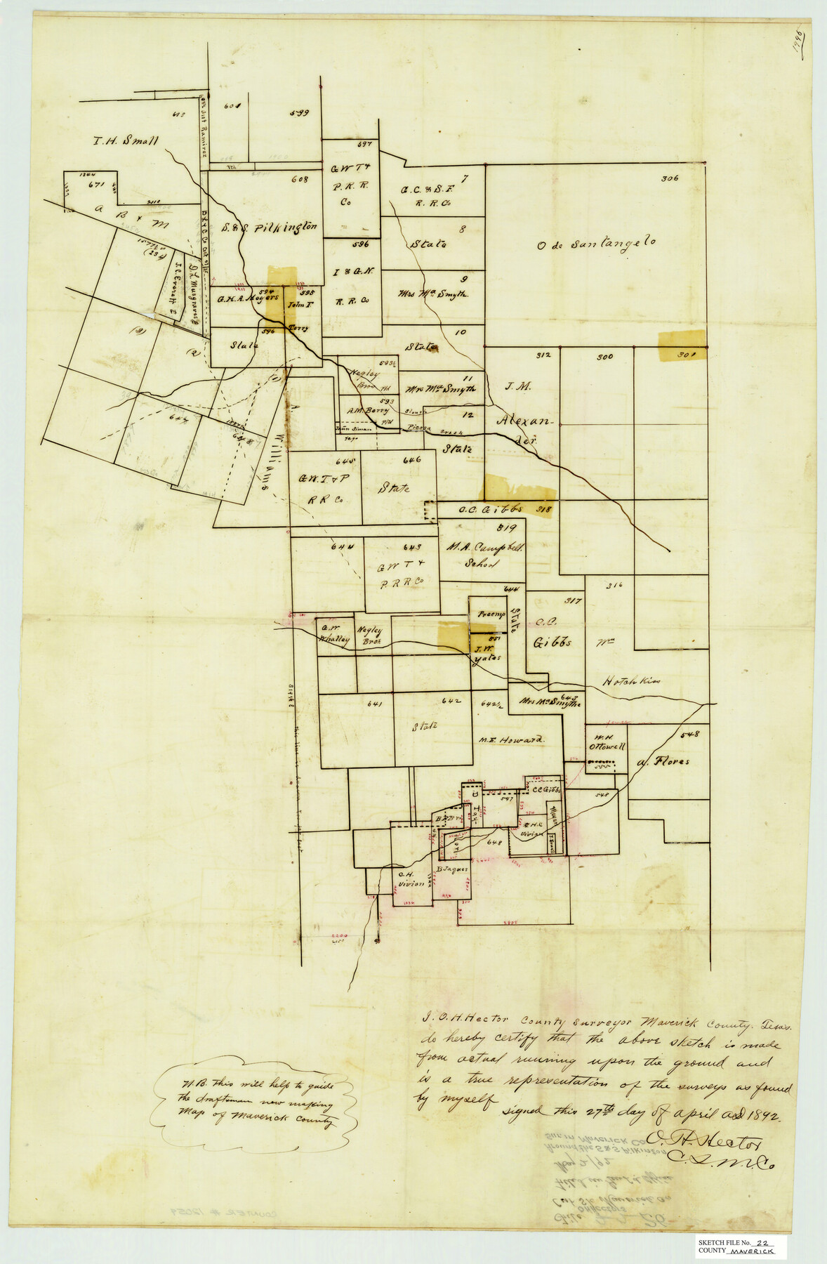
Maverick County Sketch File 22
[Sketch and connecting lines of area around the S. &S. Pilkington survey 608 in the east part of the county and extending into Zavala County]
-
Map/Doc
31136
-
Collection
General Map Collection
-
Object Dates
4/1892 (Creation Date)
5/2/1892 (File Date)
-
People and Organizations
O.H. Hector (Surveyor/Engineer)
-
Counties
Maverick
-
Subjects
Surveying Sketch File
-
Height x Width
5.5 x 6.3 inches
14.0 x 16.0 cm
-
Medium
paper, manuscript
-
Features
Elm Creek
Picosa Creek
Part of: General Map Collection
Scurry County Rolled Sketch 2A

Print $20.00
- Digital $50.00
Scurry County Rolled Sketch 2A
Size 25.6 x 24.2 inches
Map/Doc 7764
Burnet County Working Sketch 27

Print $20.00
- Digital $50.00
Burnet County Working Sketch 27
2025
Size 24.5 x 36.0 inches
Map/Doc 97419
Clay County Sketch File 46

Print $20.00
- Digital $50.00
Clay County Sketch File 46
1890
Size 18.9 x 19.3 inches
Map/Doc 11098
Roberts County Working Sketch 36

Print $20.00
- Digital $50.00
Roberts County Working Sketch 36
1978
Size 26.6 x 22.3 inches
Map/Doc 63562
Flight Mission No. CGI-3N, Frame 107, Cameron County

Print $20.00
- Digital $50.00
Flight Mission No. CGI-3N, Frame 107, Cameron County
1954
Size 18.6 x 22.3 inches
Map/Doc 84587
Montgomery County Working Sketch 6

Print $20.00
- Digital $50.00
Montgomery County Working Sketch 6
1932
Size 24.8 x 32.2 inches
Map/Doc 71112
Flight Mission No. BRA-8M, Frame 27, Jefferson County

Print $20.00
- Digital $50.00
Flight Mission No. BRA-8M, Frame 27, Jefferson County
1953
Size 18.6 x 22.3 inches
Map/Doc 85582
Matagorda County Sketch File 30

Print $20.00
- Digital $50.00
Matagorda County Sketch File 30
1911
Size 22.2 x 31.9 inches
Map/Doc 12045
Marion County Sketch File 1a

Print $3.00
- Digital $50.00
Marion County Sketch File 1a
1867
Size 17.4 x 7.7 inches
Map/Doc 30559
Pecos County Sketch File 48

Print $4.00
- Digital $50.00
Pecos County Sketch File 48
1935
Size 14.3 x 8.8 inches
Map/Doc 33762

Flight Mission No. DAG-21K, Frame 90, Matagorda County

Print $20.00
- Digital $50.00
Flight Mission No. DAG-21K, Frame 90, Matagorda County
1952
Size 18.5 x 22.2 inches
Map/Doc 86419
You may also like
Coast Chart No. 211 - Padre I. and Laguna Madre, Lat. 27° 12' to Lat. 26° 33', Texas

Print $20.00
- Digital $50.00
Coast Chart No. 211 - Padre I. and Laguna Madre, Lat. 27° 12' to Lat. 26° 33', Texas
1890
Size 41.0 x 33.4 inches
Map/Doc 73501
Bandera County Working Sketch 24

Print $20.00
- Digital $50.00
Bandera County Working Sketch 24
1950
Size 31.6 x 33.0 inches
Map/Doc 67620
[Northwest part of the County]
![90841, [Northwest part of the County], Twichell Survey Records](https://historictexasmaps.com/wmedia_w700/maps/90841-2.tif.jpg)
Print $20.00
- Digital $50.00
[Northwest part of the County]
Size 17.9 x 34.9 inches
Map/Doc 90841
Bastrop County Working Sketch 2

Print $20.00
- Digital $50.00
Bastrop County Working Sketch 2
1913
Size 14.0 x 13.6 inches
Map/Doc 67302
Flight Mission No. DIX-6P, Frame 187, Aransas County

Print $20.00
- Digital $50.00
Flight Mission No. DIX-6P, Frame 187, Aransas County
1956
Size 19.1 x 22.7 inches
Map/Doc 83849
Galveston Island

Print $20.00
- Digital $50.00
Galveston Island
1837
Size 24.1 x 37.2 inches
Map/Doc 2009
Map of Texas containing the Latest Grants & Discoveries

Print $20.00
- Digital $50.00
Map of Texas containing the Latest Grants & Discoveries
1836
Size 13.5 x 9.9 inches
Map/Doc 94039
Culberson County Rolled Sketch 31A

Print $20.00
- Digital $50.00
Culberson County Rolled Sketch 31A
Size 43.4 x 35.6 inches
Map/Doc 8748
From Citizens of Southwestern Nacogdoches County for the Creation of a New Judicial County (Unnamed), Undated

Print $20.00
From Citizens of Southwestern Nacogdoches County for the Creation of a New Judicial County (Unnamed), Undated
2020
Size 19.9 x 21.7 inches
Map/Doc 96412
Freestone County Sketch File 16

Print $4.00
- Digital $50.00
Freestone County Sketch File 16
Size 6.4 x 8.7 inches
Map/Doc 23072
Polk County Texas

Print $20.00
- Digital $50.00
Polk County Texas
1897
Size 27.1 x 21.0 inches
Map/Doc 3956
Cottle County Sketch File 15

Print $4.00
- Digital $50.00
Cottle County Sketch File 15
1891
Size 11.2 x 9.0 inches
Map/Doc 19516