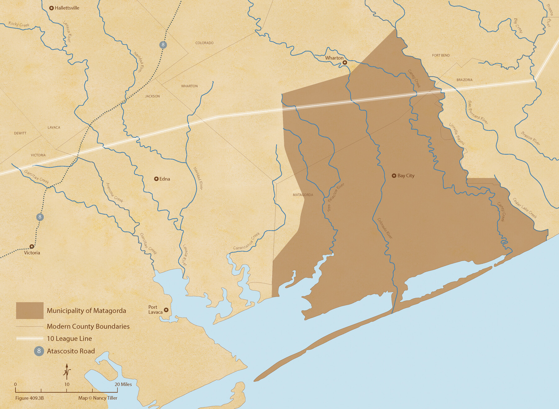
The Mexican Municipality of Matagorda. December 5, 1835
Figure No. 409.3 from 'A Boundary Atlas of Texas, 1821-1845' by Jim Tiller
-
Map/Doc
96027
-
Collection
Nancy and Jim Tiller Digital Collection
-
Object Dates
2020/1/1 (Creation Date)
-
People and Organizations
Jim Tiller (Author)
Nancy Tiller (Cartographer)
Gang Gong (GIS Professional)
-
Subjects
Atlas Mexican Texas Texas Boundaries
-
Height x Width
15.9 x 21.7 inches
40.4 x 55.1 cm
-
Medium
digital image
-
Comments
To purchase a digital PDF copy of "A Boundary Atlas of Texas, 1821-1845" see 96437.
Part of: Nancy and Jim Tiller Digital Collection
From Citizens of Shelby County for the Creation of a New County (Unnamed), July 14, 1838

Print $20.00
From Citizens of Shelby County for the Creation of a New County (Unnamed), July 14, 1838
2020
Size 25.5 x 21.7 inches
Map/Doc 96383
The Chief Justice County of Goliad. Proposed, No Date

Print $20.00
The Chief Justice County of Goliad. Proposed, No Date
2020
Size 14.7 x 21.7 inches
Map/Doc 96046
The Republic County of Jefferson. Spring 1842

Print $20.00
The Republic County of Jefferson. Spring 1842
2020
Size 22.6 x 21.7 inches
Map/Doc 96200
The Judicial District/County of Pashcal. Created, January 28, 1841

Print $20.00
The Judicial District/County of Pashcal. Created, January 28, 1841
2020
Size 15.0 x 21.7 inches
Map/Doc 96343
The Republic County of Travis. Refined, February 5, 1840

Print $20.00
The Republic County of Travis. Refined, February 5, 1840
2020
Size 20.8 x 21.6 inches
Map/Doc 96290
The Mexican Municipality of Matagorda. December 5, 1835

Print $20.00
The Mexican Municipality of Matagorda. December 5, 1835
2020
Size 15.9 x 21.7 inches
Map/Doc 96027
The Republic County of Matagorda. 1841

Print $20.00
The Republic County of Matagorda. 1841
2020
Size 21.0 x 21.7 inches
Map/Doc 96219
From Citizens of Nacogdoches County Living East of the Trinity River and Along the Old San Antonio Road for the Creation of a New County (Unnamed), April 22, 1837

Print $20.00
From Citizens of Nacogdoches County Living East of the Trinity River and Along the Old San Antonio Road for the Creation of a New County (Unnamed), April 22, 1837
2020
Size 19.9 x 21.7 inches
Map/Doc 96374
The Republic County of Sabine. December 29, 1845

Print $20.00
The Republic County of Sabine. December 29, 1845
2020
Size 17.6 x 21.7 inches
Map/Doc 96270
The Republic County of Austin. February 1, 1844

Print $20.00
The Republic County of Austin. February 1, 1844
2020
Size 14.7 x 21.7 inches
Map/Doc 96087
The Republic County of Montgomery. February 2, 1842

Print $20.00
The Republic County of Montgomery. February 2, 1842
2020
Size 19.9 x 21.7 inches
Map/Doc 96239
The Republic County of Brazoria. January 1, 1838

Print $20.00
The Republic County of Brazoria. January 1, 1838
2020
Size 14.7 x 21.8 inches
Map/Doc 96111
You may also like
Calhoun County Working Sketch 13

Print $20.00
- Digital $50.00
Calhoun County Working Sketch 13
1962
Size 28.5 x 31.9 inches
Map/Doc 67829
General Highway Map, Winkler County, Texas

Print $20.00
General Highway Map, Winkler County, Texas
1961
Size 18.2 x 24.8 inches
Map/Doc 79716
Flight Mission No. BRA-6M, Frame 74, Jefferson County

Print $20.00
- Digital $50.00
Flight Mission No. BRA-6M, Frame 74, Jefferson County
1953
Size 18.6 x 22.3 inches
Map/Doc 85418
Flight Mission No. BQR-12K, Frame 47, Brazoria County

Print $20.00
- Digital $50.00
Flight Mission No. BQR-12K, Frame 47, Brazoria County
1952
Size 18.7 x 22.4 inches
Map/Doc 84062
Kinney County Rolled Sketch 17

Print $20.00
- Digital $50.00
Kinney County Rolled Sketch 17
1965
Size 18.4 x 21.5 inches
Map/Doc 6544
Hansford County Sketch File 13

Print $12.00
- Digital $50.00
Hansford County Sketch File 13
1989
Size 11.2 x 8.8 inches
Map/Doc 24978
Sutton County Working Sketch 44

Print $20.00
- Digital $50.00
Sutton County Working Sketch 44
1951
Size 29.8 x 27.5 inches
Map/Doc 62387
Map of Shackelford County, Texas

Print $20.00
- Digital $50.00
Map of Shackelford County, Texas
1879
Size 28.7 x 23.4 inches
Map/Doc 616
Flight Mission No. CGI-3N, Frame 99, Cameron County

Print $20.00
- Digital $50.00
Flight Mission No. CGI-3N, Frame 99, Cameron County
1954
Size 18.5 x 22.1 inches
Map/Doc 84579
Briscoe County Sketch File D

Print $40.00
- Digital $50.00
Briscoe County Sketch File D
1918
Size 25.8 x 22.9 inches
Map/Doc 11001
San Patricio County Rolled Sketch 29B

Print $20.00
- Digital $50.00
San Patricio County Rolled Sketch 29B
1936
Size 25.8 x 31.0 inches
Map/Doc 7582
Haskell County

Print $20.00
- Digital $50.00
Haskell County
1873
Size 21.0 x 25.2 inches
Map/Doc 3643