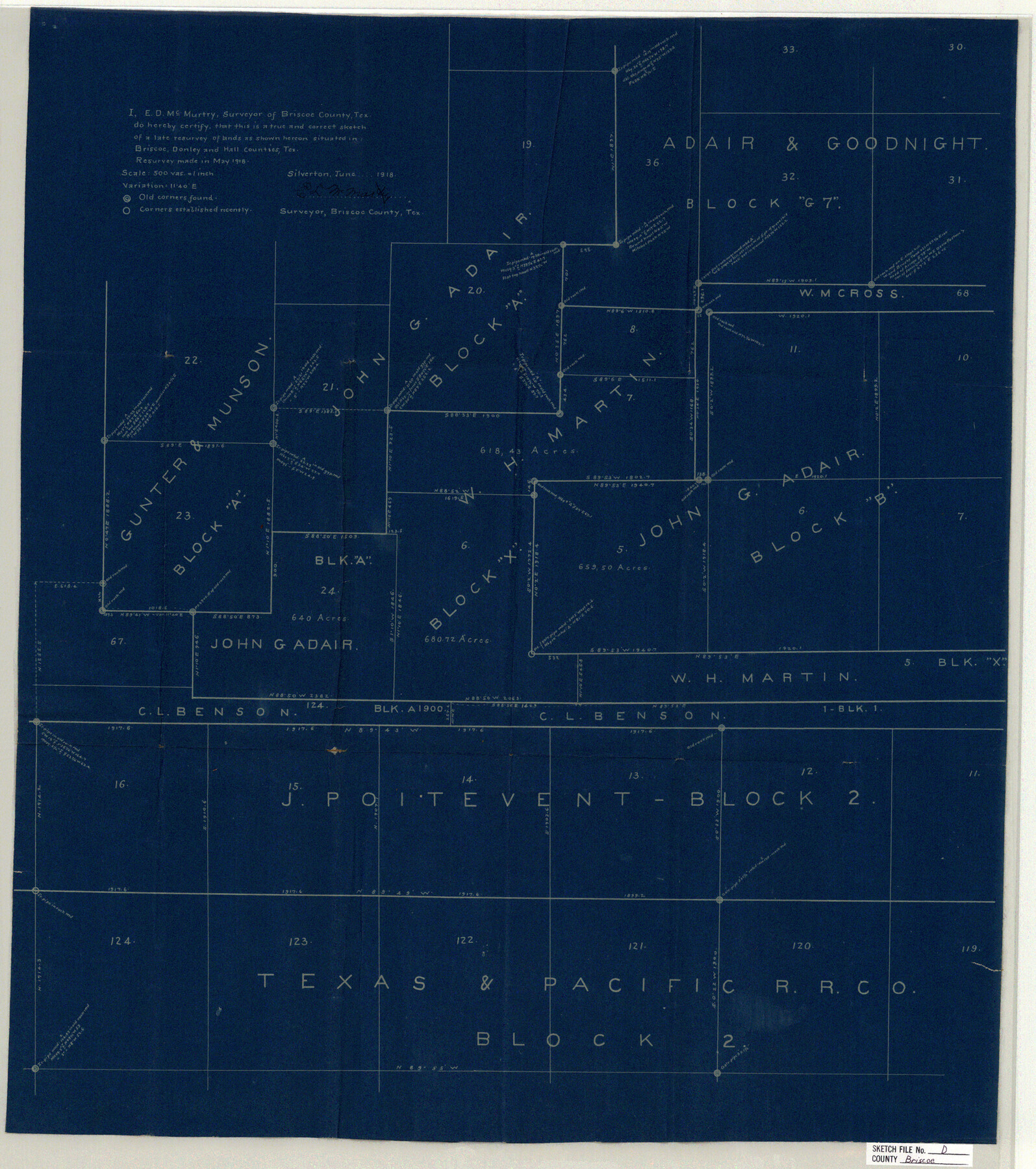
Briscoe County Sketch File D
[Sketch of area in extreme northeast corner of Briscoe County]
-
Map/Doc
11001
-
Collection
General Map Collection
-
Object Dates
1918 (Creation Date)
1918/10/18 (File Date)
1918 (Survey Date)
-
People and Organizations
E.D. McMurtry (Surveyor/Engineer)
-
Counties
Donley Hall Briscoe
-
Subjects
Surveying Sketch File
-
Height x Width
25.8 x 22.9 inches
65.5 x 58.2 cm
-
Medium
blueprint/diazo
-
Scale
1" = 500 varas
Part of: General Map Collection
Irion County Sketch File 4

Print $12.00
- Digital $50.00
Irion County Sketch File 4
1900
Size 13.7 x 8.8 inches
Map/Doc 27457
Northwest Part Pecos County

Print $20.00
- Digital $50.00
Northwest Part Pecos County
1975
Size 43.4 x 44.2 inches
Map/Doc 95612
Terrell County Working Sketch 14

Print $20.00
- Digital $50.00
Terrell County Working Sketch 14
1926
Size 39.4 x 44.9 inches
Map/Doc 62163
Plan of the City of Galveston, Texas

Print $20.00
- Digital $50.00
Plan of the City of Galveston, Texas
1845
Size 18.2 x 27.4 inches
Map/Doc 62969
Jeff Davis County Rolled Sketch 6

Print $20.00
- Digital $50.00
Jeff Davis County Rolled Sketch 6
1889
Size 41.3 x 26.4 inches
Map/Doc 6360
Newton County Rolled Sketch 25

Print $20.00
- Digital $50.00
Newton County Rolled Sketch 25
1893
Size 22.3 x 18.6 inches
Map/Doc 6852
Amistad International Reservoir on Rio Grande 62

Print $20.00
- Digital $50.00
Amistad International Reservoir on Rio Grande 62
1949
Size 28.2 x 39.6 inches
Map/Doc 73347
Lynn County Boundary File 8

Print $4.00
- Digital $50.00
Lynn County Boundary File 8
Size 10.4 x 8.6 inches
Map/Doc 56655
Flight Mission No. DCL-6C, Frame 131, Kenedy County

Print $20.00
- Digital $50.00
Flight Mission No. DCL-6C, Frame 131, Kenedy County
1943
Size 18.7 x 22.3 inches
Map/Doc 85961
Duval County Working Sketch 46

Print $20.00
- Digital $50.00
Duval County Working Sketch 46
1980
Size 29.4 x 27.2 inches
Map/Doc 68770
Tom Green County Sketch File 63A

Print $20.00
- Digital $50.00
Tom Green County Sketch File 63A
1891
Size 24.9 x 34.5 inches
Map/Doc 12446
San Jacinto County Rolled Sketch 14

Print $20.00
- Digital $50.00
San Jacinto County Rolled Sketch 14
1998
Size 25.8 x 37.2 inches
Map/Doc 7569
You may also like
Rusk County Working Sketch 30

Print $20.00
- Digital $50.00
Rusk County Working Sketch 30
1931
Size 22.9 x 21.4 inches
Map/Doc 63667
Ward County Sketch File 9

Print $25.00
- Digital $50.00
Ward County Sketch File 9
1937
Size 10.8 x 8.9 inches
Map/Doc 39623
Flight Mission No. DAG-18K, Frame 181, Matagorda County

Print $20.00
- Digital $50.00
Flight Mission No. DAG-18K, Frame 181, Matagorda County
1952
Size 15.9 x 15.9 inches
Map/Doc 86373
Chambers County NRC Article 33.136 Sketch 5

Print $22.00
- Digital $50.00
Chambers County NRC Article 33.136 Sketch 5
2003
Size 24.2 x 18.3 inches
Map/Doc 78608
Kerr County Rolled Sketch 4

Print $20.00
- Digital $50.00
Kerr County Rolled Sketch 4
Size 21.8 x 23.1 inches
Map/Doc 6493
Tyler County Rolled Sketch 9

Print $20.00
- Digital $50.00
Tyler County Rolled Sketch 9
Size 43.3 x 25.6 inches
Map/Doc 8059
America siue India Nova ad magnae Gerardi Mercatoris aui Vniversalis imitationem in compendium redacta

Print $20.00
- Digital $50.00
America siue India Nova ad magnae Gerardi Mercatoris aui Vniversalis imitationem in compendium redacta
1585
Size 16.9 x 20.2 inches
Map/Doc 93808
Childress County

Print $20.00
- Digital $50.00
Childress County
1892
Size 24.7 x 19.6 inches
Map/Doc 3391
El Paso County Working Sketch 5

Print $20.00
- Digital $50.00
El Paso County Working Sketch 5
1916
Size 21.5 x 37.2 inches
Map/Doc 69027
Starr County Sketch File 41

Print $20.00
- Digital $50.00
Starr County Sketch File 41
1941
Size 26.6 x 31.1 inches
Map/Doc 12340
Wichita County Working Sketch 19

Print $20.00
- Digital $50.00
Wichita County Working Sketch 19
1949
Size 18.1 x 30.9 inches
Map/Doc 72529
McMullen County Sketch File 42

Print $6.00
- Digital $50.00
McMullen County Sketch File 42
1941
Size 14.2 x 8.9 inches
Map/Doc 31418