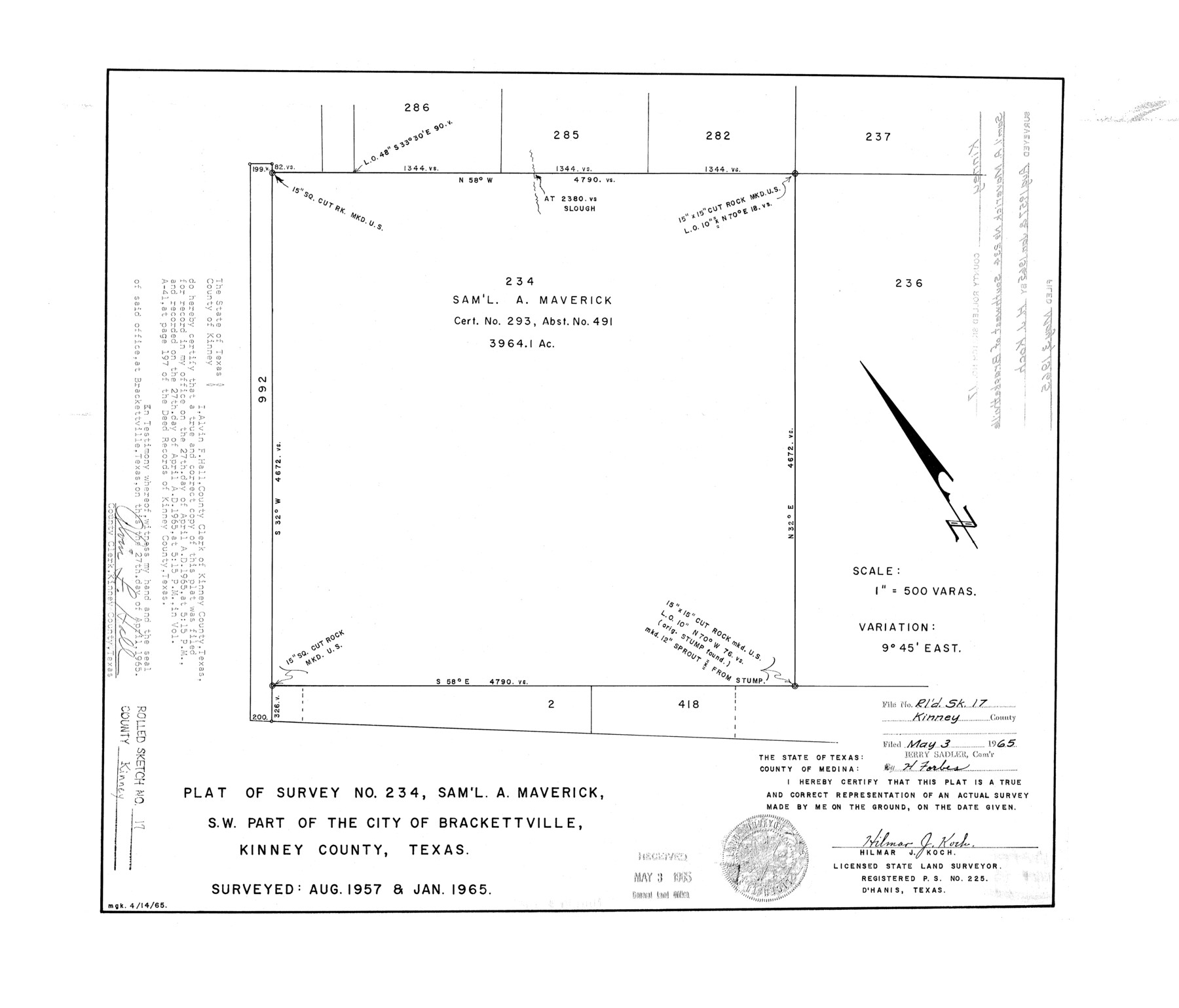
Kinney County Rolled Sketch 17
Plat of survey no. 234, Sam'l A. Maverick, SW part of the City of Brackettville, Kinney County, Texas
-
Map/Doc
6544
-
Collection
General Map Collection
-
Object Dates
1965 (Survey Date)
1965/5/3 (File Date)
1965/4/14 (Creation Date)
-
People and Organizations
Hilmar J. Koch (Surveyor/Engineer)
-
Counties
Kinney
-
Subjects
Surveying Rolled Sketch
-
Height x Width
18.4 x 21.5 inches
46.7 x 54.6 cm
-
Scale
1" = 500 varas
Part of: General Map Collection
Andrews County Sketch File 10

Print $40.00
- Digital $50.00
Andrews County Sketch File 10
1950
Size 27.4 x 18.2 inches
Map/Doc 10810
Martin County Sketch File 3

Print $19.00
- Digital $50.00
Martin County Sketch File 3
Size 7.4 x 8.6 inches
Map/Doc 30632
Flight Mission No. BRA-8M, Frame 88, Jefferson County

Print $20.00
- Digital $50.00
Flight Mission No. BRA-8M, Frame 88, Jefferson County
1953
Size 18.6 x 22.3 inches
Map/Doc 85608

Flight Mission No. DAH-9M, Frame 202, Orange County

Print $20.00
- Digital $50.00
Flight Mission No. DAH-9M, Frame 202, Orange County
1953
Size 18.5 x 22.6 inches
Map/Doc 86870
Harris County Rolled Sketch 80

Print $20.00
- Digital $50.00
Harris County Rolled Sketch 80
1958
Size 31.1 x 31.0 inches
Map/Doc 6116
Runnels County Working Sketch 21

Print $20.00
- Digital $50.00
Runnels County Working Sketch 21
1951
Size 43.6 x 37.0 inches
Map/Doc 63617
Kinney County Working Sketch 29

Print $20.00
- Digital $50.00
Kinney County Working Sketch 29
1959
Size 37.8 x 33.8 inches
Map/Doc 70211
Winkler County Working Sketch 17

Print $20.00
- Digital $50.00
Winkler County Working Sketch 17
1973
Size 36.5 x 36.7 inches
Map/Doc 72611

Burnet County Sketch File 1

Print $40.00
- Digital $50.00
Burnet County Sketch File 1
1847
Size 16.1 x 12.4 inches
Map/Doc 16670
Zavala County Working Sketch 29

Print $20.00
- Digital $50.00
Zavala County Working Sketch 29
1994
Size 33.1 x 42.9 inches
Map/Doc 62104
You may also like
Liberty County Working Sketch 71

Print $20.00
- Digital $50.00
Liberty County Working Sketch 71
1977
Size 37.3 x 31.8 inches
Map/Doc 70531
The Texarkana Gateway to Texas and the Southwest issued jointly by the Iron Mountain Route, the Cotton Belt Route, the Texas & Pacific Railway, and the International & Great Northern Railroad

The Texarkana Gateway to Texas and the Southwest issued jointly by the Iron Mountain Route, the Cotton Belt Route, the Texas & Pacific Railway, and the International & Great Northern Railroad
1896
Size 6.6 x 9.4 inches
Map/Doc 96585
Robertson County Sketch File 5

Print $6.00
Robertson County Sketch File 5
1863
Size 12.0 x 9.0 inches
Map/Doc 35358
City of Corpus Christi, Texas

Print $20.00
- Digital $50.00
City of Corpus Christi, Texas
1969
Size 22.6 x 51.0 inches
Map/Doc 96520
Map of Survey made for Bascom Giles, General Land Commissioner, covering Bob Reid Mineral Application No. 35521

Print $20.00
- Digital $50.00
Map of Survey made for Bascom Giles, General Land Commissioner, covering Bob Reid Mineral Application No. 35521
1941
Size 26.5 x 19.1 inches
Map/Doc 91964
Maps of Gulf Intracoastal Waterway, Texas - Sabine River to the Rio Grande and connecting waterways including ship channels

Print $20.00
- Digital $50.00
Maps of Gulf Intracoastal Waterway, Texas - Sabine River to the Rio Grande and connecting waterways including ship channels
1966
Size 15.6 x 22.0 inches
Map/Doc 61984
Webb County Sketch File 56

Print $20.00
- Digital $50.00
Webb County Sketch File 56
1940
Size 18.4 x 20.7 inches
Map/Doc 12651
Sketch C Showing the Progress of the Survey in Section III From 1843 to 1852

Print $20.00
- Digital $50.00
Sketch C Showing the Progress of the Survey in Section III From 1843 to 1852
1852
Size 36.2 x 25.6 inches
Map/Doc 97201
Ochiltree County Boundary File 1b

Print $16.00
- Digital $50.00
Ochiltree County Boundary File 1b
Size 8.6 x 8.4 inches
Map/Doc 57666
Clay County Sketch File 15

Print $4.00
- Digital $50.00
Clay County Sketch File 15
1873
Size 12.8 x 8.4 inches
Map/Doc 18419
Adrian Heights Adition (sic) to Adrian Located in Section 16, Block K11

Print $2.00
- Digital $50.00
Adrian Heights Adition (sic) to Adrian Located in Section 16, Block K11
Size 15.6 x 7.6 inches
Map/Doc 92097
La Salle County

Print $40.00
- Digital $50.00
La Salle County
1923
Size 48.5 x 43.5 inches
Map/Doc 95562