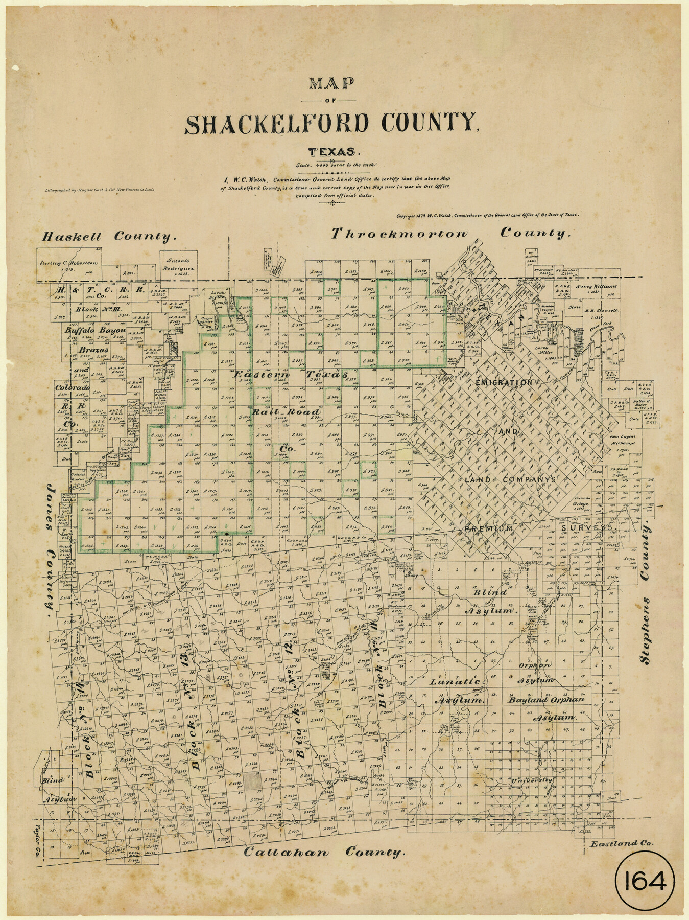
Map of Shackelford County, Texas
-
Map/Doc
616
-
Collection
Maddox Collection
-
Object Dates
1879 (Creation Date)
-
People and Organizations
General Land Office (Publisher)
W.C. Walsh (GLO Commissioner)
August Gast & Co. (Lithographer)
-
Counties
Shackelford
-
Subjects
County
-
Height x Width
28.7 x 23.4 inches
72.9 x 59.4 cm
-
Medium
paper, etching/engraving/lithograph
-
Scale
1" = 4000 varas
-
Comments
Conservation funded in 2011 by Friends of the Texas General Land Office.
-
Features
Fort Griffen Road
Willow Creek
Cottage Creek
Asylum Creek
Deep Creek
Jenny's Creek
South Fork of Mill Creek
Deadmans Creek
Phantom Hill Road
Clear Fork of Brazos River
Fort Griffin and Phantom Hill Road
Albany
South Fork [of Fall Creek]
Fall Creek
West Fork of Hubbards Creek
Mill Creek
Foyle's Creek
Part of: Maddox Collection
[Surveying sketch of Dan'l. Dunham, O. de Santangelo, et al in Zavala County]
![708, [Surveying sketch of Dan'l. Dunham, O. de Santangelo, et al in Zavala County], Maddox Collection](https://historictexasmaps.com/wmedia_w700/maps/0708.tif.jpg)
Print $20.00
- Digital $50.00
[Surveying sketch of Dan'l. Dunham, O. de Santangelo, et al in Zavala County]
Size 16.2 x 16.0 inches
Map/Doc 708
Denton County, Texas

Print $20.00
- Digital $50.00
Denton County, Texas
1870
Size 18.6 x 22.7 inches
Map/Doc 723
Childress County, Texas

Print $20.00
- Digital $50.00
Childress County, Texas
1890
Size 19.9 x 16.9 inches
Map/Doc 673
Map showing lands of D. Sullivan known as Santa Rosa Ranch situated in Cameron and Hidalgo Counties, Texas

Print $20.00
- Digital $50.00
Map showing lands of D. Sullivan known as Santa Rosa Ranch situated in Cameron and Hidalgo Counties, Texas
1905
Size 26.2 x 23.2 inches
Map/Doc 4455
Sketch showing connections made in survey of the Jerry Barton preemption

Print $20.00
- Digital $50.00
Sketch showing connections made in survey of the Jerry Barton preemption
1892
Size 18.7 x 23.6 inches
Map/Doc 75557
[Plat Showing San Gabriel & 24th Street Intersection, Outlot 4, Travis County, Texas]
![75795, [Plat Showing San Gabriel & 24th Street Intersection, Outlot 4, Travis County, Texas], Maddox Collection](https://historictexasmaps.com/wmedia_w700/maps/75795.tif.jpg)
Print $2.00
- Digital $50.00
[Plat Showing San Gabriel & 24th Street Intersection, Outlot 4, Travis County, Texas]
Size 11.4 x 8.7 inches
Map/Doc 75795
Map of Colorado County, Texas

Print $20.00
- Digital $50.00
Map of Colorado County, Texas
Size 28.6 x 23.5 inches
Map/Doc 700
Sketch compiled from records of Collin County in General Land Office

Print $3.00
- Digital $50.00
Sketch compiled from records of Collin County in General Land Office
1878
Size 11.5 x 13.5 inches
Map/Doc 504
Bell County, Texas

Print $20.00
- Digital $50.00
Bell County, Texas
1879
Size 23.7 x 29.0 inches
Map/Doc 516
Working Sketch in Dimmit Co.

Print $20.00
- Digital $50.00
Working Sketch in Dimmit Co.
1883
Size 14.9 x 14.6 inches
Map/Doc 436
[Sketch showing County School Land Surveys in Throckmorton Counties, Texas]
![628, [Sketch showing County School Land Surveys in Throckmorton Counties, Texas], Maddox Collection](https://historictexasmaps.com/wmedia_w700/maps/628-GC.tif.jpg)
Print $20.00
- Digital $50.00
[Sketch showing County School Land Surveys in Throckmorton Counties, Texas]
1889
Size 15.9 x 20.2 inches
Map/Doc 628
Nolan County, Texas

Print $20.00
- Digital $50.00
Nolan County, Texas
1870
Size 23.9 x 19.5 inches
Map/Doc 744
You may also like
Nueces County Rolled Sketch 26

Print $40.00
- Digital $50.00
Nueces County Rolled Sketch 26
1945
Size 24.3 x 122.6 inches
Map/Doc 9595
Flight Mission No. CZW-2R, Frame 66, Hardeman County

Print $20.00
- Digital $50.00
Flight Mission No. CZW-2R, Frame 66, Hardeman County
1956
Size 18.6 x 22.4 inches
Map/Doc 85239
Map of the St. Louis, Iron Mountain and Southern Railway, and connections

Print $20.00
- Digital $50.00
Map of the St. Louis, Iron Mountain and Southern Railway, and connections
1877
Size 13.0 x 18.9 inches
Map/Doc 95783
Flight Mission No. DIX-5P, Frame 115, Aransas County

Print $20.00
- Digital $50.00
Flight Mission No. DIX-5P, Frame 115, Aransas County
1956
Size 17.5 x 17.6 inches
Map/Doc 83794
Clay County Sketch File 36

Print $3.00
- Digital $50.00
Clay County Sketch File 36
Size 17.0 x 11.0 inches
Map/Doc 18464
English Field Notes of the Spanish Archives - Book D

English Field Notes of the Spanish Archives - Book D
1835
Map/Doc 96542
Report of the Superintendent of the Coast Survey showing the progress of the survey during the year 1852

Report of the Superintendent of the Coast Survey showing the progress of the survey during the year 1852
1853
Map/Doc 81738
Map of Dawson County

Print $20.00
- Digital $50.00
Map of Dawson County
1900
Size 40.0 x 36.5 inches
Map/Doc 4929
Presidio County Working Sketch 55

Print $20.00
- Digital $50.00
Presidio County Working Sketch 55
1955
Size 22.0 x 16.9 inches
Map/Doc 71732
Oldham County Working Sketch 9

Print $20.00
- Digital $50.00
Oldham County Working Sketch 9
1982
Size 33.3 x 37.2 inches
Map/Doc 71331
Arlancy the Land of Plenty Farms

Print $20.00
- Digital $50.00
Arlancy the Land of Plenty Farms
1925
Size 10.9 x 16.6 inches
Map/Doc 96737
Survey plat of lots 2, 4, 6, 8, 10-16, Block 322 of the original town site of Jourdanton known as School File 154507

Print $4.00
- Digital $50.00
Survey plat of lots 2, 4, 6, 8, 10-16, Block 322 of the original town site of Jourdanton known as School File 154507
2001
Size 26.0 x 27.7 inches
Map/Doc 60392