Terrell County Boundary File 1
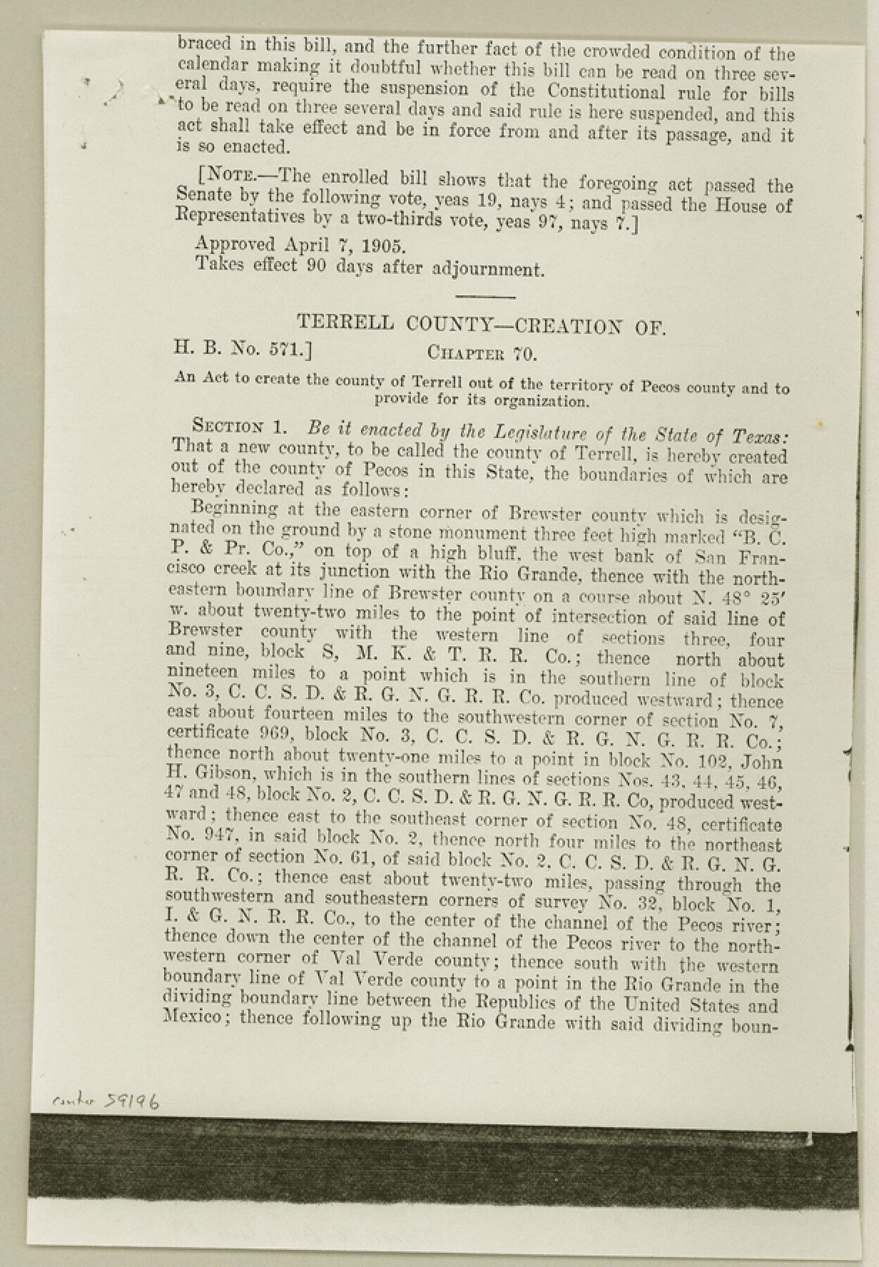
Terrell County - Creation of, Chapter 70, H. B. No. 571
-
Map/Doc
59196
-
Collection
General Map Collection
-
Counties
Terrell
-
Subjects
County Boundaries
-
Height x Width
8.9 x 6.2 inches
22.6 x 15.7 cm
Part of: General Map Collection
Duval County Sketch File 40b

Print $20.00
- Digital $50.00
Duval County Sketch File 40b
Size 28.0 x 31.4 inches
Map/Doc 11396
El Paso County Working Sketch 21

Print $20.00
- Digital $50.00
El Paso County Working Sketch 21
1960
Size 37.8 x 30.9 inches
Map/Doc 69043
New Map of Texas prepared and published for the Bureau of Immigration of the State of Texas

Print $20.00
- Digital $50.00
New Map of Texas prepared and published for the Bureau of Immigration of the State of Texas
1875
Size 15.8 x 18.3 inches
Map/Doc 93625
Baylor County Rolled Sketch 11

Print $20.00
- Digital $50.00
Baylor County Rolled Sketch 11
Size 19.4 x 19.9 inches
Map/Doc 5128
McMullen County Sketch File 22

Print $4.00
- Digital $50.00
McMullen County Sketch File 22
Size 10.0 x 8.1 inches
Map/Doc 31377
Travis County Sketch File 69

Print $6.00
- Digital $50.00
Travis County Sketch File 69
1955
Size 14.3 x 8.9 inches
Map/Doc 38451
Calhoun County Aerial Photograph Index Sheet 2

Print $20.00
- Digital $50.00
Calhoun County Aerial Photograph Index Sheet 2
1953
Size 24.1 x 19.8 inches
Map/Doc 83671
San Jacinto County Rolled Sketch 14

Print $20.00
- Digital $50.00
San Jacinto County Rolled Sketch 14
1998
Size 25.8 x 37.2 inches
Map/Doc 7569
Flight Mission No. DCL-7C, Frame 46, Kenedy County

Print $20.00
- Digital $50.00
Flight Mission No. DCL-7C, Frame 46, Kenedy County
1943
Size 15.4 x 15.3 inches
Map/Doc 86034
Amistad International Reservoir on Rio Grande 85

Print $20.00
- Digital $50.00
Amistad International Reservoir on Rio Grande 85
1949
Size 28.4 x 40.2 inches
Map/Doc 75514
Nolan County Sketch File 20

Print $40.00
- Digital $50.00
Nolan County Sketch File 20
1954
Size 21.1 x 22.4 inches
Map/Doc 42168
Coast Chart No. 212 - From Latitude 26° 33' to the Rio Grande Texas

Print $20.00
- Digital $50.00
Coast Chart No. 212 - From Latitude 26° 33' to the Rio Grande Texas
1886
Size 18.4 x 27.8 inches
Map/Doc 72826
You may also like
Navigation Maps of Gulf Intracoastal Waterway, Port Arthur to Brownsville, Texas

Print $4.00
- Digital $50.00
Navigation Maps of Gulf Intracoastal Waterway, Port Arthur to Brownsville, Texas
1951
Size 16.7 x 21.5 inches
Map/Doc 65439
Garza County Working Sketch 1

Print $20.00
- Digital $50.00
Garza County Working Sketch 1
1902
Size 39.3 x 25.6 inches
Map/Doc 63148
Crockett County

Print $40.00
- Digital $50.00
Crockett County
1882
Size 57.2 x 38.3 inches
Map/Doc 88864
Terrell County Sketch File 16

Print $24.00
- Digital $50.00
Terrell County Sketch File 16
1902
Size 12.1 x 8.8 inches
Map/Doc 37924
Swisher County Rolled Sketch 3

Print $20.00
- Digital $50.00
Swisher County Rolled Sketch 3
Size 21.3 x 19.4 inches
Map/Doc 7904
Florida called by ye French Louisiana & c.

Print $20.00
- Digital $50.00
Florida called by ye French Louisiana & c.
1728
Size 9.6 x 14.3 inches
Map/Doc 94110
Flight Mission No. DIX-5P, Frame 113, Aransas County

Print $20.00
- Digital $50.00
Flight Mission No. DIX-5P, Frame 113, Aransas County
1956
Size 17.6 x 17.7 inches
Map/Doc 83792
Shelby County Rolled Sketch 14

Print $20.00
- Digital $50.00
Shelby County Rolled Sketch 14
1948
Size 33.1 x 25.9 inches
Map/Doc 7782
Orange County Sketch File A

Print $40.00
- Digital $50.00
Orange County Sketch File A
1890
Size 14.2 x 8.8 inches
Map/Doc 33278

Flight Mission No. DAG-19K, Frame 61, Matagorda County

Print $20.00
- Digital $50.00
Flight Mission No. DAG-19K, Frame 61, Matagorda County
1952
Size 18.6 x 22.3 inches
Map/Doc 86388
Revised Sectional Map No. 4 showing land surveys in the western portion of the county of El Paso, Texas

Print $20.00
- Digital $50.00
Revised Sectional Map No. 4 showing land surveys in the western portion of the county of El Paso, Texas
Size 19.0 x 24.2 inches
Map/Doc 4477