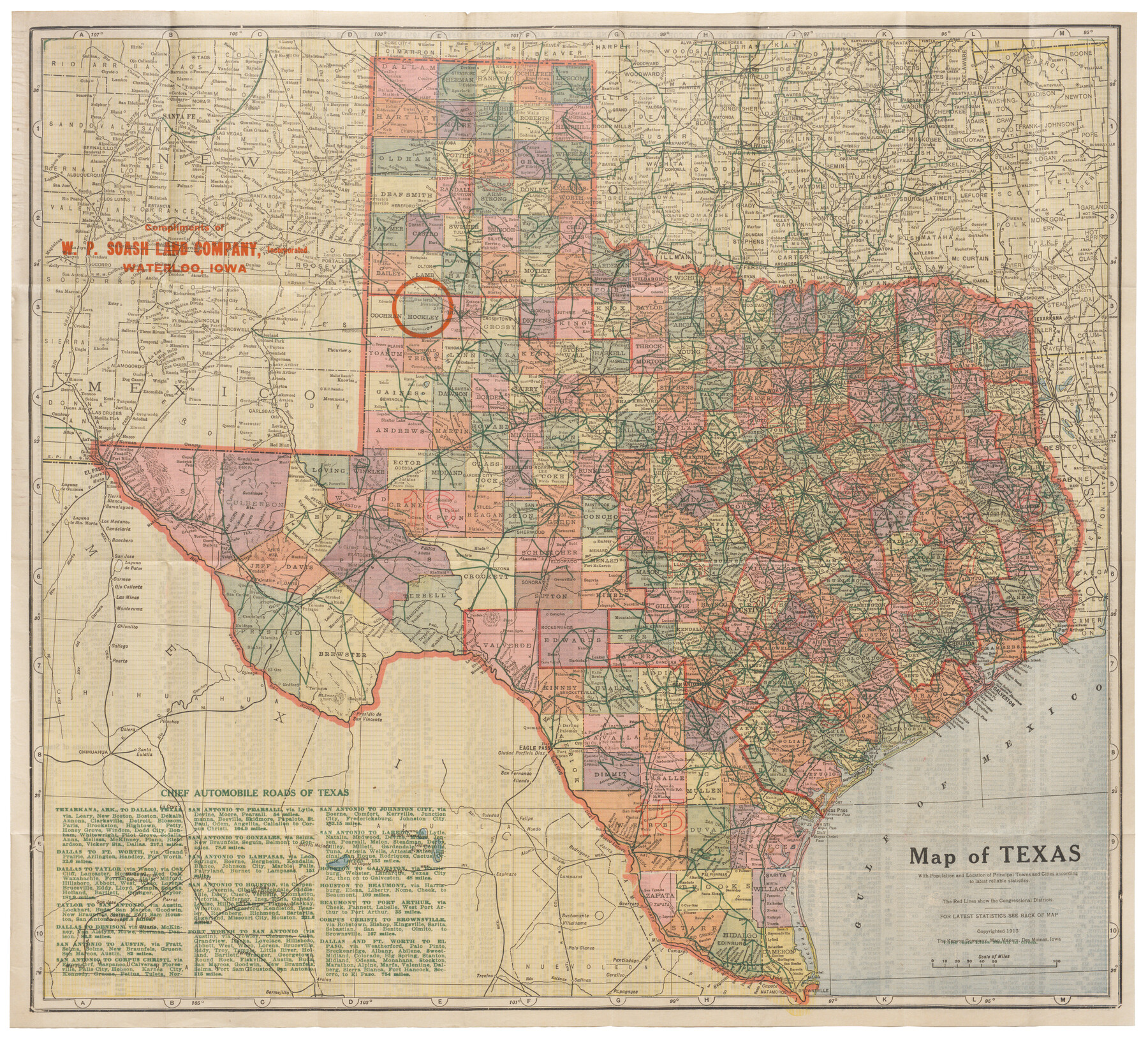
Map of Texas with population and location of principal towns and cities according to latest reliable statistics
-
Map/Doc
95879
-
Collection
Cobb Digital Map Collection
-
Object Dates
1913 (Creation Date)
-
People and Organizations
The Kenyon Company (Publisher)
The Kenyon Company (Printer)
-
Subjects
Railroads State of Texas
-
Height x Width
18.3 x 20.2 inches
46.5 x 51.3 cm
-
Medium
digital image
-
Comments
Map branded by W.P. Soash Land Company.
Courtesy of John & Diana Cobb.
To view statistics printed on verso and original cover in which this map was folded, click "Download PDF" link above.
Part of: Cobb Digital Map Collection
Map of the St. Louis, Iron Mountain and Southern Railway, and connections

Print $20.00
- Digital $50.00
Map of the St. Louis, Iron Mountain and Southern Railway, and connections
1880
Size 10.5 x 14.4 inches
Map/Doc 95786

The Industrial Evolution of the agricultural wonderland of the southwest

Print $20.00
- Digital $50.00
The Industrial Evolution of the agricultural wonderland of the southwest
1927
Size 13.7 x 16.7 inches
Map/Doc 96760
[The Frisco Line - St. Louis & San Francisco Railway through the Great West and South West]
![95794, [The Frisco Line - St. Louis & San Francisco Railway through the Great West and South West], Cobb Digital Map Collection - 1](https://historictexasmaps.com/wmedia_w700/maps/95794.tif.jpg)
Print $20.00
- Digital $50.00
[The Frisco Line - St. Louis & San Francisco Railway through the Great West and South West]
1893
Size 16.8 x 40.2 inches
Map/Doc 95794
Houston - Where Seventeen Railroads Meet the Sea

Houston - Where Seventeen Railroads Meet the Sea
1913
Size 6.1 x 8.2 inches
Map/Doc 97069
Rand, McNally & Co.'s Texas

Print $20.00
- Digital $50.00
Rand, McNally & Co.'s Texas
1887
Size 27.2 x 30.7 inches
Map/Doc 95884

State of Texas showing the Lower Rio Grande Valley

Print $20.00
- Digital $50.00
State of Texas showing the Lower Rio Grande Valley
1920
Size 14.0 x 13.4 inches
Map/Doc 95802
Map of the Texas & Pacific Railway and connections

Print $20.00
- Digital $50.00
Map of the Texas & Pacific Railway and connections
1898
Size 17.8 x 36.4 inches
Map/Doc 95764

A New and Correct County Map of the State of Texas

Print $20.00
- Digital $50.00
A New and Correct County Map of the State of Texas
1891
Size 22.4 x 27.3 inches
Map/Doc 95760
[Map of North Carolina and South Carolina]
![96621, [Map of North Carolina and South Carolina], Cobb Digital Map Collection](https://historictexasmaps.com/wmedia_w700/maps/96621.tif.jpg)
Print $20.00
- Digital $50.00
[Map of North Carolina and South Carolina]
1869
Size 8.9 x 9.2 inches
Map/Doc 96621
You may also like
Newton County Working Sketch 16

Print $20.00
- Digital $50.00
Newton County Working Sketch 16
1950
Size 15.8 x 15.5 inches
Map/Doc 71262
Flight Mission No. DQN-2K, Frame 33, Calhoun County

Print $20.00
- Digital $50.00
Flight Mission No. DQN-2K, Frame 33, Calhoun County
1953
Size 18.6 x 22.2 inches
Map/Doc 84240
Map of Texas with population and location of principal towns and cities according to latest reliable statistics

Print $20.00
- Digital $50.00
Map of Texas with population and location of principal towns and cities according to latest reliable statistics
1910
Size 19.1 x 20.6 inches
Map/Doc 95878
[I. Killough and Hiram Cates surveys and vicinity]
![91851, [I. Killough and Hiram Cates surveys and vicinity], Twichell Survey Records](https://historictexasmaps.com/wmedia_w700/maps/91851-1.tif.jpg)
Print $20.00
- Digital $50.00
[I. Killough and Hiram Cates surveys and vicinity]
Size 27.5 x 9.2 inches
Map/Doc 91851
Tarrant County State Real Property Sketch 4

Print $20.00
- Digital $50.00
Tarrant County State Real Property Sketch 4
2018
Size 47.8 x 35.9 inches
Map/Doc 95403
Correct Map Lamb County (skeleton sketch)

Print $40.00
- Digital $50.00
Correct Map Lamb County (skeleton sketch)
Size 56.2 x 79.4 inches
Map/Doc 93139
Travis County Sketch File 61

Print $8.00
- Digital $50.00
Travis County Sketch File 61
1948
Size 14.4 x 8.8 inches
Map/Doc 38427
Fisher County Sketch File 18

Print $12.00
- Digital $50.00
Fisher County Sketch File 18
1901
Size 8.2 x 5.5 inches
Map/Doc 22589
Wichita County Sketch File 17

Print $20.00
- Digital $50.00
Wichita County Sketch File 17
1889
Size 29.7 x 22.4 inches
Map/Doc 12680
Ector County Working Sketch 3

Print $20.00
- Digital $50.00
Ector County Working Sketch 3
1940
Size 26.4 x 31.2 inches
Map/Doc 68846

DeWitt County Rolled Sketch 2

Print $20.00
- Digital $50.00
DeWitt County Rolled Sketch 2
1943
Size 32.0 x 42.7 inches
Map/Doc 8778