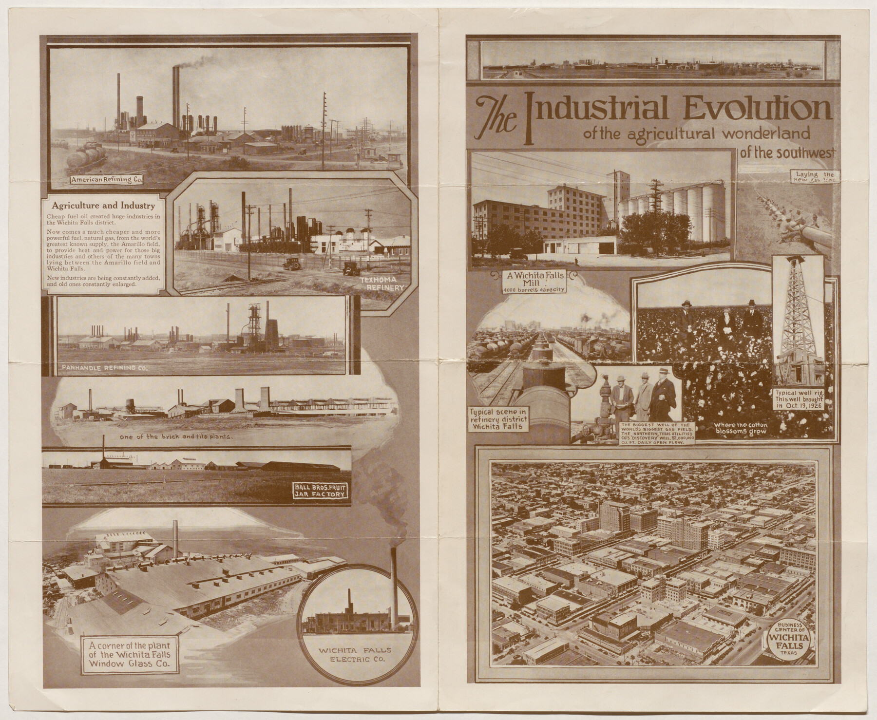
The Industrial Evolution of the agricultural wonderland of the southwest
-
Map/Doc
96760
-
Collection
Cobb Digital Map Collection
-
Object Dates
[1927] (Creation Date)
-
Height x Width
13.7 x 16.7 inches
34.8 x 42.4 cm
-
Medium
digital image
-
Comments
Courtesy of John & Diana Cobb.
For promotional scenes of Wichita Falls on verso see 96761.
Related maps
Typical Scenes of Wichita Falls and District

Print $20.00
- Digital $50.00
Typical Scenes of Wichita Falls and District
1927
Size 13.7 x 16.6 inches
Map/Doc 96761
Part of: Cobb Digital Map Collection


Catalogue of Maps, Charts, Atlases, Globes, etc.

Catalogue of Maps, Charts, Atlases, Globes, etc.
1891
Size 9.2 x 6.5 inches
Map/Doc 95841
Map of Rock Island Lines and Connections - Route of Golden State Limited to California / Rocky Mountain Limited to Colorado

Print $20.00
- Digital $50.00
Map of Rock Island Lines and Connections - Route of Golden State Limited to California / Rocky Mountain Limited to Colorado
1923
Size 18.3 x 32.6 inches
Map/Doc 95890
Capitol Land and Investment Company's List of Texas Lands

Capitol Land and Investment Company's List of Texas Lands
1907
Size 7.9 x 5.2 inches
Map/Doc 97052

Sectional map of Texas traversed by the Missouri, Kansas & Texas Railway, showing the crops adapted to each section, with the elevation and annual rainfall

Print $20.00
- Digital $50.00
Sectional map of Texas traversed by the Missouri, Kansas & Texas Railway, showing the crops adapted to each section, with the elevation and annual rainfall
1904
Size 21.9 x 23.0 inches
Map/Doc 95815

Santa Fe Lines - Texas, Oklahoma, and Louisiana

Print $20.00
- Digital $50.00
Santa Fe Lines - Texas, Oklahoma, and Louisiana
1923
Size 9.3 x 8.3 inches
Map/Doc 96595
Houston, Texas - Where 17 Railroads meet the Sea

Houston, Texas - Where 17 Railroads meet the Sea
1922
Size 8.5 x 10.4 inches
Map/Doc 97070
[Map of Santa Fe Route - Atchison, Topeka, and Santa Fe Railroad]
![95866, [Map of Santa Fe Route - Atchison, Topeka, and Santa Fe Railroad], Cobb Digital Map Collection - 1](https://historictexasmaps.com/wmedia_w700/maps/95866.tif.jpg)
Print $40.00
- Digital $50.00
[Map of Santa Fe Route - Atchison, Topeka, and Santa Fe Railroad]
1893
Size 17.4 x 50.0 inches
Map/Doc 95866
Texas with population and location of principal towns and cities according to latest reliable statistics

Print $20.00
- Digital $50.00
Texas with population and location of principal towns and cities according to latest reliable statistics
1912
Size 19.0 x 21.2 inches
Map/Doc 95877
You may also like
Map of the Missouri Pacific and St. Louis, Iron Mountain and Southern Railways and Connections

Print $20.00
- Digital $50.00
Map of the Missouri Pacific and St. Louis, Iron Mountain and Southern Railways and Connections
1898
Size 17.7 x 32.1 inches
Map/Doc 95791
Working Sketch Bastrop County

Print $20.00
- Digital $50.00
Working Sketch Bastrop County
1923
Size 22.7 x 13.2 inches
Map/Doc 90149
Lamar County Sketch File 2

Print $4.00
- Digital $50.00
Lamar County Sketch File 2
1859
Size 12.1 x 7.5 inches
Map/Doc 29273
Midland County Rolled Sketch 14

Print $40.00
- Digital $50.00
Midland County Rolled Sketch 14
Size 56.6 x 43.5 inches
Map/Doc 73574
Lamar County Working Sketch 11

Print $20.00
- Digital $50.00
Lamar County Working Sketch 11
1980
Size 19.8 x 16.9 inches
Map/Doc 70272
Brazoria County Sketch File 40

Print $8.00
- Digital $50.00
Brazoria County Sketch File 40
1935
Size 14.3 x 8.9 inches
Map/Doc 15049
Kinney County Working Sketch 4

Print $20.00
- Digital $50.00
Kinney County Working Sketch 4
1907
Size 21.1 x 21.6 inches
Map/Doc 70186
Flight Mission No. CRC-4R, Frame 76, Chambers County

Print $20.00
- Digital $50.00
Flight Mission No. CRC-4R, Frame 76, Chambers County
1956
Size 18.8 x 22.4 inches
Map/Doc 84880
Map of Kent County, 1889

Print $20.00
- Digital $50.00
Map of Kent County, 1889
1889
Size 27.2 x 20.2 inches
Map/Doc 3756
McLennan County

Print $20.00
- Digital $50.00
McLennan County
1946
Size 42.5 x 45.8 inches
Map/Doc 73235
Webb County Rolled Sketch 2

Print $20.00
- Digital $50.00
Webb County Rolled Sketch 2
1881
Size 19.4 x 27.6 inches
Map/Doc 8169
Part of the boundary between the United States and Texas; north of Sabine River, from the 72nd mile mound to the Red River

Print $3.00
- Digital $50.00
Part of the boundary between the United States and Texas; north of Sabine River, from the 72nd mile mound to the Red River
1842
Size 12.8 x 8.1 inches
Map/Doc 93771