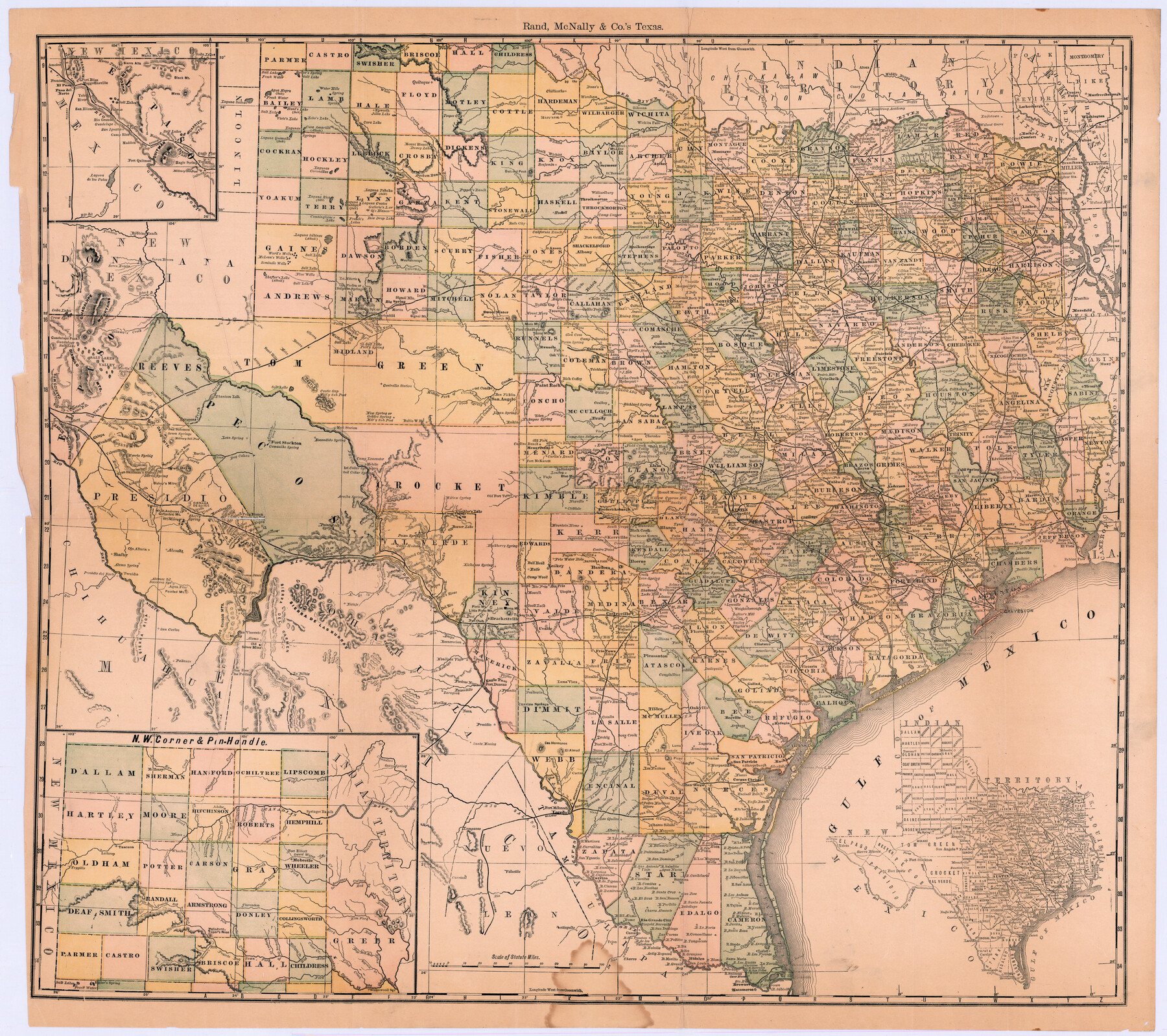
Rand, McNally & Co.'s Texas
[Inset 1: El Paso] / [Inset 2:] NW Corner & Pan-Handle
-
Map/Doc
95884
-
Collection
Cobb Digital Map Collection
-
Object Dates
1887 (Creation Date)
-
Subjects
Railroads State of Texas
-
Height x Width
27.2 x 30.7 inches
69.1 x 78.0 cm
-
Medium
digital image
-
Comments
Courtesy of John & Diana Cobb.
Part of: Cobb Digital Map Collection
Texas, an Agricultural Empire

Texas, an Agricultural Empire
1915
Size 10.8 x 8.0 inches
Map/Doc 96593

[Map of Texas showing Frisco Lines]
![95796, [Map of Texas showing Frisco Lines], Cobb Digital Map Collection](https://historictexasmaps.com/wmedia_w700/maps/95796.tif.jpg)
Print $20.00
- Digital $50.00
[Map of Texas showing Frisco Lines]
1910
Size 19.8 x 19.2 inches
Map/Doc 95796
Correct Map of Texas

Print $20.00
- Digital $50.00
Correct Map of Texas
1873
Size 21.5 x 16.9 inches
Map/Doc 95775

San Antonio - Places of Interest and how to get there

San Antonio - Places of Interest and how to get there
1920
Map/Doc 96785
Three Through Trains for Texas Travelers via Katy Line - Missouri, Kansas and Texas Railway from Chicago, St. Louis, Kansas City and a comprehensive local service reaching all points in Missouri, Kansas, Texas and Indian Territory

Three Through Trains for Texas Travelers via Katy Line - Missouri, Kansas and Texas Railway from Chicago, St. Louis, Kansas City and a comprehensive local service reaching all points in Missouri, Kansas, Texas and Indian Territory
Size 9.5 x 6.3 inches
Map/Doc 96605
Texas with population and location of principal towns and cities according to latest reliable statistics

Print $20.00
- Digital $50.00
Texas with population and location of principal towns and cities according to latest reliable statistics
1912
Size 19.0 x 21.2 inches
Map/Doc 95877
Scenes Around Carrizo Springs, Texas the Hub of the Winter Garden District

Print $20.00
- Digital $50.00
Scenes Around Carrizo Springs, Texas the Hub of the Winter Garden District
1920
Size 8.8 x 15.5 inches
Map/Doc 96767

Port Houston, the Commercial Center of the South and West

Port Houston, the Commercial Center of the South and West
1900
Size 4.9 x 6.5 inches
Map/Doc 97068
The "Magic Valley" of the Lower Rio Grande - the Land of Golden Fruit

The "Magic Valley" of the Lower Rio Grande - the Land of Golden Fruit
1930
Map/Doc 96745
You may also like
Baylor County Rolled Sketch WAJ

Print $20.00
- Digital $50.00
Baylor County Rolled Sketch WAJ
Size 22.0 x 17.0 inches
Map/Doc 5132
Erath County Sketch File 16

Print $4.00
- Digital $50.00
Erath County Sketch File 16
1872
Size 12.9 x 8.3 inches
Map/Doc 22294
Bandera County Working Sketch 40

Print $20.00
- Digital $50.00
Bandera County Working Sketch 40
1977
Size 29.9 x 23.7 inches
Map/Doc 67636
Coleman County Sketch File 43a

Print $6.00
- Digital $50.00
Coleman County Sketch File 43a
1892
Size 13.2 x 8.2 inches
Map/Doc 18780
Brewster County Rolled Sketch 66

Print $20.00
- Digital $50.00
Brewster County Rolled Sketch 66
1940
Size 33.0 x 36.2 inches
Map/Doc 8490
[Map of Clay County]
![3402, [Map of Clay County], General Map Collection](https://historictexasmaps.com/wmedia_w700/maps/3402-1.tif.jpg)
Print $20.00
- Digital $50.00
[Map of Clay County]
1860
Size 28.3 x 19.1 inches
Map/Doc 3402
Survey Map of Runnels County

Print $20.00
- Digital $50.00
Survey Map of Runnels County
Size 33.6 x 40.3 inches
Map/Doc 92918
Atascosa County Rolled Sketch 10

Print $40.00
- Digital $50.00
Atascosa County Rolled Sketch 10
1943
Size 36.0 x 77.6 inches
Map/Doc 8428
Yoakum County

Print $20.00
- Digital $50.00
Yoakum County
1932
Size 47.1 x 35.6 inches
Map/Doc 63139
Edwards County Boundary File 1

Print $18.00
- Digital $50.00
Edwards County Boundary File 1
Size 15.5 x 5.5 inches
Map/Doc 52853
King County Working Sketch 16

Print $40.00
- Digital $50.00
King County Working Sketch 16
1979
Size 41.4 x 59.4 inches
Map/Doc 70180
Menard County Boundary File 9

Print $4.00
- Digital $50.00
Menard County Boundary File 9
Size 9.9 x 8.1 inches
Map/Doc 57094