Tarrant County State Real Property Sketch 4
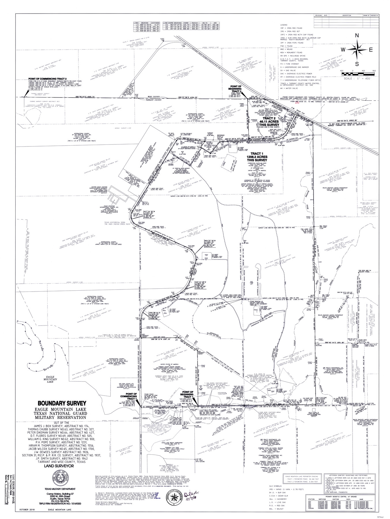
Boundary Survey, Eagle Mountain Lake Texas National Guard Military Reservation
-
Map/Doc
95403
-
Collection
General Map Collection
-
Object Dates
2018/12/7 (Creation Date)
2019/4/26 (File Date)
-
People and Organizations
David A. Rolbiecki (Surveyor/Engineer)
-
Counties
Tarrant Wise
-
Subjects
State Real Property
-
Height x Width
47.8 x 35.9 inches
121.4 x 91.2 cm
-
Medium
mylar, print
-
Scale
1" = 400'
-
Comments
See surveyor's report in Tarrant County Sketch File 36 (95395).
Related maps
Tarrant County Sketch File 36

Print $56.00
- Digital $50.00
Tarrant County Sketch File 36
2018
Size 11.0 x 8.5 inches
Map/Doc 95395
Part of: General Map Collection
Montgomery County Sketch File 40

Print $8.00
- Digital $50.00
Montgomery County Sketch File 40
1914
Size 11.3 x 8.8 inches
Map/Doc 31925

Jack County Working Sketch 21

Print $20.00
- Digital $50.00
Jack County Working Sketch 21
1993
Size 28.3 x 40.0 inches
Map/Doc 66447
Aransas County Rolled Sketch 24

Print $20.00
- Digital $50.00
Aransas County Rolled Sketch 24
Size 22.5 x 34.8 inches
Map/Doc 77495
Tarrant County Sketch File 36
Print $56.00
- Digital $50.00
Tarrant County Sketch File 36
2018
Size 11.0 x 8.5 inches
Map/Doc 95395
Map of Red River County

Print $20.00
- Digital $50.00
Map of Red River County
1872
Size 21.6 x 17.7 inches
Map/Doc 3979
[G. C. & S. F. Ry. Northern-Division, Alignment and Right of Way Map, Weatherford Branch, Johnson and Hood Counties, Texas]
![64648, [G. C. & S. F. Ry. Northern-Division, Alignment and Right of Way Map, Weatherford Branch, Johnson and Hood Counties, Texas], General Map Collection](https://historictexasmaps.com/wmedia_w700/maps/64648.tif.jpg)
Print $40.00
- Digital $50.00
[G. C. & S. F. Ry. Northern-Division, Alignment and Right of Way Map, Weatherford Branch, Johnson and Hood Counties, Texas]
1935
Size 37.4 x 120.9 inches
Map/Doc 64648
Maps & Lists Showing Prison Lands (Oil & Gas) Leased as of June 1955

Digital $50.00
Maps & Lists Showing Prison Lands (Oil & Gas) Leased as of June 1955
Size 11.2 x 8.7 inches
Map/Doc 62871
Refugio County Sketch File 21

Print $20.00
- Digital $50.00
Refugio County Sketch File 21
1933
Size 17.8 x 22.1 inches
Map/Doc 12248
El Paso County Sketch File 30

Print $4.00
- Digital $50.00
El Paso County Sketch File 30
1960
Size 11.2 x 8.8 inches
Map/Doc 22082
Lamb County Rolled Sketch 10

Print $40.00
- Digital $50.00
Lamb County Rolled Sketch 10
1912
Size 31.7 x 70.6 inches
Map/Doc 9418
Starr County Working Sketch 11

Print $20.00
- Digital $50.00
Starr County Working Sketch 11
1944
Size 18.1 x 17.7 inches
Map/Doc 63927
You may also like
[Sketch showing Blocks 5, M-20, 22 and strip of Block BB]
![91723, [Sketch showing Blocks 5, M-20, 22 and strip of Block BB], Twichell Survey Records](https://historictexasmaps.com/wmedia_w700/maps/91723-1.tif.jpg)
Print $2.00
- Digital $50.00
[Sketch showing Blocks 5, M-20, 22 and strip of Block BB]
Size 7.1 x 10.4 inches
Map/Doc 91723
Crockett County Sketch File 67

Print $20.00
- Digital $50.00
Crockett County Sketch File 67
1927
Size 30.1 x 26.6 inches
Map/Doc 11231
Frio County Sketch File 15

Print $6.00
- Digital $50.00
Frio County Sketch File 15
1949
Size 11.3 x 8.8 inches
Map/Doc 23145
[Capitol Leagues Eastward from Bl, LC2 to H. & T.C. Blk. 44]
![89921, [Capitol Leagues Eastward from Bl, LC2 to H. & T.C. Blk. 44], Twichell Survey Records](https://historictexasmaps.com/wmedia_w700/maps/89921-1.tif.jpg)
Print $40.00
- Digital $50.00
[Capitol Leagues Eastward from Bl, LC2 to H. & T.C. Blk. 44]
Size 64.0 x 41.9 inches
Map/Doc 89921
Sketch Showing Portion of League 4, Wilson County School Land in Lynn County

Print $20.00
- Digital $50.00
Sketch Showing Portion of League 4, Wilson County School Land in Lynn County
Size 20.9 x 22.6 inches
Map/Doc 92941
[Map of Jackson County]
![78359, [Map of Jackson County], General Map Collection](https://historictexasmaps.com/wmedia_w700/maps/78359.tif.jpg)
Print $20.00
- Digital $50.00
[Map of Jackson County]
1836
Size 32.8 x 21.1 inches
Map/Doc 78359

Cottle County Sketch File 13

Print $20.00
- Digital $50.00
Cottle County Sketch File 13
1904
Size 15.8 x 15.8 inches
Map/Doc 11195
Limestone County Sketch File 24

Print $8.00
- Digital $50.00
Limestone County Sketch File 24
1942
Size 11.2 x 8.8 inches
Map/Doc 30206
Marion County Working Sketch 24

Print $4.00
- Digital $50.00
Marion County Working Sketch 24
1960
Size 21.4 x 26.4 inches
Map/Doc 70800
Randall County Sketch File 11

Print $4.00
- Digital $50.00
Randall County Sketch File 11
1944
Size 3.4 x 5.7 inches
Map/Doc 34974
Presidio County Sketch File 85

Print $6.00
- Digital $50.00
Presidio County Sketch File 85
1950
Size 14.3 x 8.9 inches
Map/Doc 34745