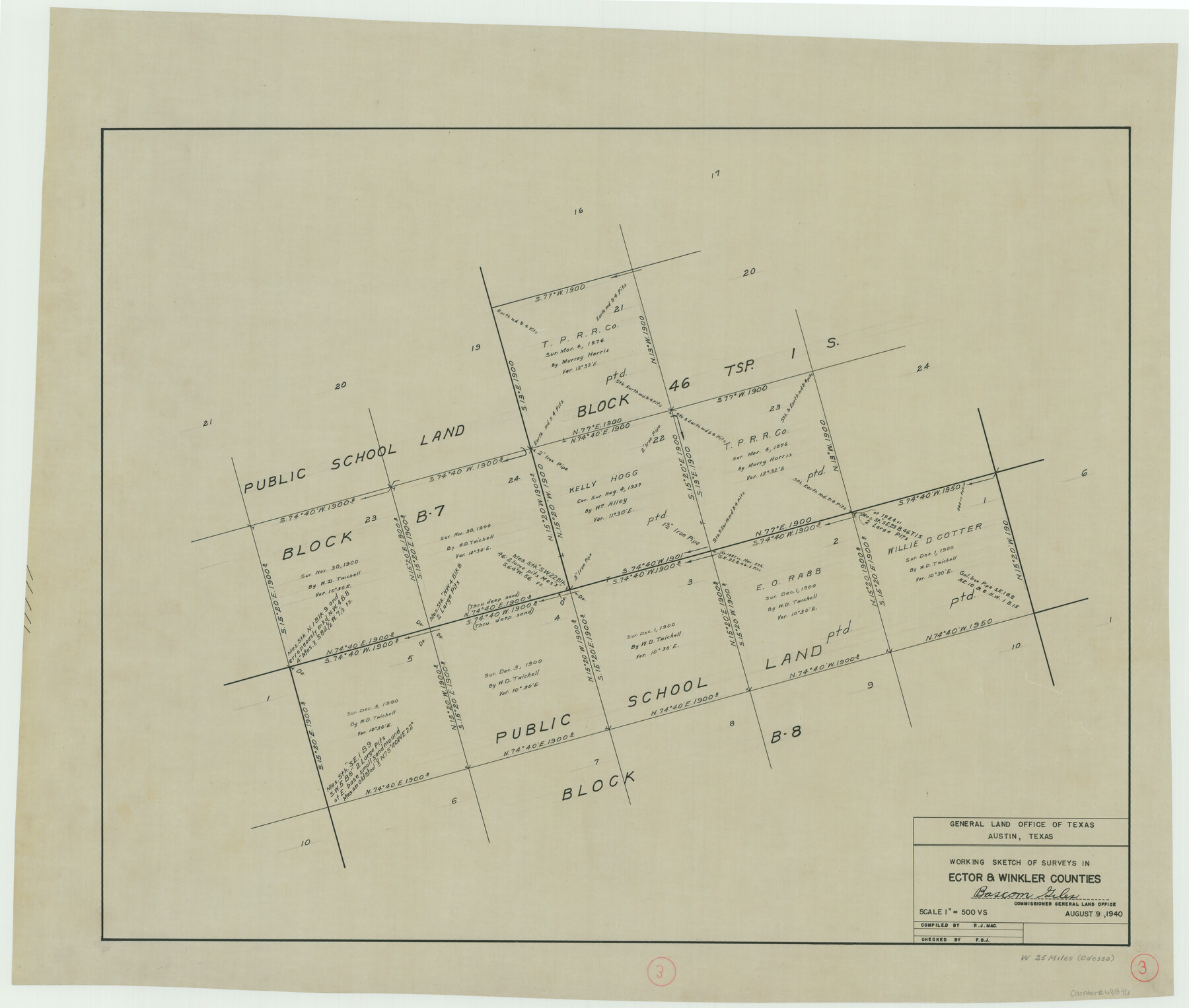
Ector County Working Sketch 3
-
Map/Doc
68846
-
Collection
General Map Collection
-
Object Dates
8/9/1940 (Creation Date)
-
Counties
Ector Winkler
-
Subjects
Surveying Working Sketch
-
Height x Width
26.4 x 31.2 inches
67.1 x 79.3 cm
-
Scale
1" = 500 varas
Part of: General Map Collection
Flight Mission No. CRE-2R, Frame 81, Jackson County

Print $20.00
- Digital $50.00
Flight Mission No. CRE-2R, Frame 81, Jackson County
1956
Size 18.6 x 22.2 inches
Map/Doc 85353
Shelby County Rolled Sketch 18

Print $20.00
- Digital $50.00
Shelby County Rolled Sketch 18
1975
Size 36.2 x 40.7 inches
Map/Doc 9926
Le Nouveau Mexique appelé aussi Nouvelle Grenade et Marata, avec partie de Californie

Print $20.00
- Digital $50.00
Le Nouveau Mexique appelé aussi Nouvelle Grenade et Marata, avec partie de Californie
Size 21.5 x 25.5 inches
Map/Doc 96630
Railroad Track Map, T&PRRCo., Culberson County, Texas

Print $4.00
- Digital $50.00
Railroad Track Map, T&PRRCo., Culberson County, Texas
1910
Size 11.7 x 18.6 inches
Map/Doc 62829

Hemphill County Boundary File 1

Print $18.00
- Digital $50.00
Hemphill County Boundary File 1
Size 9.0 x 3.9 inches
Map/Doc 54612
Floyd County Sketch File 32

Print $8.00
- Digital $50.00
Floyd County Sketch File 32
1952
Size 14.3 x 8.9 inches
Map/Doc 22792
Pecos County Working Sketch 40

Print $20.00
- Digital $50.00
Pecos County Working Sketch 40
1941
Size 29.9 x 39.7 inches
Map/Doc 71512

Crockett County Rolled Sketch 73

Print $20.00
- Digital $50.00
Crockett County Rolled Sketch 73
1949
Size 10.4 x 23.6 inches
Map/Doc 5614
Red River County Working Sketch 64

Print $20.00
- Digital $50.00
Red River County Working Sketch 64
1973
Size 26.1 x 32.3 inches
Map/Doc 72047
Hopkins County Sketch File 6

Print $7.00
- Digital $50.00
Hopkins County Sketch File 6
1853
Size 12.4 x 8.1 inches
Map/Doc 26689
You may also like
Sutton County Working Sketch 39

Print $20.00
- Digital $50.00
Sutton County Working Sketch 39
1945
Size 29.6 x 25.8 inches
Map/Doc 62382
Flight Mission No. CGI-1N, Frame 178, Cameron County

Print $20.00
- Digital $50.00
Flight Mission No. CGI-1N, Frame 178, Cameron County
1955
Size 18.6 x 22.3 inches
Map/Doc 84513
San Patricio County Rolled Sketch 29A

Print $20.00
- Digital $50.00
San Patricio County Rolled Sketch 29A
1934
Size 37.7 x 45.7 inches
Map/Doc 9895
Jefferson County Working Sketch 42

Print $20.00
- Digital $50.00
Jefferson County Working Sketch 42
1996
Size 31.7 x 47.2 inches
Map/Doc 66586
Shelby County Sketch File 20

Print $20.00
- Digital $50.00
Shelby County Sketch File 20
1879
Size 18.3 x 34.6 inches
Map/Doc 12319
Galveston County NRC Article 33.136 Sketch 50

Print $24.00
- Digital $50.00
Galveston County NRC Article 33.136 Sketch 50
2008
Size 24.0 x 36.3 inches
Map/Doc 88750
Starr County Working Sketch 11

Print $20.00
- Digital $50.00
Starr County Working Sketch 11
1944
Size 18.1 x 17.7 inches
Map/Doc 63927
Ride the Texas Mountain Trail [Recto]
![94164, Ride the Texas Mountain Trail [Recto], General Map Collection](https://historictexasmaps.com/wmedia_w700/maps/94164.tif.jpg)
Ride the Texas Mountain Trail [Recto]
1968
Size 18.4 x 24.3 inches
Map/Doc 94164
Culberson County Working Sketch 21

Print $40.00
- Digital $50.00
Culberson County Working Sketch 21
1936
Size 36.7 x 57.8 inches
Map/Doc 68473
Bell County Working Sketch 15

Print $20.00
- Digital $50.00
Bell County Working Sketch 15
1979
Size 15.7 x 16.2 inches
Map/Doc 67355
[Northeast Portion of Hartley County]
![91118, [Northeast Portion of Hartley County], Twichell Survey Records](https://historictexasmaps.com/wmedia_w700/maps/91118-1.tif.jpg)
Print $2.00
- Digital $50.00
[Northeast Portion of Hartley County]
Size 13.9 x 8.5 inches
Map/Doc 91118
