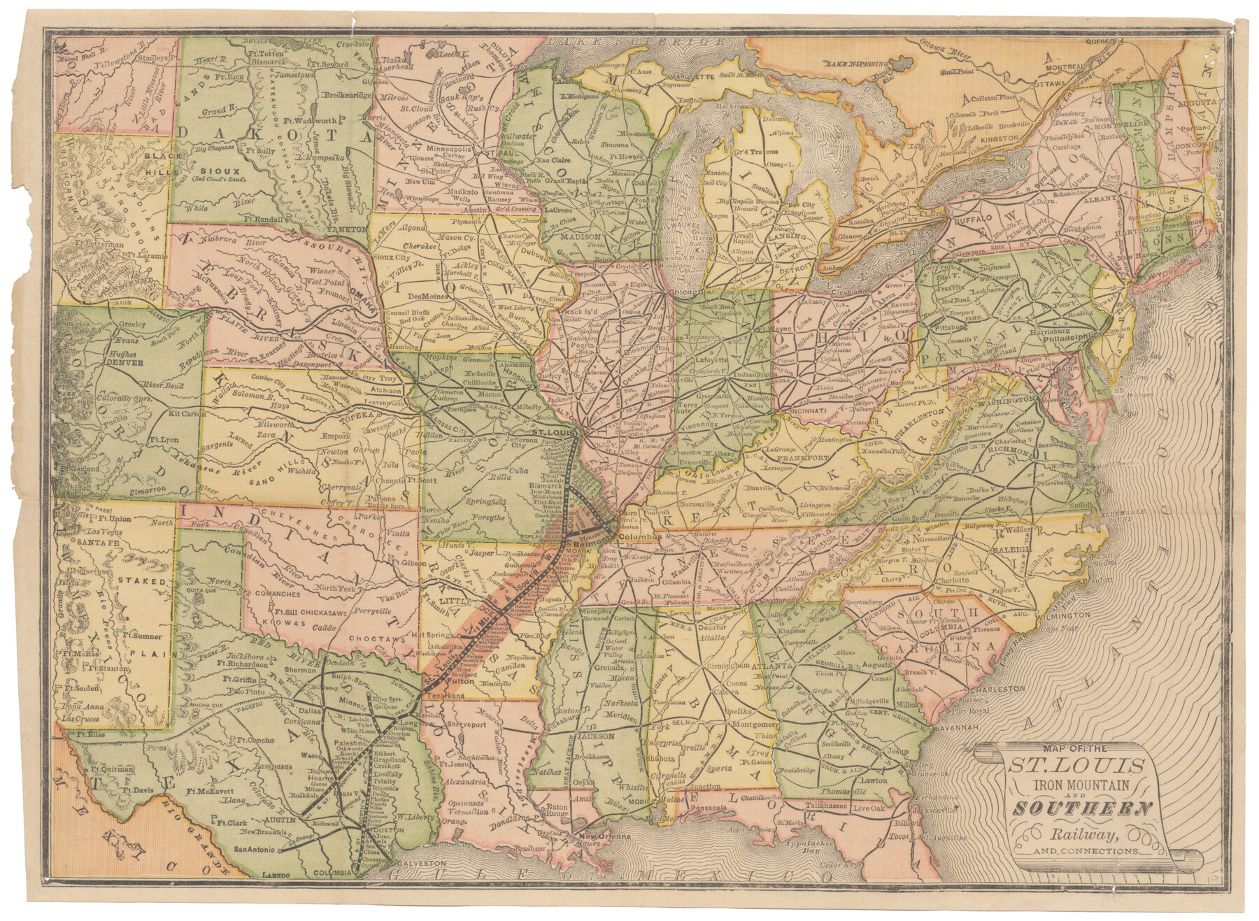
Map of the St. Louis, Iron Mountain and Southern Railway, and connections
-
Map/Doc
95786
-
Collection
Cobb Digital Map Collection
-
Object Dates
[1880 ca.] (Creation Date)
-
Subjects
Railroads
-
Height x Width
10.5 x 14.4 inches
26.7 x 36.6 cm
-
Medium
digital image
-
Comments
Courtesy of John & Diana Cobb.
Part of: Cobb Digital Map Collection
Texas - the Land of Plenty and Promise where the People Combine the Culture of the East with the Vision of the West and the Energy of the North with the Hospitality of the South

Print $20.00
- Digital $50.00
Texas - the Land of Plenty and Promise where the People Combine the Culture of the East with the Vision of the West and the Energy of the North with the Hospitality of the South
1937
Size 7.2 x 10.5 inches
Map/Doc 96596
[Map of North Carolina and South Carolina]
![96621, [Map of North Carolina and South Carolina], Cobb Digital Map Collection](https://historictexasmaps.com/wmedia_w700/maps/96621.tif.jpg)
Print $20.00
- Digital $50.00
[Map of North Carolina and South Carolina]
1869
Size 8.9 x 9.2 inches
Map/Doc 96621
A Geographically Correct County Map of States Traversed by the St. Louis, Iron Mountain & Southern Railway and its Connections

Print $20.00
- Digital $50.00
A Geographically Correct County Map of States Traversed by the St. Louis, Iron Mountain & Southern Railway and its Connections
1877
Size 18.5 x 16.1 inches
Map/Doc 95782
Houston - Where Seventeen Railroads Meet the Sea

Houston - Where Seventeen Railroads Meet the Sea
1913
Size 6.1 x 8.2 inches
Map/Doc 97069
Louisiana and Texas for the Winter Tourist

Louisiana and Texas for the Winter Tourist
1911
Map/Doc 96716
Map of Texas with population and location of principal towns and cities according to latest reliable statistics

Print $20.00
- Digital $50.00
Map of Texas with population and location of principal towns and cities according to latest reliable statistics
1908
Size 18.6 x 20.5 inches
Map/Doc 95872


A Geographically Correct Map of the State of Texas

Print $20.00
- Digital $50.00
A Geographically Correct Map of the State of Texas
1878
Size 19.5 x 21.0 inches
Map/Doc 95757
Rand, McNally & Co.'s Texas

Print $20.00
- Digital $50.00
Rand, McNally & Co.'s Texas
1901
Size 21.3 x 28.2 inches
Map/Doc 95844
A Few Things About Rice as grown on line of Southern Pacific in Texas and Louisiana

A Few Things About Rice as grown on line of Southern Pacific in Texas and Louisiana
1904
Map/Doc 96723

You may also like
Hidalgo County Working Sketch 1

Print $20.00
- Digital $50.00
Hidalgo County Working Sketch 1
1939
Size 24.8 x 21.4 inches
Map/Doc 66178
[Plat of Trinity River w/ Midstream Profile in Liberty County by US Government 1899]
![65337, [Plat of Trinity River w/ Midstream Profile in Liberty County by US Government 1899], General Map Collection](https://historictexasmaps.com/wmedia_w700/maps/65337.tif.jpg)
Print $20.00
- Digital $50.00
[Plat of Trinity River w/ Midstream Profile in Liberty County by US Government 1899]
1899
Size 12.3 x 16.7 inches
Map/Doc 65337
Roberts County Working Sketch 35

Print $20.00
- Digital $50.00
Roberts County Working Sketch 35
1978
Size 26.7 x 22.5 inches
Map/Doc 63561
Jefferson County Rolled Sketch 21

Print $20.00
- Digital $50.00
Jefferson County Rolled Sketch 21
Size 12.0 x 12.1 inches
Map/Doc 6387
DeWitt County Working Sketch 13

Print $20.00
- Digital $50.00
DeWitt County Working Sketch 13
1986
Size 37.6 x 40.9 inches
Map/Doc 68603
Located Line of the Panhandle & Gulf Ry. Through State Lands, Public School and University, in Crockett County, Texas

Print $20.00
- Digital $50.00
Located Line of the Panhandle & Gulf Ry. Through State Lands, Public School and University, in Crockett County, Texas
1904
Size 12.2 x 27.3 inches
Map/Doc 64287
Shelby County Rolled Sketch 4

Print $20.00
- Digital $50.00
Shelby County Rolled Sketch 4
1942
Size 36.4 x 43.2 inches
Map/Doc 9920
Moore County Working Sketch Graphic Index

Print $20.00
- Digital $50.00
Moore County Working Sketch Graphic Index
1932
Size 41.3 x 39.0 inches
Map/Doc 76648
Topographic Map, Low Rent Housing Project Texas 18-1, Housing Authority of the City of Lubbock (Plan No. 2)

Print $20.00
- Digital $50.00
Topographic Map, Low Rent Housing Project Texas 18-1, Housing Authority of the City of Lubbock (Plan No. 2)
1941
Size 42.4 x 27.2 inches
Map/Doc 92757
San Patricio County Rolled Sketch 37

Print $127.00
- Digital $50.00
San Patricio County Rolled Sketch 37
Size 10.3 x 15.2 inches
Map/Doc 48888
McMullen County Sketch File 25

Print $6.00
- Digital $50.00
McMullen County Sketch File 25
1877
Size 8.5 x 14.2 inches
Map/Doc 31383
Webb County Sketch File 49

Print $20.00
- Digital $50.00
Webb County Sketch File 49
1939
Size 20.7 x 21.5 inches
Map/Doc 12647