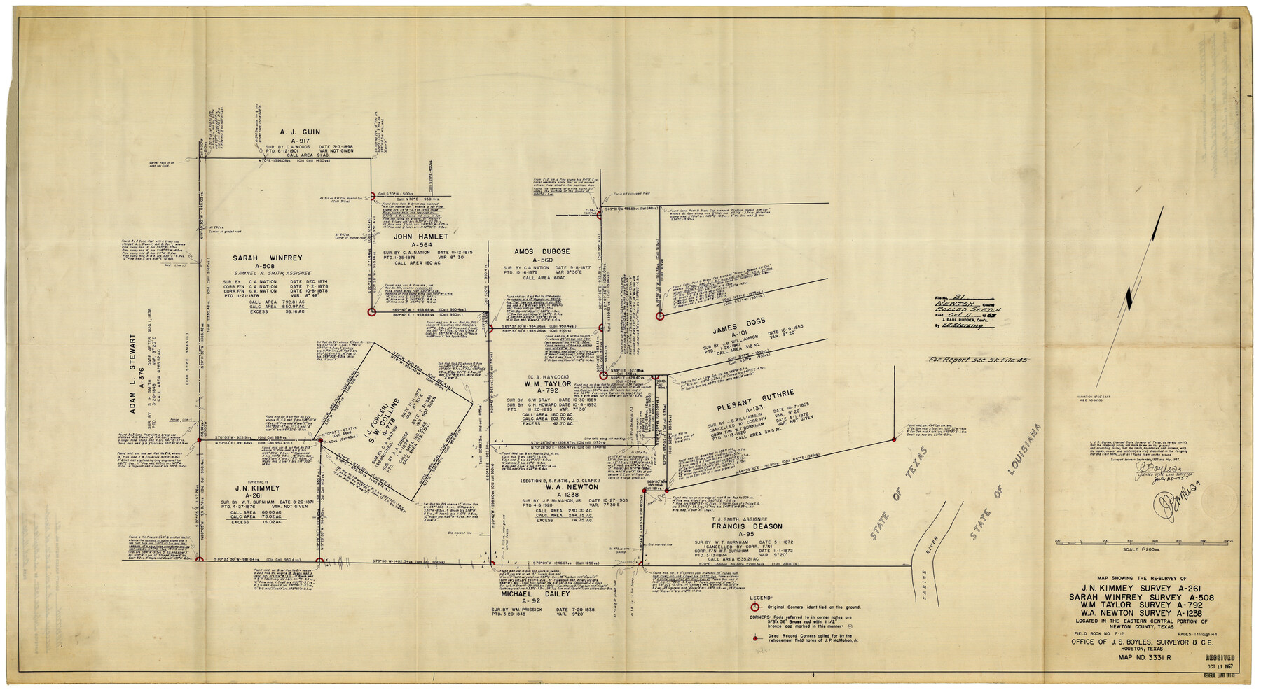
Newton County Rolled Sketch 21
Map showing the re-survey of J.N. Kimmey survey A-261, Sarah Winfrey survey A-508, W.M. Taylor survey A-792, W.A. Newton survey A-1238 located in the eastern central portion of Newton County, Texas
-
Map/Doc
9582
-
Collection
General Map Collection
-
Object Dates
7/25/1957 (Creation Date)
10/11/1957 (File Date)
-
People and Organizations
J.S. Boyles (Surveyor/Engineer)
-
Counties
Newton
-
Subjects
Surveying Rolled Sketch
-
Height x Width
29.9 x 52.5 inches
76.0 x 133.4 cm
-
Medium
blueprint/diazo
-
Scale
1" = 200 varas
Related maps
Newton County Sketch File 45

Print $12.00
- Digital $50.00
Newton County Sketch File 45
1957
Size 14.1 x 8.7 inches
Map/Doc 32445
Part of: General Map Collection
Castro County Working Sketch 5

Print $20.00
- Digital $50.00
Castro County Working Sketch 5
1943
Size 11.9 x 18.3 inches
Map/Doc 67900
Flight Mission No. BRA-8M, Frame 73, Jefferson County

Print $20.00
- Digital $50.00
Flight Mission No. BRA-8M, Frame 73, Jefferson County
1953
Size 18.7 x 22.3 inches
Map/Doc 85593
Jefferson Co.

Print $20.00
- Digital $50.00
Jefferson Co.
1978
Size 47.0 x 41.1 inches
Map/Doc 77329
Flight Mission No. DAG-26K, Frame 80, Matagorda County

Print $20.00
- Digital $50.00
Flight Mission No. DAG-26K, Frame 80, Matagorda County
1953
Size 18.5 x 22.3 inches
Map/Doc 86585
Fractional Township No. 1N and Township No. 2N R. No. 1E, Deaf Smith and Parmer Counties comprising Capitol Leagues 436, 437, 454, and 455 and parts of Capitol Leagues 433, 434, 435, 438, 453, 456, 457 and 458

Print $20.00
- Digital $50.00
Fractional Township No. 1N and Township No. 2N R. No. 1E, Deaf Smith and Parmer Counties comprising Capitol Leagues 436, 437, 454, and 455 and parts of Capitol Leagues 433, 434, 435, 438, 453, 456, 457 and 458
1906
Size 27.1 x 22.4 inches
Map/Doc 93965
Marion County Working Sketch Graphic Index, Sheet 2 (Sketches 27 to Most Recent)

Print $20.00
- Digital $50.00
Marion County Working Sketch Graphic Index, Sheet 2 (Sketches 27 to Most Recent)
1943
Size 26.5 x 44.9 inches
Map/Doc 76630
Brewster County Rolled Sketch 124

Print $20.00
- Digital $50.00
Brewster County Rolled Sketch 124
1975
Size 15.8 x 13.2 inches
Map/Doc 5299
Wise County Sketch File 46

Print $20.00
- Digital $50.00
Wise County Sketch File 46
Size 24.7 x 18.5 inches
Map/Doc 12701
Anderson County Working Sketch 27

Print $20.00
- Digital $50.00
Anderson County Working Sketch 27
1959
Size 20.8 x 36.0 inches
Map/Doc 67027
[Atchison, Topeka & Santa Fe from Paisano to south of Plata]
![64712, [Atchison, Topeka & Santa Fe from Paisano to south of Plata], General Map Collection](https://historictexasmaps.com/wmedia_w700/maps/64712-1.tif.jpg)
Print $40.00
- Digital $50.00
[Atchison, Topeka & Santa Fe from Paisano to south of Plata]
Size 32.3 x 121.5 inches
Map/Doc 64712
Refugio County Rolled Sketch 6

Print $20.00
- Digital $50.00
Refugio County Rolled Sketch 6
1892
Size 28.7 x 29.2 inches
Map/Doc 7507
Flight Mission No. CRE-1R, Frame 132, Jackson County

Print $20.00
- Digital $50.00
Flight Mission No. CRE-1R, Frame 132, Jackson County
1956
Size 16.2 x 16.0 inches
Map/Doc 85340
You may also like
Presidio County Working Sketch 56

Print $20.00
- Digital $50.00
Presidio County Working Sketch 56
1955
Size 13.9 x 22.0 inches
Map/Doc 71733
Laneer vs. Bivins, Potter County, Texas

Print $20.00
- Digital $50.00
Laneer vs. Bivins, Potter County, Texas
Size 21.1 x 18.7 inches
Map/Doc 93098
FT. W. & R. G. Ry. Right of Way Map, Winchell to Brady, McCulloch County, Texas

Print $40.00
- Digital $50.00
FT. W. & R. G. Ry. Right of Way Map, Winchell to Brady, McCulloch County, Texas
1918
Size 38.0 x 121.9 inches
Map/Doc 61410
Mason County Sketch File 19

Print $20.00
- Digital $50.00
Mason County Sketch File 19
1901
Size 19.1 x 20.9 inches
Map/Doc 12036
Crosby County Sketch File 34

Print $4.00
- Digital $50.00
Crosby County Sketch File 34
1892
Size 11.3 x 8.9 inches
Map/Doc 20104
Baylor County Sketch File 7

Print $4.00
- Digital $50.00
Baylor County Sketch File 7
Size 6.7 x 10.2 inches
Map/Doc 14135
Soil Map - Ohio-Michigan, Toledo Set

Print $20.00
- Digital $50.00
Soil Map - Ohio-Michigan, Toledo Set
1902
Size 21.4 x 30.5 inches
Map/Doc 3023
Bailey County Sketch File 21

Print $14.00
- Digital $50.00
Bailey County Sketch File 21
Size 11.3 x 8.8 inches
Map/Doc 13990
Map of Nacogdoches County

Print $20.00
- Digital $50.00
Map of Nacogdoches County
1881
Size 24.1 x 21.5 inches
Map/Doc 4605
The Judicial District/County of Madison. Created, February 2, 1842

Print $20.00
The Judicial District/County of Madison. Created, February 2, 1842
2020
Size 18.2 x 21.7 inches
Map/Doc 96333
Gregg County Rolled Sketch RG

Print $20.00
- Digital $50.00
Gregg County Rolled Sketch RG
Size 44.4 x 36.0 inches
Map/Doc 9025
Kimble County Working Sketch 52

Print $20.00
- Digital $50.00
Kimble County Working Sketch 52
1953
Size 31.1 x 16.7 inches
Map/Doc 70120