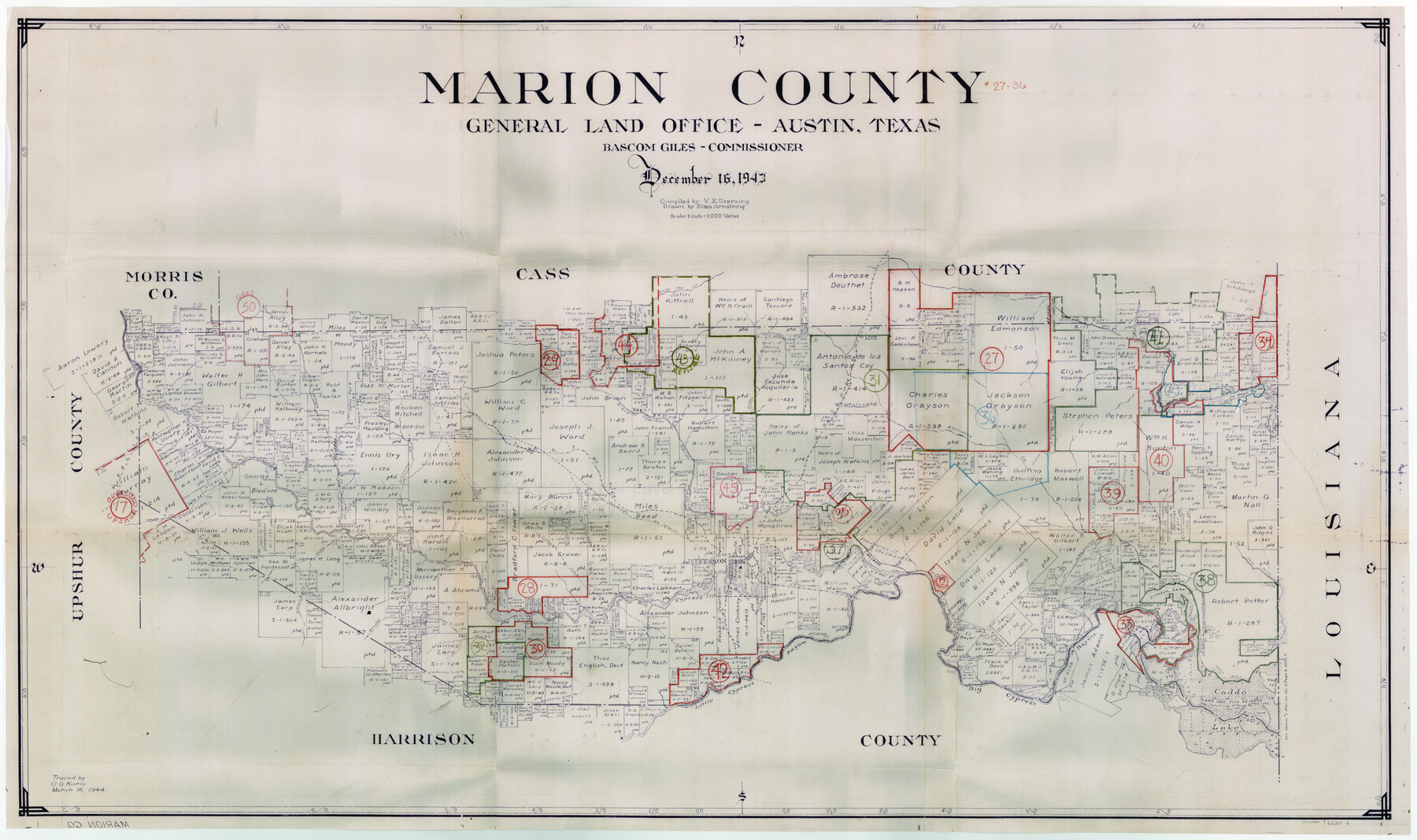
Marion County Working Sketch Graphic Index, Sheet 2 (Sketches 27 to Most Recent)
-
Map/Doc
76630
-
Collection
General Map Collection
-
Object Dates
12/16/1943 (Creation Date)
-
People and Organizations
Victor E. Sterzing (Compiler)
Eltea Armstrong (Draftsman)
-
Counties
Marion
-
Subjects
County Surveying Working Sketch
-
Height x Width
26.5 x 44.9 inches
67.3 x 114.1 cm
-
Scale
1" = 2000 varas
Part of: General Map Collection
Motley County Boundary File 2c

Print $34.00
- Digital $50.00
Motley County Boundary File 2c
Size 14.2 x 8.7 inches
Map/Doc 57533
Map of Nacogdoches County

Print $40.00
- Digital $50.00
Map of Nacogdoches County
1839
Size 83.6 x 43.2 inches
Map/Doc 93370
Travis County Working Sketch 49

Print $20.00
- Digital $50.00
Travis County Working Sketch 49
1984
Size 33.9 x 37.2 inches
Map/Doc 69433
Road Guide of Central Texas, Colorado River, Highland Lakes and Hill Country

Print $20.00
- Digital $50.00
Road Guide of Central Texas, Colorado River, Highland Lakes and Hill Country
1947
Size 18.0 x 21.7 inches
Map/Doc 60293
Marion County Working Sketch 22

Print $20.00
- Digital $50.00
Marion County Working Sketch 22
1960
Size 34.3 x 27.5 inches
Map/Doc 70798
United States Base Map

Print $20.00
- Digital $50.00
United States Base Map
1916
Size 19.2 x 29.5 inches
Map/Doc 69653
S.P.O. Co. No. 7, State Submerged Tract No. 12, Laguna Madre, Nueces Co., Texas

Print $20.00
- Digital $50.00
S.P.O. Co. No. 7, State Submerged Tract No. 12, Laguna Madre, Nueces Co., Texas
1937
Size 27.9 x 27.4 inches
Map/Doc 3026
Loving County Working Sketch 24

Print $40.00
- Digital $50.00
Loving County Working Sketch 24
1952
Size 15.8 x 63.3 inches
Map/Doc 70658
Aransas County Sketch File 14

Print $36.00
- Digital $50.00
Aransas County Sketch File 14
1891
Size 14.0 x 8.5 inches
Map/Doc 13128
Shelby County Rolled Sketch 21

Print $20.00
- Digital $50.00
Shelby County Rolled Sketch 21
Size 17.0 x 22.3 inches
Map/Doc 93285
Duval County Working Sketch 8

Print $20.00
- Digital $50.00
Duval County Working Sketch 8
1935
Size 18.6 x 29.2 inches
Map/Doc 68721
Sabine Bank to East Bay including Heald Bank

Print $20.00
- Digital $50.00
Sabine Bank to East Bay including Heald Bank
1946
Size 44.8 x 33.9 inches
Map/Doc 69845
You may also like
Leon County Rolled Sketch 10

Print $20.00
- Digital $50.00
Leon County Rolled Sketch 10
1962
Size 30.9 x 37.2 inches
Map/Doc 6598
Hays County Working Sketch 16

Print $20.00
- Digital $50.00
Hays County Working Sketch 16
1970
Size 34.3 x 38.0 inches
Map/Doc 66090
[Surveying Sketch of Northern Portion of Hutchinson County]
![5065, [Surveying Sketch of Northern Portion of Hutchinson County], Maddox Collection](https://historictexasmaps.com/wmedia_w700/maps/5065.tif.jpg)
Print $20.00
- Digital $50.00
[Surveying Sketch of Northern Portion of Hutchinson County]
1890
Size 26.5 x 42.5 inches
Map/Doc 5065
San Patricio County Working Sketch 8

Print $20.00
- Digital $50.00
San Patricio County Working Sketch 8
1936
Size 26.9 x 21.5 inches
Map/Doc 63770
Montague County Sketch File 27

Print $20.00
- Digital $50.00
Montague County Sketch File 27
1954
Size 15.8 x 22.5 inches
Map/Doc 12109
Flight Mission No. DIX-10P, Frame 178, Aransas County

Print $20.00
- Digital $50.00
Flight Mission No. DIX-10P, Frame 178, Aransas County
1956
Size 18.5 x 22.2 inches
Map/Doc 83968
Culberson County Rolled Sketch 52

Print $20.00
- Digital $50.00
Culberson County Rolled Sketch 52
Size 19.1 x 24.7 inches
Map/Doc 5672
Flight Mission No. DQN-1K, Frame 49, Calhoun County

Print $20.00
- Digital $50.00
Flight Mission No. DQN-1K, Frame 49, Calhoun County
1953
Size 18.6 x 22.4 inches
Map/Doc 84149
The Republic County of Bowie. Created, December 17, 1840

Print $20.00
The Republic County of Bowie. Created, December 17, 1840
2020
Size 19.5 x 21.7 inches
Map/Doc 96102
Flight Mission No. DAG-18K, Frame 73, Matagorda County

Print $20.00
- Digital $50.00
Flight Mission No. DAG-18K, Frame 73, Matagorda County
1952
Size 18.5 x 22.2 inches
Map/Doc 86366
E. B. Shipp Irrigated Farm East Part Section 32, Block JS

Print $3.00
- Digital $50.00
E. B. Shipp Irrigated Farm East Part Section 32, Block JS
Size 9.3 x 16.7 inches
Map/Doc 92298
Tarrant County Working Sketch 24

Print $20.00
- Digital $50.00
Tarrant County Working Sketch 24
2003
Size 26.0 x 34.9 inches
Map/Doc 78642