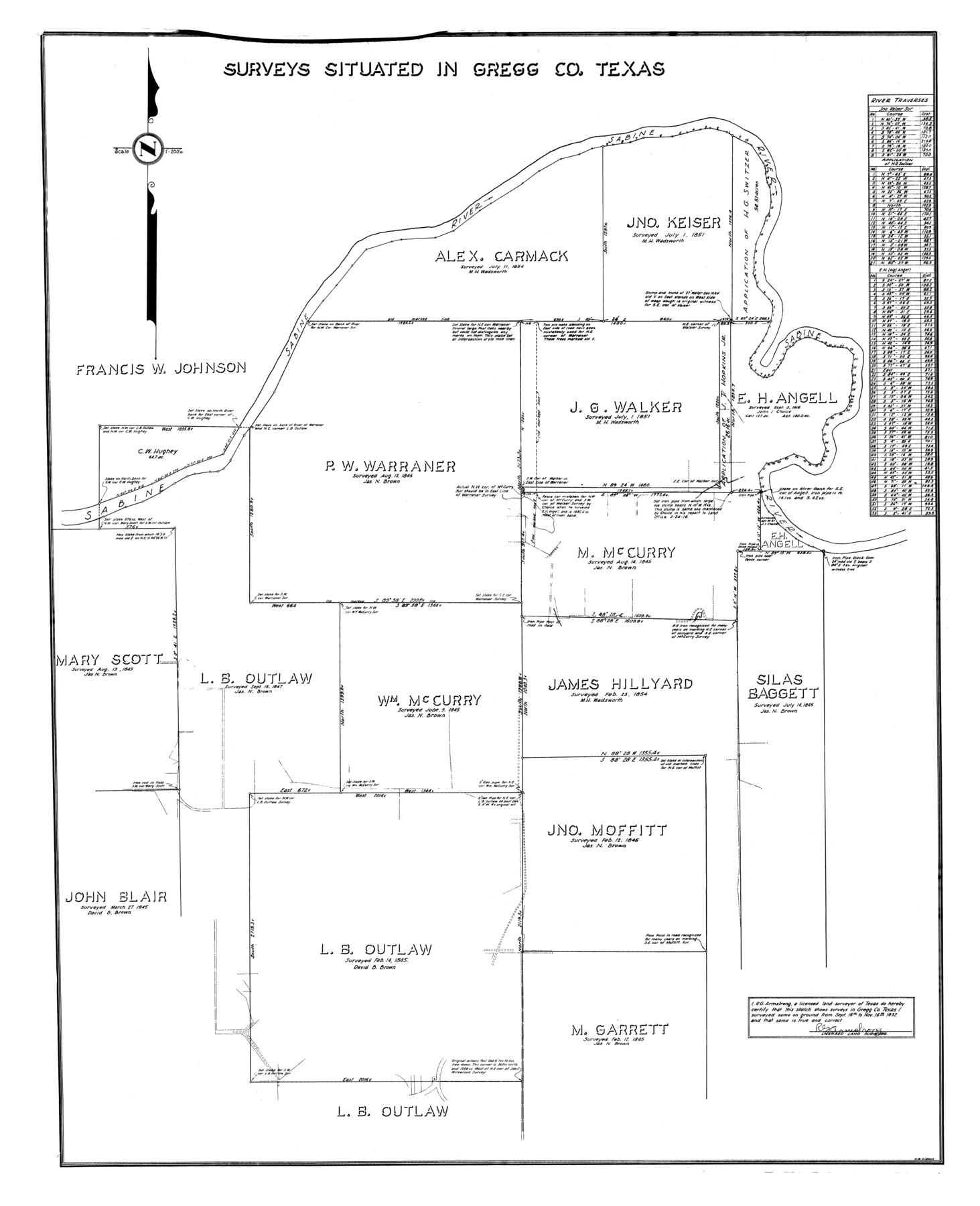
Gregg County Rolled Sketch RG
Surveys situated in Gregg Co., Texas
-
Map/Doc
9025
-
Collection
General Map Collection
-
Object Dates
1932/11/16 (Survey Date)
-
People and Organizations
R.G. Armstrong (Surveyor/Engineer)
-
Counties
Gregg
-
Subjects
Surveying Rolled Sketch
-
Height x Width
44.4 x 36.0 inches
112.8 x 91.4 cm
-
Scale
1" = 200 varas
Part of: General Map Collection
Bandera County Boundary File 7

Print $14.00
- Digital $50.00
Bandera County Boundary File 7
Size 12.7 x 8.1 inches
Map/Doc 50306
Robertson Co.

Print $20.00
- Digital $50.00
Robertson Co.
1889
Size 43.7 x 39.9 inches
Map/Doc 63003
Coke County Rolled Sketch 15

Print $40.00
- Digital $50.00
Coke County Rolled Sketch 15
1949
Size 48.1 x 46.5 inches
Map/Doc 8628
Survey of The Rio Grande Roma to the Gulf of Mexico

Survey of The Rio Grande Roma to the Gulf of Mexico
Map/Doc 81739
Sketch for Mineral Application 33721 - 33725 Incl (Attorney General) - Map of Padre Island - Cameron, Willacy, Kleberg, Nueces and Kenedy Counties.

Print $20.00
- Digital $50.00
Sketch for Mineral Application 33721 - 33725 Incl (Attorney General) - Map of Padre Island - Cameron, Willacy, Kleberg, Nueces and Kenedy Counties.
Size 43.3 x 23.1 inches
Map/Doc 65663
Cottle County Sketch File 14

Print $50.00
- Digital $50.00
Cottle County Sketch File 14
1918
Size 11.3 x 8.8 inches
Map/Doc 19491
Red River County Working Sketch 35

Print $20.00
- Digital $50.00
Red River County Working Sketch 35
1964
Size 34.9 x 41.0 inches
Map/Doc 72018
Galveston County NRC Article 33.136 Sketch 35

Print $42.00
- Digital $50.00
Galveston County NRC Article 33.136 Sketch 35
2005
Size 24.3 x 36.6 inches
Map/Doc 83406
Andrews County Working Sketch 29

Print $20.00
- Digital $50.00
Andrews County Working Sketch 29
1988
Size 25.9 x 25.8 inches
Map/Doc 67075
Presidio County Rolled Sketch 71

Print $20.00
- Digital $50.00
Presidio County Rolled Sketch 71
1941
Size 31.7 x 42.9 inches
Map/Doc 7361
Burnet County Sketch File 18

Print $4.00
- Digital $50.00
Burnet County Sketch File 18
1873
Size 8.3 x 6.5 inches
Map/Doc 16708
Flight Mission No. DQN-6K, Frame 9, Calhoun County

Print $20.00
- Digital $50.00
Flight Mission No. DQN-6K, Frame 9, Calhoun County
1953
Size 18.5 x 22.1 inches
Map/Doc 84431
You may also like
Comal County Sketch File 6

Print $6.00
- Digital $50.00
Comal County Sketch File 6
Size 10.3 x 8.1 inches
Map/Doc 19008
Flight Mission No. BRA-7M, Frame 35, Jefferson County

Print $20.00
- Digital $50.00
Flight Mission No. BRA-7M, Frame 35, Jefferson County
1953
Size 18.7 x 22.4 inches
Map/Doc 85486
Glasscock County Sketch File 27

Print $10.00
- Digital $50.00
Glasscock County Sketch File 27
1989
Size 11.3 x 8.8 inches
Map/Doc 24206
Starr County Working Sketch 4

Print $20.00
- Digital $50.00
Starr County Working Sketch 4
1927
Size 38.5 x 28.9 inches
Map/Doc 63920
Gaines County Working Sketch 7

Print $20.00
- Digital $50.00
Gaines County Working Sketch 7
1940
Size 16.5 x 38.5 inches
Map/Doc 69307
Harrison County Working Sketch 21

Print $40.00
- Digital $50.00
Harrison County Working Sketch 21
1982
Size 37.6 x 49.9 inches
Map/Doc 66041
Flight Mission No. DAH-9M, Frame 83, Orange County

Print $20.00
- Digital $50.00
Flight Mission No. DAH-9M, Frame 83, Orange County
1953
Size 18.5 x 22.3 inches
Map/Doc 86847
Jackson County Rolled Sketch 5

Print $20.00
- Digital $50.00
Jackson County Rolled Sketch 5
1914
Size 22.3 x 20.2 inches
Map/Doc 6340
Brewster County Sketch File N-24

Print $40.00
- Digital $50.00
Brewster County Sketch File N-24
Size 23.9 x 16.4 inches
Map/Doc 10970
Throckmorton County Boundary File 6

Print $6.00
- Digital $50.00
Throckmorton County Boundary File 6
Size 11.4 x 8.9 inches
Map/Doc 59292
Flight Mission No. DQN-2K, Frame 37, Calhoun County

Print $20.00
- Digital $50.00
Flight Mission No. DQN-2K, Frame 37, Calhoun County
1953
Size 18.4 x 22.2 inches
Map/Doc 84242
Travis County Rolled Sketch 42

Print $20.00
- Digital $50.00
Travis County Rolled Sketch 42
Size 25.2 x 25.7 inches
Map/Doc 8040