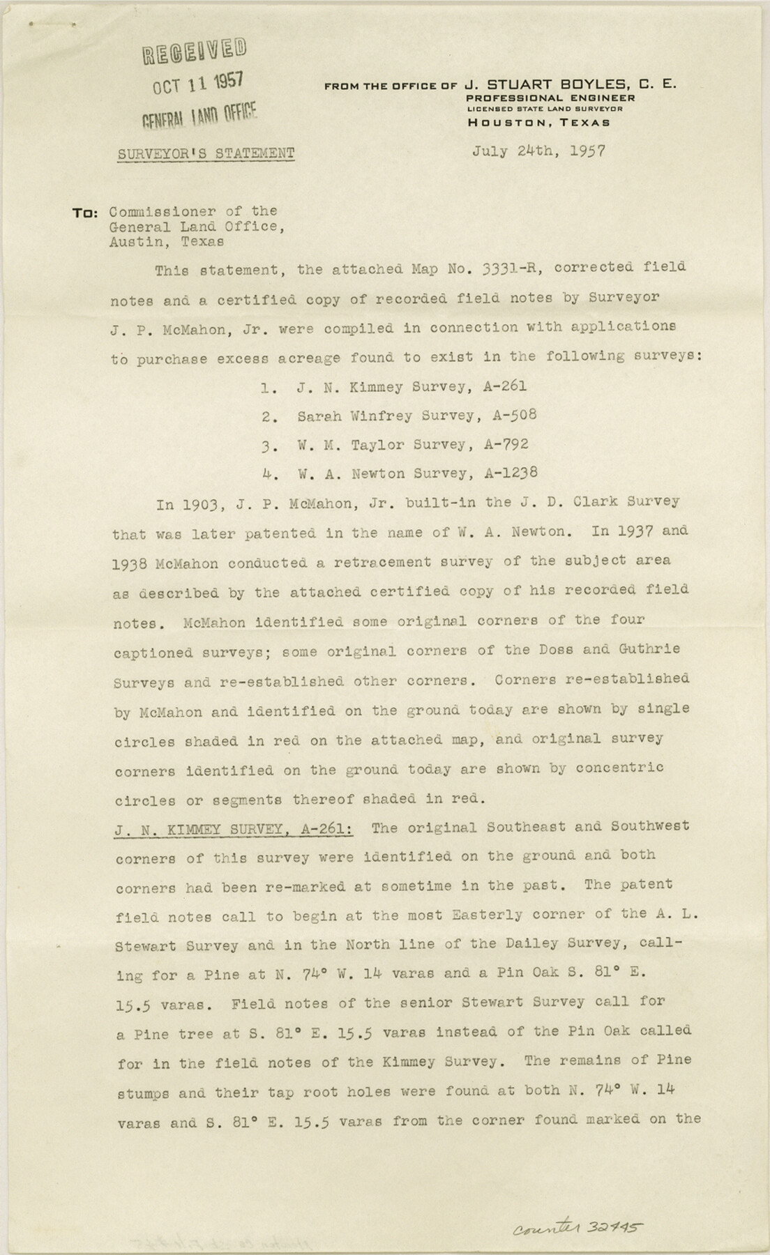
Newton County Sketch File 45
[Report of a survey of area southeast of Newton]
-
Map/Doc
32445
-
Collection
General Map Collection
-
Object Dates
7/24/1957 (Creation Date)
10/11/1957 (File Date)
-
People and Organizations
J.S. Boyles (Surveyor/Engineer)
-
Counties
Newton
-
Subjects
Surveying Sketch File
-
Height x Width
14.1 x 8.7 inches
35.8 x 22.1 cm
-
Medium
paper, print
-
Comments
See Newton County Rolled Sketch 21 (9582).
Related maps
Newton County Rolled Sketch 21

Print $40.00
- Digital $50.00
Newton County Rolled Sketch 21
1957
Size 29.9 x 52.5 inches
Map/Doc 9582
Part of: General Map Collection
Denton County Rolled Sketch 5

Print $20.00
- Digital $50.00
Denton County Rolled Sketch 5
1973
Size 31.9 x 36.6 inches
Map/Doc 8776
Brewster County Sketch File 18

Print $8.00
- Digital $50.00
Brewster County Sketch File 18
1942
Size 13.8 x 7.6 inches
Map/Doc 15813
Aransas County Rolled Sketch 1

Print $40.00
- Digital $50.00
Aransas County Rolled Sketch 1
1930
Size 12.5 x 50.0 inches
Map/Doc 8915
Gray's Geological Map of the United States

Print $20.00
- Digital $50.00
Gray's Geological Map of the United States
1873
Size 17.6 x 28.8 inches
Map/Doc 95174
Newton County Sketch File 42

Print $39.00
- Digital $50.00
Newton County Sketch File 42
1936
Size 13.2 x 8.7 inches
Map/Doc 32425
Nolan County Sketch File 16

Print $20.00
- Digital $50.00
Nolan County Sketch File 16
1938
Size 18.9 x 23.4 inches
Map/Doc 42166
Bee County Sketch File 7

Print $8.00
- Digital $50.00
Bee County Sketch File 7
1873
Size 10.1 x 8.0 inches
Map/Doc 14275

Dickens County Sketch File 33

Print $10.00
- Digital $50.00
Dickens County Sketch File 33
1947
Size 14.5 x 9.1 inches
Map/Doc 21025
El Paso County Sketch File 3

Print $98.00
- Digital $50.00
El Paso County Sketch File 3
1879
Size 13.0 x 8.3 inches
Map/Doc 21909
Map of Giddings

Print $20.00
- Digital $50.00
Map of Giddings
1940
Size 16.5 x 21.2 inches
Map/Doc 2210
Upton County Rolled Sketch 34

Print $20.00
- Digital $50.00
Upton County Rolled Sketch 34
1951
Size 34.4 x 34.3 inches
Map/Doc 10050
You may also like
A Topographical Map of the Government Tract adjoining the City of Austin

Print $20.00
- Digital $50.00
A Topographical Map of the Government Tract adjoining the City of Austin
1840
Size 41.9 x 37.8 inches
Map/Doc 2180
Goliad County Sketch File 6

Print $2.00
- Digital $50.00
Goliad County Sketch File 6
1857
Size 8.8 x 4.9 inches
Map/Doc 24220
Freestone County

Print $20.00
- Digital $50.00
Freestone County
1918
Size 46.8 x 39.8 inches
Map/Doc 4702
Goliad County Rolled Sketch 5

Print $20.00
- Digital $50.00
Goliad County Rolled Sketch 5
1956
Size 26.5 x 29.5 inches
Map/Doc 6025
Webb County Boundary File 3a

Print $10.00
- Digital $50.00
Webb County Boundary File 3a
Size 14.2 x 8.7 inches
Map/Doc 59753
Cameron County Rolled Sketch 11A

Print $20.00
- Digital $50.00
Cameron County Rolled Sketch 11A
1934
Size 30.0 x 37.0 inches
Map/Doc 11048
Fractional Township No. 9 South Range No. 24 East of the Indian Meridian, Indian Territory

Print $20.00
- Digital $50.00
Fractional Township No. 9 South Range No. 24 East of the Indian Meridian, Indian Territory
1898
Size 19.2 x 24.3 inches
Map/Doc 75241
The Republic County of Matagorda. January 1, 1838

Print $20.00
The Republic County of Matagorda. January 1, 1838
2020
Size 21.0 x 21.7 inches
Map/Doc 96216
[Sketch Between Hemphill County and Oklahoma]
![89635, [Sketch Between Hemphill County and Oklahoma], Twichell Survey Records](https://historictexasmaps.com/wmedia_w700/maps/89635-1.tif.jpg)
Print $40.00
- Digital $50.00
[Sketch Between Hemphill County and Oklahoma]
Size 62.0 x 8.0 inches
Map/Doc 89635
Terrell County Working Sketch 49

Print $20.00
- Digital $50.00
Terrell County Working Sketch 49
1958
Size 22.2 x 37.5 inches
Map/Doc 62142
[Sketch of surveys in the vicinity of sections 171 and 172 along Pedernales]
![91880, [Sketch of surveys in the vicinity of sections 171 and 172 along Pedernales], Twichell Survey Records](https://historictexasmaps.com/wmedia_w700/maps/91880-1.tif.jpg)
Print $20.00
- Digital $50.00
[Sketch of surveys in the vicinity of sections 171 and 172 along Pedernales]
Size 15.8 x 14.3 inches
Map/Doc 91880
[R. M. Thompson Block T2 and John H. Stephens Block S2 Conflict]
![91056, [R. M. Thompson Block T2 and John H. Stephens Block S2 Conflict], Twichell Survey Records](https://historictexasmaps.com/wmedia_w700/maps/91056-1.tif.jpg)
Print $20.00
- Digital $50.00
[R. M. Thompson Block T2 and John H. Stephens Block S2 Conflict]
Size 20.9 x 30.6 inches
Map/Doc 91056