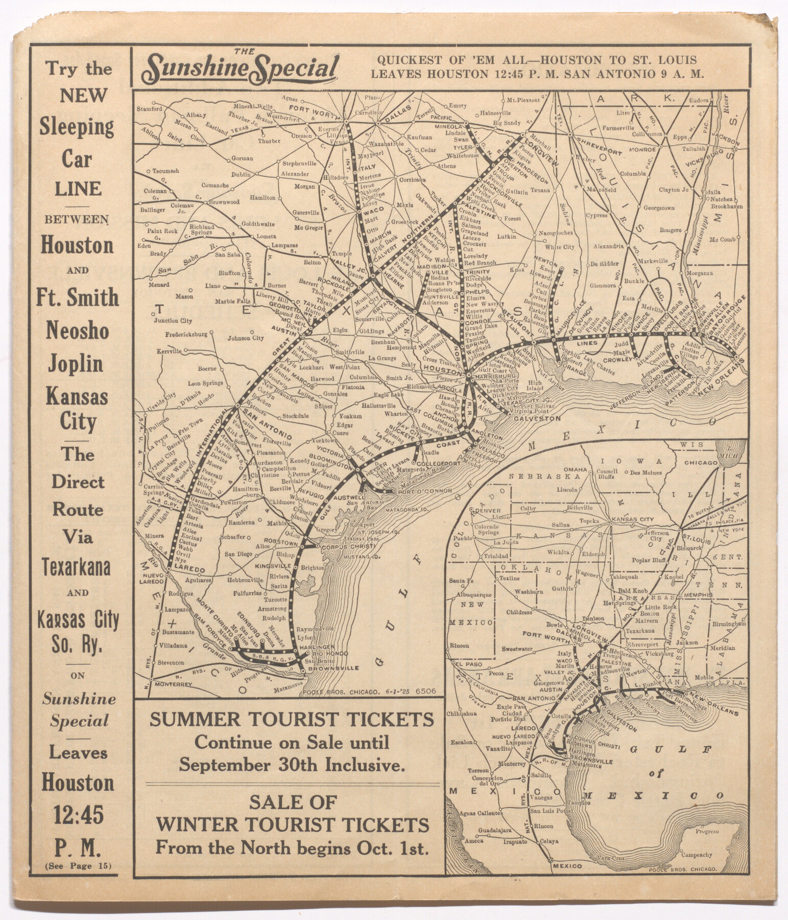
The Sunshine Special - Quickest of 'em all - Hosuton to St. Louis leaves Houston 12:45 p.m. San Antonio 9 a.m.
International - Great Northern Railroad Company Time Tables
-
Map/Doc
95780
-
Collection
Cobb Digital Map Collection
-
Object Dates
6/1/1925 (Creation Date)
-
People and Organizations
Poole Bros. (Printer)
-
Subjects
Railroads State of Texas
-
Height x Width
9.0 x 7.7 inches
22.9 x 19.6 cm
-
Medium
digital image
-
Comments
Courtesy of John & Diana Cobb.
To view full booklet containing map and time tables, click "Download PDF" link above.
Part of: Cobb Digital Map Collection
County and Railroad Map of Texas

Print $20.00
- Digital $50.00
County and Railroad Map of Texas
1871
Size 16.7 x 15.5 inches
Map/Doc 95752
Map of Texas with population and location of principal towns and cities according to latest reliable statistics

Print $20.00
- Digital $50.00
Map of Texas with population and location of principal towns and cities according to latest reliable statistics
1913
Size 18.3 x 20.2 inches
Map/Doc 95879

Map of Texas with population and location of principal towns and cities according to latest reliable statistics

Print $20.00
- Digital $50.00
Map of Texas with population and location of principal towns and cities according to latest reliable statistics
1908
Size 18.6 x 20.5 inches
Map/Doc 95872
The Brownsville District of the Famous Lower Rio Grande Valley - The Texas Tropics

The Brownsville District of the Famous Lower Rio Grande Valley - The Texas Tropics
1920
Map/Doc 96732
Scenes Around Carrizo Springs, Texas the Hub of the Winter Garden District

Print $20.00
- Digital $50.00
Scenes Around Carrizo Springs, Texas the Hub of the Winter Garden District
1920
Size 8.8 x 15.5 inches
Map/Doc 96767
Map of the Texas & Pacific Railway and connections

Print $20.00
- Digital $50.00
Map of the Texas & Pacific Railway and connections
1899
Size 17.9 x 36.6 inches
Map/Doc 95765
Texas with population and location of principal towns and cities according to latest reliable statistics

Print $20.00
- Digital $50.00
Texas with population and location of principal towns and cities according to latest reliable statistics
1912
Size 19.0 x 21.2 inches
Map/Doc 95877
Along the Sunset Route, Southern Pacific Lines - Texas and Louisiana

Along the Sunset Route, Southern Pacific Lines - Texas and Louisiana
1947
Map/Doc 96720
New and Correct Map of the Great Rock Island Route - Chicago, Rock Island, & Pacific Railway

Print $20.00
- Digital $50.00
New and Correct Map of the Great Rock Island Route - Chicago, Rock Island, & Pacific Railway
1892
Size 20.0 x 42.2 inches
Map/Doc 95865
MKT - Missouri, Kansas, Texas Lines

Print $20.00
- Digital $50.00
MKT - Missouri, Kansas, Texas Lines
1930
Size 9.1 x 16.1 inches
Map/Doc 95811
Map of the Texas & Pacific Railway and connections

Print $20.00
- Digital $50.00
Map of the Texas & Pacific Railway and connections
1899
Size 17.8 x 36.3 inches
Map/Doc 95766
You may also like
Reagan County Sketch File 2

Print $2.00
- Digital $50.00
Reagan County Sketch File 2
Size 10.8 x 6.6 inches
Map/Doc 34979
Clason's Guide Map Texas and Northern Mexico

Print $20.00
Clason's Guide Map Texas and Northern Mexico
1924
Size 21.3 x 28.4 inches
Map/Doc 76314
Caddo Lake and Subdivision

Print $20.00
- Digital $50.00
Caddo Lake and Subdivision
1918
Size 35.0 x 29.8 inches
Map/Doc 93283
Map of Dimmit County

Print $20.00
- Digital $50.00
Map of Dimmit County
1875
Size 21.9 x 24.0 inches
Map/Doc 3489
[Map of Nacogdoches County]
![93369, [Map of Nacogdoches County], General Map Collection](https://historictexasmaps.com/wmedia_w700/maps/93369-1.tif.jpg)
Print $40.00
- Digital $50.00
[Map of Nacogdoches County]
1840
Size 79.3 x 36.8 inches
Map/Doc 93369
South Part Brewster Co.

Print $40.00
- Digital $50.00
South Part Brewster Co.
Size 35.2 x 49.8 inches
Map/Doc 66724
Panola County Working Sketch 8

Print $20.00
- Digital $50.00
Panola County Working Sketch 8
1943
Map/Doc 71417
Terrell County Working Sketch 20

Print $20.00
- Digital $50.00
Terrell County Working Sketch 20
1934
Size 20.5 x 19.4 inches
Map/Doc 62170
Archer County Sketch File 11

Print $4.00
- Digital $50.00
Archer County Sketch File 11
Size 10.4 x 8.5 inches
Map/Doc 13644
Garza County Sketch File 22

Print $40.00
- Digital $50.00
Garza County Sketch File 22
Size 51.9 x 24.1 inches
Map/Doc 10464
[Map Showing Location and Right of Way of Proposed Groins]
![73623, [Map Showing Location and Right of Way of Proposed Groins], General Map Collection](https://historictexasmaps.com/wmedia_w700/maps/73623-1.tif.jpg)
Print $4.00
- Digital $50.00
[Map Showing Location and Right of Way of Proposed Groins]
Size 13.4 x 24.4 inches
Map/Doc 73623
Northwest Part of Webb County

Print $40.00
- Digital $50.00
Northwest Part of Webb County
1984
Size 43.2 x 52.9 inches
Map/Doc 95669