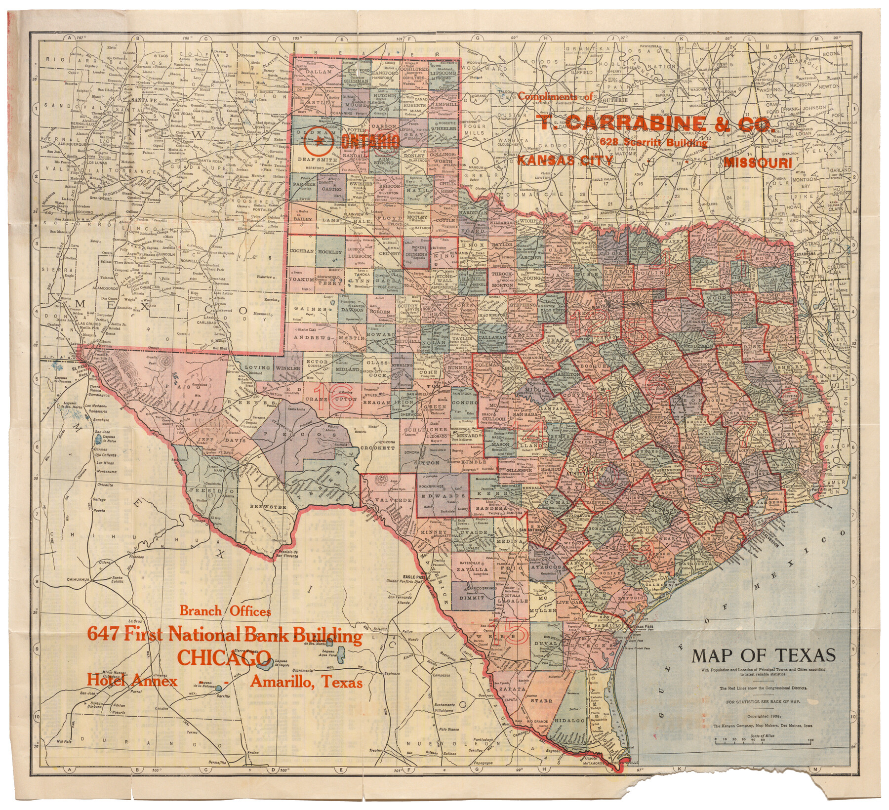
Map of Texas with population and location of principal towns and cities according to latest reliable statistics
-
Map/Doc
95872
-
Collection
Cobb Digital Map Collection
-
Object Dates
1908 (Creation Date)
-
People and Organizations
The Kenyon Company (Publisher)
The Kenyon Company (Printer)
-
Subjects
Railroads State of Texas
-
Height x Width
18.6 x 20.5 inches
47.2 x 52.1 cm
-
Medium
digital image
-
Comments
Map branded by T. Carrabine & Co.
Courtesy of John & Diana Cobb.
To view statistics printed on verso, price list of lots, and original cover in which this map was folded, click "Download PDF" link above.
Part of: Cobb Digital Map Collection
Corpus Christi, Where Texas Meets the Sea

Corpus Christi, Where Texas Meets the Sea
1928
Size 9.7 x 6.9 inches
Map/Doc 97065
Texas Coast Country on the Southern Pacific Lines

Texas Coast Country on the Southern Pacific Lines
1917
Size 9.4 x 6.4 inches
Map/Doc 97061
Map showing those portions of Texas traversed by the Rock Island System and connecting lines

Print $20.00
- Digital $50.00
Map showing those portions of Texas traversed by the Rock Island System and connecting lines
1903
Size 16.4 x 24.0 inches
Map/Doc 96587
San Antonio - Places of Interest and how to get there

San Antonio - Places of Interest and how to get there
1920
Map/Doc 96785

The United States

Print $20.00
- Digital $50.00
The United States
1902
Size 21.4 x 28.4 inches
Map/Doc 95858

Geological Map of the route explored by Lieut. A.W. Whipple, Corps of Topl. Engrs. near the Parallel of 35° North Latitude from the Mississippi River to the Pacific Ocean 1853-1854

Print $20.00
- Digital $50.00
Geological Map of the route explored by Lieut. A.W. Whipple, Corps of Topl. Engrs. near the Parallel of 35° North Latitude from the Mississippi River to the Pacific Ocean 1853-1854
1854
Size 11.2 x 39.3 inches
Map/Doc 95750
Correct Map of the Missouri, Kansas & Texas Railway and connections

Print $20.00
- Digital $50.00
Correct Map of the Missouri, Kansas & Texas Railway and connections
1895
Size 17.9 x 39.8 inches
Map/Doc 95808
Irrigation in West Texas - the Pecos and Toyah Valleys

Irrigation in West Texas - the Pecos and Toyah Valleys
1912
Size 9.3 x 4.5 inches
Map/Doc 97072
The Beautiful Valley of the Lower Rio Grande

The Beautiful Valley of the Lower Rio Grande
1925
Map/Doc 96735
The Rand McNally New Commercial Atlas Map of Texas

Print $20.00
- Digital $50.00
The Rand McNally New Commercial Atlas Map of Texas
1914
Size 28.6 x 40.2 inches
Map/Doc 95849
You may also like
Location Map of Chicago, Rock Island & Texas Railroad

Print $20.00
- Digital $50.00
Location Map of Chicago, Rock Island & Texas Railroad
Size 21.3 x 45.9 inches
Map/Doc 64473
Galveston County Sketch File 51

Print $20.00
- Digital $50.00
Galveston County Sketch File 51
1895
Size 25.7 x 40.2 inches
Map/Doc 10457
Brewster County Rolled Sketch 125

Print $179.00
- Digital $50.00
Brewster County Rolled Sketch 125
1889
Map/Doc 43141
Hopkins County Working Sketch 5

Print $20.00
- Digital $50.00
Hopkins County Working Sketch 5
1960
Size 21.8 x 20.5 inches
Map/Doc 66230
Hale County Sketch File 21

Print $20.00
- Digital $50.00
Hale County Sketch File 21
Size 7.0 x 26.6 inches
Map/Doc 11597
Real County Working Sketch 89

Print $20.00
- Digital $50.00
Real County Working Sketch 89
Size 28.0 x 37.1 inches
Map/Doc 71981
Gulf Intracoastal Waterway - Aransas Bay to Corpus Christi Bay - Modified Route Main Channel

Print $20.00
- Digital $50.00
Gulf Intracoastal Waterway - Aransas Bay to Corpus Christi Bay - Modified Route Main Channel
1960
Size 31.0 x 42.7 inches
Map/Doc 61901
General Highway Map. Detail of Cities and Towns in Harris County, Texas

Print $20.00
General Highway Map. Detail of Cities and Towns in Harris County, Texas
1939
Size 18.3 x 24.7 inches
Map/Doc 79120
Winkler County Working Sketch Graphic Index

Print $20.00
- Digital $50.00
Winkler County Working Sketch Graphic Index
1932
Size 36.4 x 36.4 inches
Map/Doc 76744
Flight Mission No. CZW-2R, Frame 25, Hardeman County

Print $20.00
- Digital $50.00
Flight Mission No. CZW-2R, Frame 25, Hardeman County
1956
Size 18.7 x 22.4 inches
Map/Doc 85237
Map of surveys 191 & 192 T. C. R.R. Co. in Travis County, Texas

Print $20.00
- Digital $50.00
Map of surveys 191 & 192 T. C. R.R. Co. in Travis County, Texas
1915
Size 20.6 x 13.6 inches
Map/Doc 75554
Texas showing counties, cities, towns, villages and post offices, railways with stations and distances between stations

Print $40.00
- Digital $50.00
Texas showing counties, cities, towns, villages and post offices, railways with stations and distances between stations
1940
Size 45.6 x 49.4 inches
Map/Doc 4335