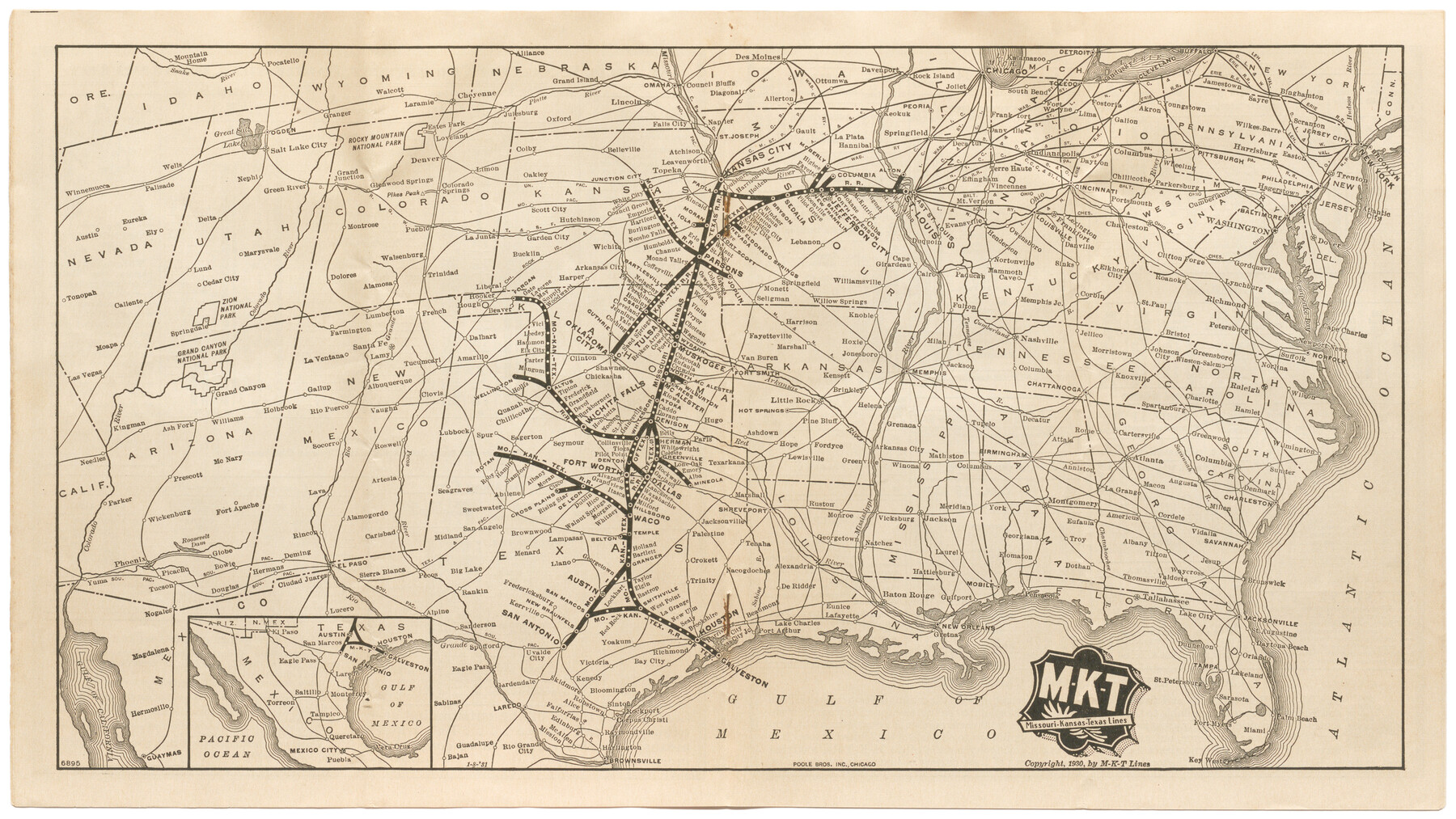
MKT - Missouri, Kansas, Texas Lines
-
Map/Doc
95811
-
Collection
Cobb Digital Map Collection
-
Object Dates
1930 (Creation Date)
-
Subjects
Railroads United States
-
Height x Width
9.1 x 16.1 inches
23.1 x 40.9 cm
-
Medium
digital image
-
Comments
Courtesy of John & Diana Cobb.
To view full booklet in which this map was contained, click "Download PDF" link above.
Related maps
MKT (Missouri Kansas Texas) Katy Railroad Time Tables

Print $54.00
- Digital $50.00
MKT (Missouri Kansas Texas) Katy Railroad Time Tables
1946
Size 9.3 x 16.4 inches
Map/Doc 93981
Part of: Cobb Digital Map Collection
Revised map of the State of Texas

Print $20.00
- Digital $50.00
Revised map of the State of Texas
1876
Size 19.6 x 19.7 inches
Map/Doc 95755
The M. K. and T., Missouri, Kansas & Texas Railway

Print $20.00
- Digital $50.00
The M. K. and T., Missouri, Kansas & Texas Railway
1890
Size 25.0 x 27.9 inches
Map/Doc 95807
Map of the Southern and South-western States engraved to accompany Appletons' hand book of American travel

Print $20.00
- Digital $50.00
Map of the Southern and South-western States engraved to accompany Appletons' hand book of American travel
1849
Size 13.0 x 17.8 inches
Map/Doc 95902
Map of the Texas & Pacific Railway and connections

Print $20.00
- Digital $50.00
Map of the Texas & Pacific Railway and connections
1899
Size 17.9 x 36.6 inches
Map/Doc 95765
[Map of North Carolina and South Carolina]
![96621, [Map of North Carolina and South Carolina], Cobb Digital Map Collection](https://historictexasmaps.com/wmedia_w700/maps/96621.tif.jpg)
Print $20.00
- Digital $50.00
[Map of North Carolina and South Carolina]
1869
Size 8.9 x 9.2 inches
Map/Doc 96621
The Northern Pacific Railroad and Connections

Print $20.00
- Digital $50.00
The Northern Pacific Railroad and Connections
1892
Size 23.1 x 35.7 inches
Map/Doc 96583
Oklahoma and Indian Territory Along the Frisco

Oklahoma and Indian Territory Along the Frisco
1905
Map/Doc 96771
Competing Transportation Lines between Boston, New York, Philadelphia, Baltimore, and the South Atlantic and Gulf States

Print $20.00
- Digital $50.00
Competing Transportation Lines between Boston, New York, Philadelphia, Baltimore, and the South Atlantic and Gulf States
1881
Size 15.1 x 17.8 inches
Map/Doc 95907

![[San Benito Promotional Booklet]](https://historictexasmaps.com/wmedia_w700/pdf_converted_jpg/qi_pdf_thumbnail_64211.jpg)
The Newest Land Of Promise - The Pecos Valley in Texas

Print $20.00
- Digital $50.00
The Newest Land Of Promise - The Pecos Valley in Texas
1900
Size 17.8 x 22.8 inches
Map/Doc 97037
Corpus Christi, Where Texas Meets the Sea

Corpus Christi, Where Texas Meets the Sea
1927
Size 9.6 x 4.3 inches
Map/Doc 97064
You may also like
[Unknown Connecting Line]
![92040, [Unknown Connecting Line], Twichell Survey Records](https://historictexasmaps.com/wmedia_w700/maps/92040-1.tif.jpg)
Print $20.00
- Digital $50.00
[Unknown Connecting Line]
Size 28.1 x 23.0 inches
Map/Doc 92040
[Surveys in Austin's Colony by Horatio Chriesman along Mill and Cummins Creeks]
![68, [Surveys in Austin's Colony by Horatio Chriesman along Mill and Cummins Creeks], General Map Collection](https://historictexasmaps.com/wmedia_w700/maps/68.tif.jpg)
Print $20.00
- Digital $50.00
[Surveys in Austin's Colony by Horatio Chriesman along Mill and Cummins Creeks]
1830
Size 30.7 x 25.7 inches
Map/Doc 68
Old Miscellaneous File 12

Print $14.00
- Digital $50.00
Old Miscellaneous File 12
1899
Size 14.2 x 8.6 inches
Map/Doc 75439
Tyler County Working Sketch 8

Print $20.00
- Digital $50.00
Tyler County Working Sketch 8
1937
Size 31.0 x 34.9 inches
Map/Doc 69478
Cooke County Sketch File 19

Print $8.00
- Digital $50.00
Cooke County Sketch File 19
1861
Size 7.9 x 6.1 inches
Map/Doc 19260
Bee County Working Sketch 16

Print $20.00
- Digital $50.00
Bee County Working Sketch 16
1974
Size 18.0 x 19.6 inches
Map/Doc 67266
Laredo Route. Mexican National Railroad - the Shortest Line to Mexico

Print $20.00
- Digital $50.00
Laredo Route. Mexican National Railroad - the Shortest Line to Mexico
1905
Size 11.0 x 8.5 inches
Map/Doc 96589
Val Verde County Sketch File Z8

Print $20.00
- Digital $50.00
Val Verde County Sketch File Z8
1884
Size 25.2 x 19.9 inches
Map/Doc 12553
Calhoun County Sketch File 18

Print $61.00
- Digital $50.00
Calhoun County Sketch File 18
1990
Size 11.2 x 8.7 inches
Map/Doc 35986
Nueces County Rolled Sketch 52

Print $20.00
- Digital $50.00
Nueces County Rolled Sketch 52
1938
Size 31.3 x 31.7 inches
Map/Doc 9606
Houston County

Print $40.00
- Digital $50.00
Houston County
1944
Size 49.3 x 51.0 inches
Map/Doc 76037
Bailey County

Print $20.00
- Digital $50.00
Bailey County
1913
Size 28.8 x 22.3 inches
Map/Doc 66707