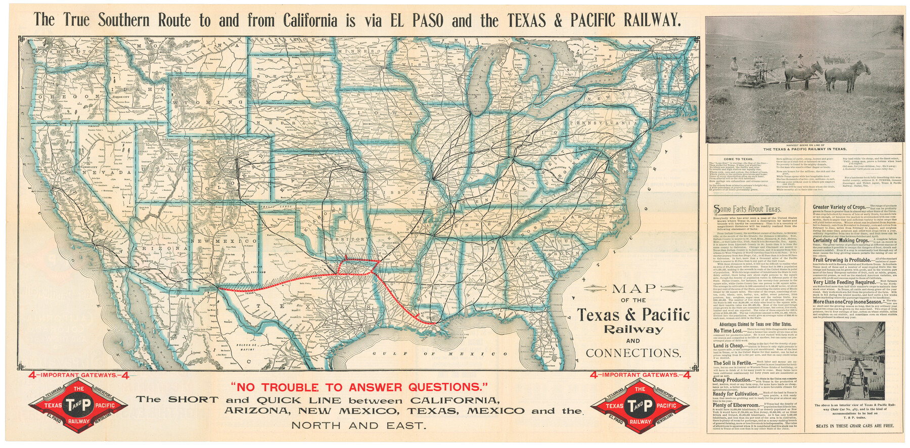
Map of the Texas & Pacific Railway and connections
The Short Line from Texas, Mexico, and California to St. Louis, Memphis and all points North & East / The Direct Through Line from California, Colorado, and the West to Shreveport, New Orleans, Memphis and all points in the Southeast
-
Map/Doc
95766
-
Collection
Cobb Digital Map Collection
-
Object Dates
4/1899 (Creation Date)
-
People and Organizations
Woodward & Tiernan Printing Co. (Printer)
-
Subjects
Railroads Texas and Pacific Railroad United States
-
Height x Width
17.8 x 36.3 inches
45.2 x 92.2 cm
-
Medium
digital image
-
Comments
Courtesy of John & Diana Cobb.
To view timetables printed on verso, click "Download PDF" link above.
Part of: Cobb Digital Map Collection
San Benito, Texas on the Frisco in the Lower Rio Grande Valley

San Benito, Texas on the Frisco in the Lower Rio Grande Valley
1911
Map/Doc 96727

The Rand McNally New Commercial Atlas Map of Texas

Print $20.00
- Digital $50.00
The Rand McNally New Commercial Atlas Map of Texas
1914
Size 28.6 x 40.2 inches
Map/Doc 95849
Scenes Around Carrizo Springs, Texas the Hub of the Winter Garden District

Print $20.00
- Digital $50.00
Scenes Around Carrizo Springs, Texas the Hub of the Winter Garden District
1920
Size 8.8 x 15.5 inches
Map/Doc 96767
Correct Map of Texas

Print $20.00
- Digital $50.00
Correct Map of Texas
1904
Size 17.9 x 22.3 inches
Map/Doc 95768

The Industrial Evolution of the agricultural wonderland of the southwest

Print $20.00
- Digital $50.00
The Industrial Evolution of the agricultural wonderland of the southwest
1927
Size 13.7 x 16.7 inches
Map/Doc 96760
Rand McNally New Official Railroad Map of the United States and Southern Canada

Print $20.00
- Digital $50.00
Rand McNally New Official Railroad Map of the United States and Southern Canada
1910
Size 29.5 x 40.0 inches
Map/Doc 95860
Map of the Iron Mountain Route - St. Louis, Iron Mountain and Southern Railway and connections, the great fast mail line to St. Louis, Arkansas and Texas

Print $20.00
- Digital $50.00
Map of the Iron Mountain Route - St. Louis, Iron Mountain and Southern Railway and connections, the great fast mail line to St. Louis, Arkansas and Texas
1882
Size 14.9 x 24.1 inches
Map/Doc 95787

The M. K. and T., Missouri, Kansas & Texas Railway

Print $20.00
- Digital $50.00
The M. K. and T., Missouri, Kansas & Texas Railway
1890
Size 25.0 x 27.9 inches
Map/Doc 95807
Laredo Route. Mexican National Railroad - the Shortest Line to Mexico

Print $20.00
- Digital $50.00
Laredo Route. Mexican National Railroad - the Shortest Line to Mexico
1905
Size 11.0 x 8.5 inches
Map/Doc 96589
You may also like
Harris County Working Sketch 87

Print $20.00
- Digital $50.00
Harris County Working Sketch 87
1972
Size 34.1 x 31.0 inches
Map/Doc 65979
Flight Mission No. DQO-12K, Frame 35, Galveston County

Print $20.00
- Digital $50.00
Flight Mission No. DQO-12K, Frame 35, Galveston County
1952
Size 18.7 x 22.4 inches
Map/Doc 85226
Lampasas County Boundary File 15a

Print $33.00
- Digital $50.00
Lampasas County Boundary File 15a
Size 13.3 x 8.2 inches
Map/Doc 56210
Copy of Surveyor's Field Book, Morris Browning - In Blocks 7, 5 & 4, I&GNRRCo., Hutchinson and Carson Counties, Texas

Print $2.00
- Digital $50.00
Copy of Surveyor's Field Book, Morris Browning - In Blocks 7, 5 & 4, I&GNRRCo., Hutchinson and Carson Counties, Texas
1888
Size 7.0 x 8.9 inches
Map/Doc 62277
Collin County Boundary File 2

Print $6.00
- Digital $50.00
Collin County Boundary File 2
Size 12.9 x 8.0 inches
Map/Doc 51682
Milam County Working Sketch 17

Print $40.00
- Digital $50.00
Milam County Working Sketch 17
1972
Size 54.7 x 32.2 inches
Map/Doc 89031
Schleicher County Sketch File 39

Print $9.00
- Digital $50.00
Schleicher County Sketch File 39
1958
Size 14.8 x 9.4 inches
Map/Doc 36538
[Sketch Showing G. H. & H. R.R. Co. Block 3B and A. B. & M. Block M16, Hutchinson County, Texas]
![75813, [Sketch Showing G. H. & H. R.R. Co. Block 3B and A. B. & M. Block M16, Hutchinson County, Texas], Maddox Collection](https://historictexasmaps.com/wmedia_w700/maps/75813.tif.jpg)
Print $20.00
- Digital $50.00
[Sketch Showing G. H. & H. R.R. Co. Block 3B and A. B. & M. Block M16, Hutchinson County, Texas]
Size 20.7 x 21.5 inches
Map/Doc 75813
Wilbarger County Sketch File 9

Print $4.00
- Digital $50.00
Wilbarger County Sketch File 9
1885
Size 12.7 x 8.2 inches
Map/Doc 40181
Sulphur River and Cut Hand Creek, Hardison Lake Sheet

Print $20.00
- Digital $50.00
Sulphur River and Cut Hand Creek, Hardison Lake Sheet
1919
Size 22.5 x 24.2 inches
Map/Doc 65177
Val Verde County Rolled Sketch 72A

Print $20.00
- Digital $50.00
Val Verde County Rolled Sketch 72A
Size 15.5 x 37.8 inches
Map/Doc 8135
DeWitt County Working Sketch 12

Print $20.00
- Digital $50.00
DeWitt County Working Sketch 12
1981
Size 17.0 x 12.5 inches
Map/Doc 68602