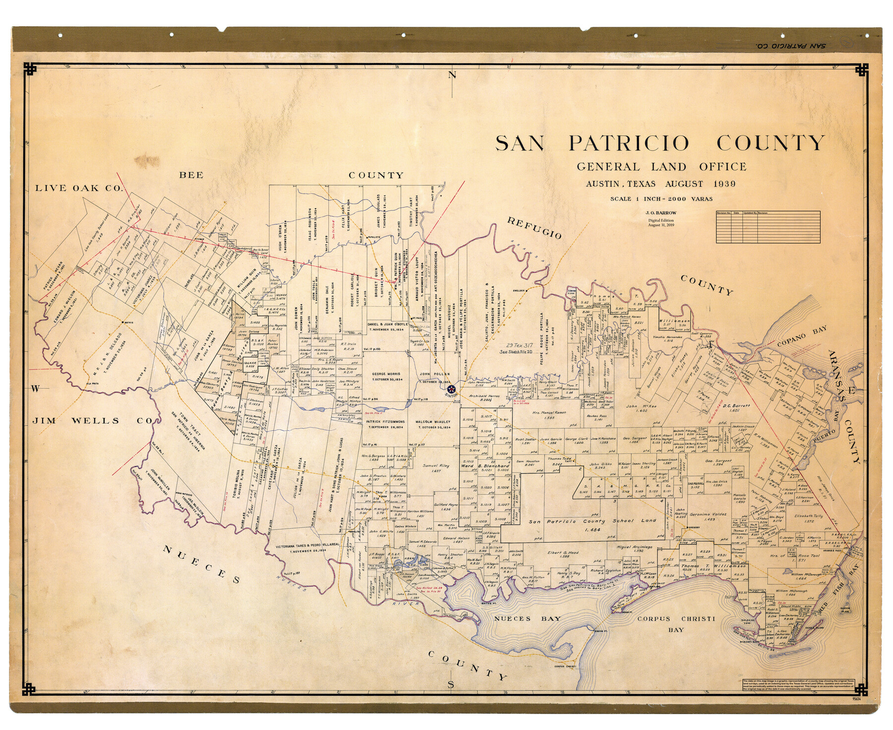
San Patricio County
General Land Office Official County Map
-
Map/Doc
95634
-
Collection
General Map Collection
-
Object Dates
2019/8/31 (Revision Date)
1939 (Creation Date)
-
People and Organizations
Cheyenne Betancourt (Draftsman)
J.O. Barrow (Draftsman)
-
Counties
San Patricio
-
Subjects
County OCM
-
Height x Width
40.3 x 49.3 inches
102.4 x 125.2 cm
-
Medium
digital image
-
Scale
1" = 2000 varas
Part of: General Map Collection
Culberson County Working Sketch 25

Print $40.00
- Digital $50.00
Culberson County Working Sketch 25
1951
Size 30.5 x 52.9 inches
Map/Doc 68478
Upton County Sketch File 4

Print $40.00
- Digital $50.00
Upton County Sketch File 4
1886
Size 19.5 x 9.0 inches
Map/Doc 12510
Loving County Working Sketch 12

Print $40.00
- Digital $50.00
Loving County Working Sketch 12
1957
Size 48.1 x 37.1 inches
Map/Doc 70645
Tyler County Sketch File 21

Print $4.00
- Digital $50.00
Tyler County Sketch File 21
1906
Size 10.9 x 9.1 inches
Map/Doc 38677
Hutchinson County Rolled Sketch 44-5

Print $20.00
- Digital $50.00
Hutchinson County Rolled Sketch 44-5
2002
Size 24.0 x 36.0 inches
Map/Doc 77541
Flight Mission No. CLL-1N, Frame 80, Willacy County

Print $20.00
- Digital $50.00
Flight Mission No. CLL-1N, Frame 80, Willacy County
1954
Size 18.4 x 22.1 inches
Map/Doc 87026
Dimmit County Working Sketch 57

Print $20.00
- Digital $50.00
Dimmit County Working Sketch 57
2008
Size 26.1 x 31.7 inches
Map/Doc 88847
Shelby County Working Sketch 20

Print $20.00
- Digital $50.00
Shelby County Working Sketch 20
1970
Size 28.0 x 22.8 inches
Map/Doc 63873
Val Verde County Working Sketch 34

Print $20.00
- Digital $50.00
Val Verde County Working Sketch 34
1940
Size 33.7 x 27.9 inches
Map/Doc 72169
Flight Mission No. DQN-5K, Frame 79, Calhoun County

Print $20.00
- Digital $50.00
Flight Mission No. DQN-5K, Frame 79, Calhoun County
1953
Size 18.5 x 22.2 inches
Map/Doc 84412
Kerr County Working Sketch 32

Print $20.00
- Digital $50.00
Kerr County Working Sketch 32
1975
Size 33.8 x 25.3 inches
Map/Doc 70063
Frio County Working Sketch 17

Print $20.00
- Digital $50.00
Frio County Working Sketch 17
1980
Size 14.4 x 16.8 inches
Map/Doc 69291
You may also like
Cochran County, Texas

Print $20.00
- Digital $50.00
Cochran County, Texas
Size 29.8 x 37.5 inches
Map/Doc 92492
Newton County Working Sketch 7

Print $20.00
- Digital $50.00
Newton County Working Sketch 7
1936
Size 32.3 x 37.0 inches
Map/Doc 71253
Briscoe County Rolled Sketch WL

Print $20.00
- Digital $50.00
Briscoe County Rolled Sketch WL
1936
Size 18.6 x 43.0 inches
Map/Doc 5335
Wise County Sketch File 50

Print $20.00
- Digital $50.00
Wise County Sketch File 50
1895
Size 23.7 x 29.9 inches
Map/Doc 12703
Main Line Routes of the Santa Fe Lines

Main Line Routes of the Santa Fe Lines
Size 12.1 x 18.1 inches
Map/Doc 94157
Palo Pinto County Rolled Sketch 8

Print $40.00
- Digital $50.00
Palo Pinto County Rolled Sketch 8
Size 116.4 x 54.6 inches
Map/Doc 9674

Controlled Mosaic by Jack Amman Photogrammetric Engineers, Inc - Sheet 23

Print $20.00
- Digital $50.00
Controlled Mosaic by Jack Amman Photogrammetric Engineers, Inc - Sheet 23
1954
Size 20.0 x 24.0 inches
Map/Doc 83474
Engineer's Office, Department of the Gulf Map No. 59, Texas prepared by order of Maj. Gen. N. P. Banks under direction of Capt. P. C. Hains, U. S. Engr. & Chief Engr., Dept. of the Gulf

Print $20.00
- Digital $50.00
Engineer's Office, Department of the Gulf Map No. 59, Texas prepared by order of Maj. Gen. N. P. Banks under direction of Capt. P. C. Hains, U. S. Engr. & Chief Engr., Dept. of the Gulf
1865
Size 18.3 x 27.5 inches
Map/Doc 72719
Hemphill County Working Sketch 33

Print $20.00
- Digital $50.00
Hemphill County Working Sketch 33
1976
Size 39.6 x 32.3 inches
Map/Doc 66128
Montgomery County

Print $20.00
- Digital $50.00
Montgomery County
1901
Size 42.2 x 47.4 inches
Map/Doc 66939
Bexar County Working Sketch 20

Print $20.00
- Digital $50.00
Bexar County Working Sketch 20
1982
Size 42.4 x 43.6 inches
Map/Doc 67336