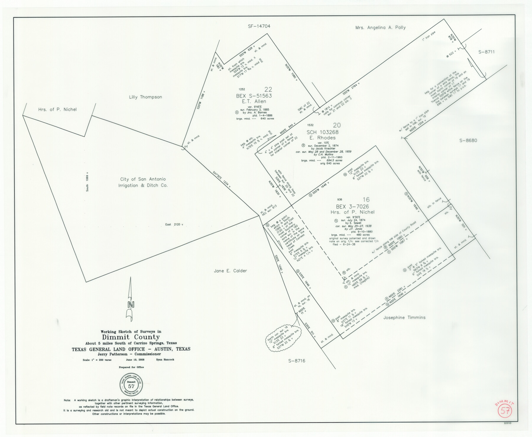
Dimmit County Working Sketch 57
- 
                          Map/Doc88847
- 
                            CollectionGeneral Map Collection
- 
                            Object Dates6/19/2008 (Creation Date)
- 
                            People and OrganizationsJerry E. Patterson (GLO Commissioner)Ryan Hancock (Draftsman)
- 
                            CountiesDimmit
- 
                            SubjectsSurveying Working Sketch
- 
                            Height x Width26.1 x 31.7 inches66.3 x 80.5 cm
- 
                            Scale1" = 200 varas
Part of: General Map Collection
            Wilbarger County Working Sketch 22


                                            Print $20.00                    
                                             -                         Digital $50.00                                    
                Wilbarger County Working Sketch 22
1983
Size 39.8 x 33.6 inches
                                Map/Doc 72560
            
            Henderson County Sketch File 1


                                            Print $8.00                    
                                             -                         Digital $50.00                                    
                Henderson County Sketch File 1
Size 12.8 x 8.3 inches
                                Map/Doc 26318
            
            Brazoria County Working Sketch 38


                                            Print $40.00                    
                                             -                         Digital $50.00                                    
                Brazoria County Working Sketch 38
1981
Size 53.2 x 37.7 inches
                                Map/Doc 67523
            
            Zapata County Sketch File 16


                                            Print $6.00                    
                                             -                         Digital $50.00                                    
                Zapata County Sketch File 16
Size 14.5 x 8.8 inches
                                Map/Doc 40957
            
            Clay County Boundary File 12


                                            Print $8.00                    
                                             -                         Digital $50.00                                    
                Clay County Boundary File 12
Size 14.3 x 8.8 inches
                                Map/Doc 51406
            
            [Coastal Chart of Galveston Island, Bolivar Peninsula and Galveston Bay]
            
                                    ![61804, [Coastal Chart of Galveston Island, Bolivar Peninsula and Galveston Bay], General Map Collection](https://historictexasmaps.com/wmedia_w700/maps/61804.tif.jpg) 


    ![61804, [Coastal Chart of Galveston Island, Bolivar Peninsula and Galveston Bay], General Map Collection](https://historictexasmaps.com/wmedia_w700/maps/61804.tif.jpg) 
                                
            
                                            Print $20.00                    
                                             -                         Digital $50.00                                    
                [Coastal Chart of Galveston Island, Bolivar Peninsula and Galveston Bay]
Size 24.0 x 18.1 inches
                                Map/Doc 61804
            
            Flight Mission No. DCL-6C, Frame 180, Kenedy County


                                            Print $20.00                    
                                             -                         Digital $50.00                                    
                Flight Mission No. DCL-6C, Frame 180, Kenedy County
1943
Size 18.5 x 22.4 inches
                                Map/Doc 85992
            
            Flight Mission No. DIX-7P, Frame 83, Aransas County


                                            Print $20.00                    
                                             -                         Digital $50.00                                    
                Flight Mission No. DIX-7P, Frame 83, Aransas County
1956
Size 18.8 x 22.5 inches
                                Map/Doc 83877
            
            Irion County Rolled Sketch 9


                                            Print $20.00                    
                                             -                         Digital $50.00                                    
                Irion County Rolled Sketch 9
1940
Size 31.9 x 30.6 inches
                                Map/Doc 6321
            
            Austin County Working Sketch 2


                                            Print $20.00                    
                                             -                         Digital $50.00                                    
                Austin County Working Sketch 2
1944
Size 23.3 x 27.0 inches
                                Map/Doc 67243
            
            Cass County Working Sketch 28


                                            Print $20.00                    
                                             -                         Digital $50.00                                    
                Cass County Working Sketch 28
1979
Size 16.0 x 16.8 inches
                                Map/Doc 67931
            
            Wilbarger County Working Sketch 11


                                            Print $40.00                    
                                             -                         Digital $50.00                                    
                Wilbarger County Working Sketch 11
1952
Size 27.7 x 51.7 inches
                                Map/Doc 72549
            You may also like
            Llano County Boundary File 3


                                            Print $42.00                    
                                             -                         Digital $50.00                                    
                Llano County Boundary File 3
Size 14.1 x 8.7 inches
                                Map/Doc 56449
            
            Hutchinson County Sketch File 18


                                            Print $28.00                    
                                             -                         Digital $50.00                                    
                Hutchinson County Sketch File 18
1909
Size 6.7 x 8.3 inches
                                Map/Doc 27220
            
            Map of Leon County


                                            Print $20.00                    
                                             -                         Digital $50.00                                    
                Map of Leon County
1867
Size 25.5 x 23.1 inches
                                Map/Doc 3809
            
            Buffalo Bayou and the Houston Ship Channel 1820-1926


            Buffalo Bayou and the Houston Ship Channel 1820-1926
1926
Size 6.2 x 9.1 inches
                                Map/Doc 97071
            
            Sketch T [showing Capitol Reserve]
            
                                    ![89631, Sketch T [showing Capitol Reserve], Twichell Survey Records](https://historictexasmaps.com/wmedia_w700/maps/89631-1.tif.jpg) 


    ![89631, Sketch T [showing Capitol Reserve], Twichell Survey Records](https://historictexasmaps.com/wmedia_w700/maps/89631-1.tif.jpg) 
                                
            
                                            Print $40.00                    
                                             -                         Digital $50.00                                    
                Sketch T [showing Capitol Reserve]
1903
Size 22.0 x 48.9 inches
                                Map/Doc 89631
            
            Sutton County Working Sketch 6


                                            Print $20.00                    
                                             -                         Digital $50.00                                    
                Sutton County Working Sketch 6
1972
Size 39.3 x 37.4 inches
                                Map/Doc 62349
            
            Collingsworth County Rolled Sketch 2A


                                            Print $20.00                    
                                             -                         Digital $50.00                                    
                Collingsworth County Rolled Sketch 2A
1888
Size 15.3 x 45.8 inches
                                Map/Doc 8638
            
            Blanco County Working Sketch 33


                                            Print $40.00                    
                                             -                         Digital $50.00                                    
                Blanco County Working Sketch 33
1978
Size 41.0 x 57.5 inches
                                Map/Doc 67393
            
            Wise County Sketch File 7


                                            Print $4.00                    
                                             -                         Digital $50.00                                    
                Wise County Sketch File 7
1857
Size 8.1 x 14.0 inches
                                Map/Doc 40535
            
            Archer County Working Sketch 5


                                            Print $20.00                    
                                             -                         Digital $50.00                                    
                Archer County Working Sketch 5
1919
Size 14.7 x 23.4 inches
                                Map/Doc 67145
            
            Uvalde County Sketch File 21


                                            Print $8.00                    
                                             -                         Digital $50.00                                    
                Uvalde County Sketch File 21
1882
Size 14.2 x 8.8 inches
                                Map/Doc 39004
             
                        