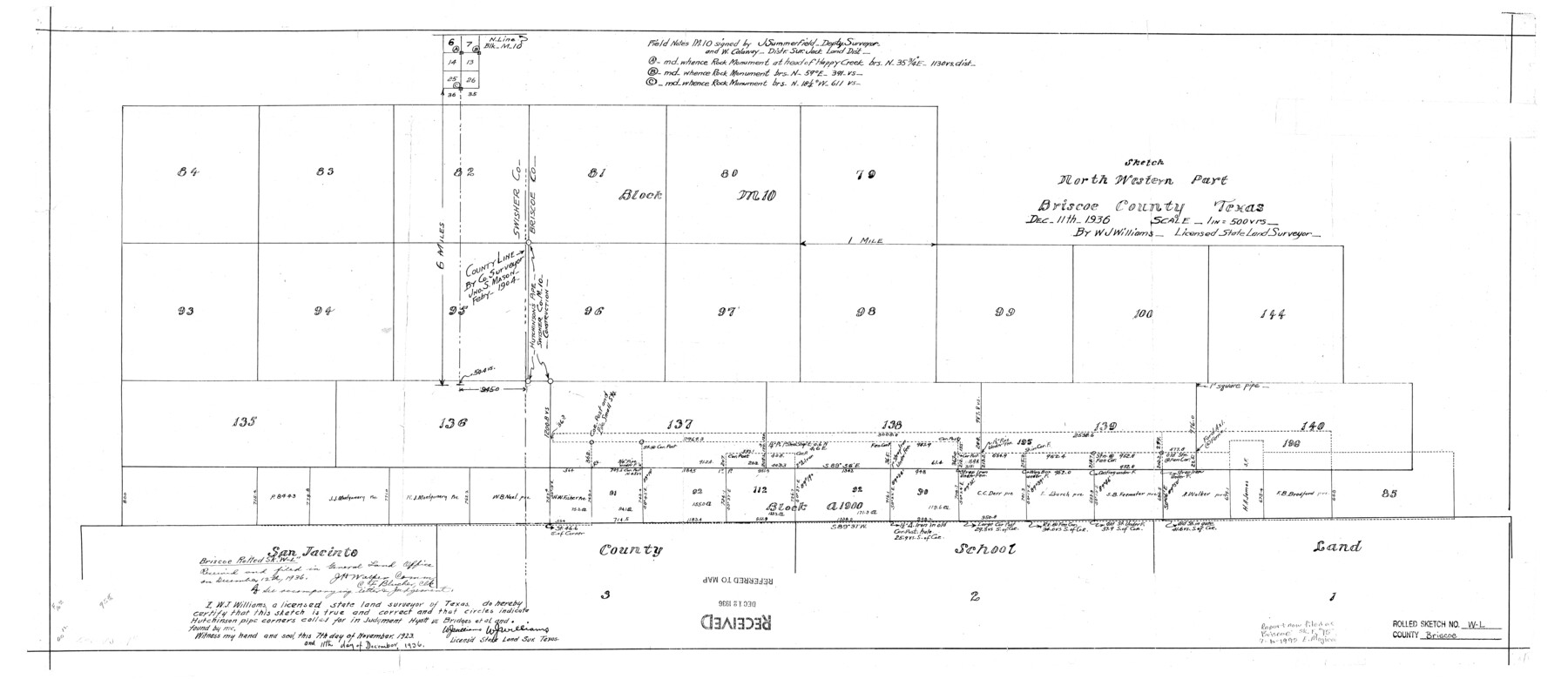
Briscoe County Rolled Sketch WL
Sketch north western part [of] Briscoe County, Texas
-
Map/Doc
5335
-
Collection
General Map Collection
-
Object Dates
1936/12/11 (Creation Date)
1936/12/12 (File Date)
-
People and Organizations
W.J. Williams (Surveyor/Engineer)
-
Counties
Briscoe Swisher
-
Subjects
Surveying Rolled Sketch
-
Height x Width
18.6 x 43.0 inches
47.2 x 109.2 cm
-
Medium
blueprint/diazo
-
Scale
1" = 500 varas
-
Comments
See Briscoe County Sketch File 15 (16522) for surveyor’s report, correspondence, and judgement.
Related maps
Briscoe County Sketch File 15

Print $26.00
- Digital $50.00
Briscoe County Sketch File 15
Size 11.2 x 8.9 inches
Map/Doc 16522
Part of: General Map Collection
A Traveler's Map of Spain and Portugal

A Traveler's Map of Spain and Portugal
Size 20.4 x 31.2 inches
Map/Doc 95929
Eastland County Sketch File 19

Print $2.00
- Digital $50.00
Eastland County Sketch File 19
1983
Size 14.3 x 9.0 inches
Map/Doc 21608
Flight Mission No. CUG-3P, Frame 139, Kleberg County

Print $20.00
- Digital $50.00
Flight Mission No. CUG-3P, Frame 139, Kleberg County
1956
Size 18.6 x 22.4 inches
Map/Doc 86274
Midland County Working Sketch 26

Print $20.00
- Digital $50.00
Midland County Working Sketch 26
1962
Size 24.8 x 28.6 inches
Map/Doc 71007
Flight Mission No. CGI-3N, Frame 96, Cameron County

Print $20.00
- Digital $50.00
Flight Mission No. CGI-3N, Frame 96, Cameron County
1954
Size 18.5 x 22.1 inches
Map/Doc 84576
Comanche County Working Sketch 2

Print $20.00
- Digital $50.00
Comanche County Working Sketch 2
1918
Size 15.0 x 21.5 inches
Map/Doc 68136
[Untitled Map of Baja California & West Coast of Mexico]

Print $20.00
- Digital $50.00
[Untitled Map of Baja California & West Coast of Mexico]
1541
Size 11.1 x 16.7 inches
Map/Doc 97353
Kerr County Working Sketch 15

Print $20.00
- Digital $50.00
Kerr County Working Sketch 15
1953
Size 36.2 x 38.6 inches
Map/Doc 70046
Wharton County Sketch File 10

Print $4.00
- Digital $50.00
Wharton County Sketch File 10
1882
Size 10.9 x 8.5 inches
Map/Doc 39931
[Surveys along the Leon River and Plum Creek]
![255, [Surveys along the Leon River and Plum Creek], General Map Collection](https://historictexasmaps.com/wmedia_w700/maps/255.tif.jpg)
Print $2.00
- Digital $50.00
[Surveys along the Leon River and Plum Creek]
1846
Size 11.7 x 7.6 inches
Map/Doc 255
Flight Mission No. CRC-4R, Frame 104, Chambers County

Print $20.00
- Digital $50.00
Flight Mission No. CRC-4R, Frame 104, Chambers County
1956
Size 18.6 x 22.4 inches
Map/Doc 84901

You may also like
Ector County Working Sketch 26

Print $20.00
- Digital $50.00
Ector County Working Sketch 26
1961
Size 30.8 x 43.6 inches
Map/Doc 68869
Cochran County
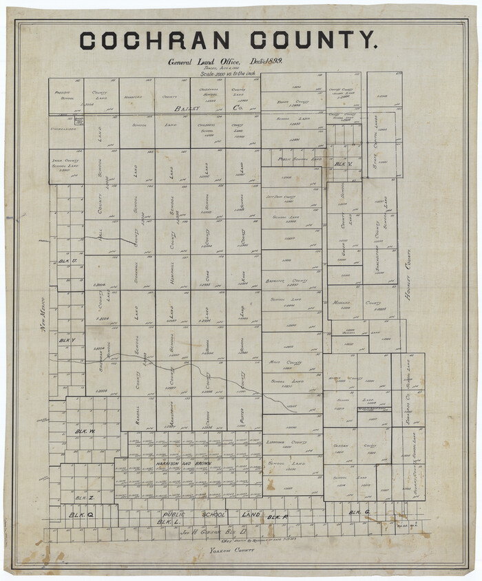
Print $20.00
- Digital $50.00
Cochran County
1899
Size 41.1 x 34.1 inches
Map/Doc 66755
Hudspeth County Rolled Sketch 69

Print $20.00
- Digital $50.00
Hudspeth County Rolled Sketch 69
1973
Size 12.3 x 19.8 inches
Map/Doc 6264
[Leagues 157-160]
![90298, [Leagues 157-160], Twichell Survey Records](https://historictexasmaps.com/wmedia_w700/maps/90298-1.tif.jpg)
Print $20.00
- Digital $50.00
[Leagues 157-160]
Size 8.2 x 22.6 inches
Map/Doc 90298
Upton County Sketch File 5

Print $40.00
- Digital $50.00
Upton County Sketch File 5
Size 8.7 x 24.4 inches
Map/Doc 38813
Surveys made on the San Miguel. March 1847

Print $2.00
- Digital $50.00
Surveys made on the San Miguel. March 1847
1847
Size 10.4 x 8.4 inches
Map/Doc 223
San Patricio County Working Sketch 22

Print $20.00
- Digital $50.00
San Patricio County Working Sketch 22
1981
Size 30.0 x 24.1 inches
Map/Doc 63784
Matagorda County Sketch File 12

Print $2.00
- Digital $50.00
Matagorda County Sketch File 12
Size 8.4 x 7.0 inches
Map/Doc 30771
[Leagues 218- 236]
![91454, [Leagues 218- 236], Twichell Survey Records](https://historictexasmaps.com/wmedia_w700/maps/91454-1.tif.jpg)
Print $2.00
- Digital $50.00
[Leagues 218- 236]
Size 7.0 x 11.6 inches
Map/Doc 91454
Willacy County Sketch File 1a

Print $272.00
- Digital $50.00
Willacy County Sketch File 1a
1977
Size 8.3 x 3.7 inches
Map/Doc 40239
[Rosebud Station Map - Tracks and Structures - Lands, San Antonio and Aransas Pass Railway Co.]
![62566, [Rosebud Station Map - Tracks and Structures - Lands, San Antonio and Aransas Pass Railway Co.], General Map Collection](https://historictexasmaps.com/wmedia_w700/maps/62566.tif.jpg)
Print $4.00
- Digital $50.00
[Rosebud Station Map - Tracks and Structures - Lands, San Antonio and Aransas Pass Railway Co.]
1919
Size 11.7 x 18.6 inches
Map/Doc 62566
Flight Mission No. BRE-5P, Frame 200, Nueces County

Print $20.00
- Digital $50.00
Flight Mission No. BRE-5P, Frame 200, Nueces County
1956
Size 18.6 x 22.7 inches
Map/Doc 86840