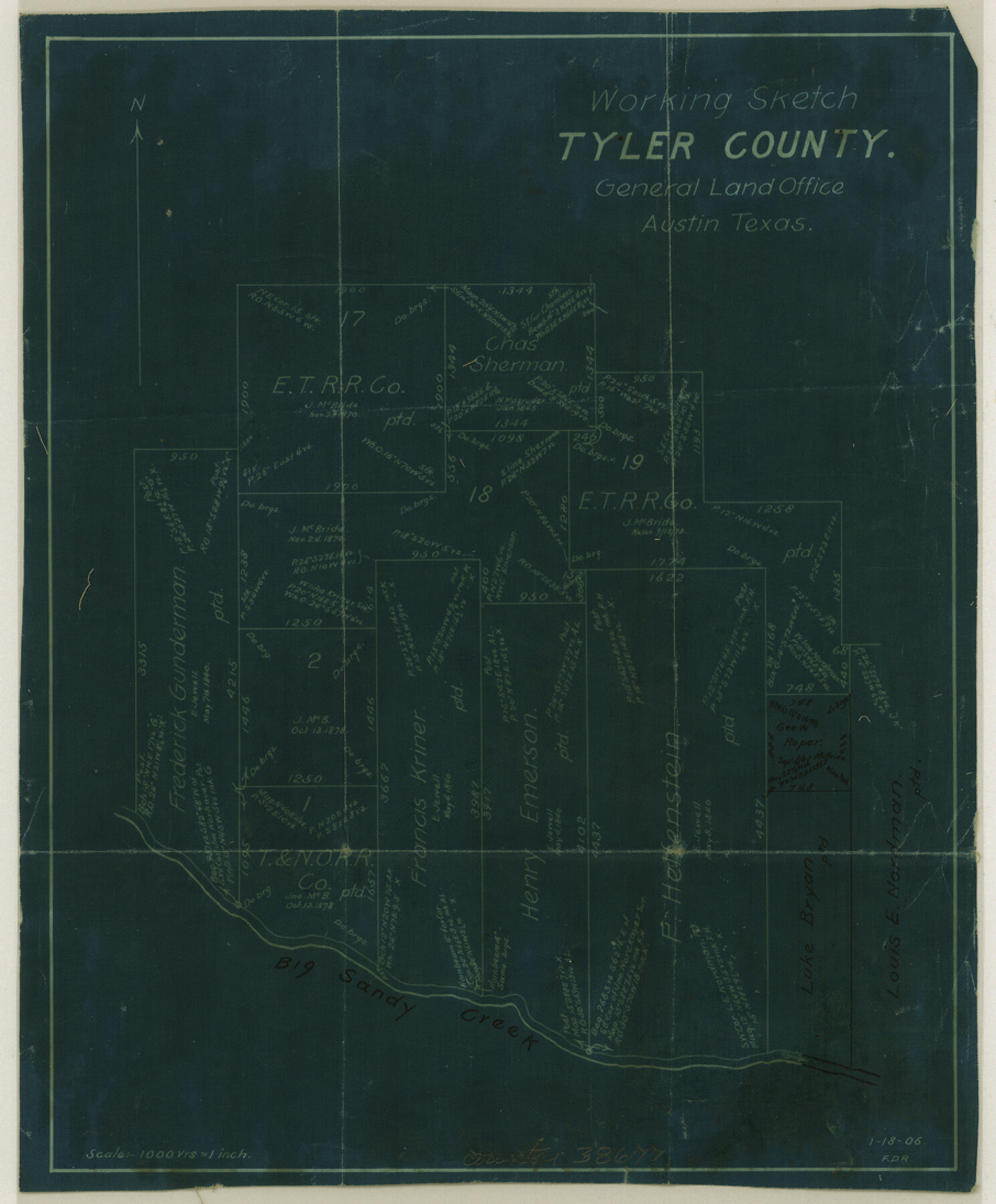
Tyler County Sketch File 21
[Working sketch of surveys on the north side of Big Sandy Creek in the southwest corner of the county]
-
Map/Doc
38677
-
Collection
General Map Collection
-
Object Dates
1/18/1906 (Creation Date)
-
People and Organizations
F.D. Russell (Draftsman)
-
Counties
Tyler Hardin
-
Subjects
Surveying Sketch File
-
Height x Width
10.9 x 9.1 inches
27.7 x 23.1 cm
-
Medium
blueprint/diazo
-
Scale
1" = 1000 varas
-
Features
Big Sandy Creek
Part of: General Map Collection
Morris County Rolled Sketch 2A

Print $20.00
- Digital $50.00
Morris County Rolled Sketch 2A
Size 24.0 x 18.7 inches
Map/Doc 10225
Henderson County Sketch File 16

Print $40.00
- Digital $50.00
Henderson County Sketch File 16
1935
Size 14.9 x 16.3 inches
Map/Doc 26359
Brazoria County NRC Article 33.136 Sketch 27

Print $24.00
Brazoria County NRC Article 33.136 Sketch 27
2025
Map/Doc 97472
Cherokee County Sketch File 30

Print $17.00
- Digital $50.00
Cherokee County Sketch File 30
1934
Size 10.3 x 9.4 inches
Map/Doc 18176
Liberty County Sketch File 37a

Print $6.00
- Digital $50.00
Liberty County Sketch File 37a
1895
Size 15.1 x 11.5 inches
Map/Doc 29981
Frio County Working Sketch 5

Print $20.00
- Digital $50.00
Frio County Working Sketch 5
1936
Size 33.9 x 23.0 inches
Map/Doc 69279
Flight Mission No. DCL-6C, Frame 112, Kenedy County

Print $20.00
- Digital $50.00
Flight Mission No. DCL-6C, Frame 112, Kenedy County
1943
Size 15.4 x 15.5 inches
Map/Doc 85942

Flight Mission No. CGN-3P, Frame 24, San Patricio County

Print $20.00
- Digital $50.00
Flight Mission No. CGN-3P, Frame 24, San Patricio County
1956
Size 18.5 x 22.3 inches
Map/Doc 86982
Map showing the line of march of the Centre Division, Army of Mexico, under the command of Brigr. Genl. John E. Wool, from San Antonio de Bexar, Texas to Saltillo, Mexico

Print $20.00
- Digital $50.00
Map showing the line of march of the Centre Division, Army of Mexico, under the command of Brigr. Genl. John E. Wool, from San Antonio de Bexar, Texas to Saltillo, Mexico
1846
Size 24.5 x 19.5 inches
Map/Doc 94074
Map of Brazos County, Texas

Print $40.00
- Digital $50.00
Map of Brazos County, Texas
1926
Size 89.6 x 55.1 inches
Map/Doc 93648

You may also like
Jeff Davis County Rolled Sketch 45

Print $40.00
- Digital $50.00
Jeff Davis County Rolled Sketch 45
2005
Size 91.3 x 44.0 inches
Map/Doc 87207
Pecos County Working Sketch 141

Print $20.00
- Digital $50.00
Pecos County Working Sketch 141
1941
Size 31.8 x 42.5 inches
Map/Doc 9733
[B. S. & F. Block 9 and surrounding area]
![93070, [B. S. & F. Block 9 and surrounding area], Twichell Survey Records](https://historictexasmaps.com/wmedia_w700/maps/93070-1.tif.jpg)
Print $20.00
- Digital $50.00
[B. S. & F. Block 9 and surrounding area]
Size 18.3 x 26.1 inches
Map/Doc 93070
Current Miscellaneous File 21

Print $26.00
- Digital $50.00
Current Miscellaneous File 21
1952
Size 10.8 x 8.2 inches
Map/Doc 73865
Henderson County Working Sketch 35

Print $20.00
- Digital $50.00
Henderson County Working Sketch 35
1963
Size 19.3 x 38.1 inches
Map/Doc 66168
Culberson County Sketch File 38

Print $20.00
- Digital $50.00
Culberson County Sketch File 38
1964
Size 21.7 x 18.6 inches
Map/Doc 11274
Culberson County Sketch File 24

Print $34.00
- Digital $50.00
Culberson County Sketch File 24
1934
Size 11.2 x 9.0 inches
Map/Doc 20242
Dallas/Fort Worth Street Map & Visitor Guide

Dallas/Fort Worth Street Map & Visitor Guide
2000
Size 35.5 x 23.1 inches
Map/Doc 94296
Zavala County Boundary File 4

Print $42.00
- Digital $50.00
Zavala County Boundary File 4
Size 9.2 x 7.9 inches
Map/Doc 60271
Coleman County Sketch File 41

Print $32.00
- Digital $50.00
Coleman County Sketch File 41
Size 12.8 x 8.4 inches
Map/Doc 18748
Hamilton County Working Sketch 25

Print $20.00
- Digital $50.00
Hamilton County Working Sketch 25
1963
Size 29.5 x 26.6 inches
Map/Doc 63363
Montgomery County Sketch File 35

Print $8.00
- Digital $50.00
Montgomery County Sketch File 35
1953
Size 14.1 x 8.9 inches
Map/Doc 31908