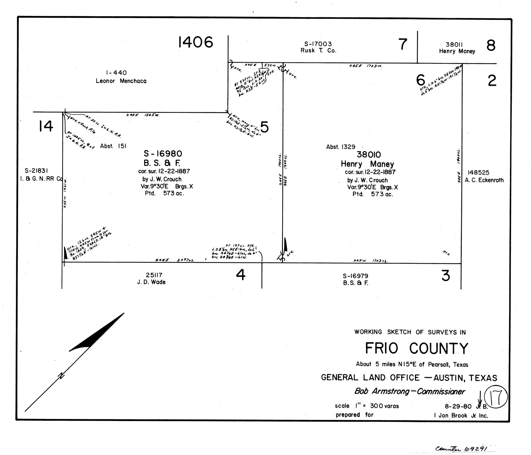
Frio County Working Sketch 17
-
Map/Doc
69291
-
Collection
General Map Collection
-
Object Dates
8/29/1980 (Creation Date)
-
People and Organizations
Jana Brod (Draftsman)
-
Counties
Frio
-
Subjects
Surveying Working Sketch
-
Height x Width
14.4 x 16.8 inches
36.6 x 42.7 cm
-
Scale
1" = 300 varas
Part of: General Map Collection
Terrell County Working Sketch 39

Print $20.00
- Digital $50.00
Terrell County Working Sketch 39
1951
Size 26.8 x 40.4 inches
Map/Doc 62132
Sutton County Working Sketch Graphic Index, Sheet 2 (Sketches 25 to Most Recent)

Print $40.00
- Digital $50.00
Sutton County Working Sketch Graphic Index, Sheet 2 (Sketches 25 to Most Recent)
1941
Size 41.2 x 55.2 inches
Map/Doc 76706
Refugio County Rolled Sketch 10

Print $42.00
- Digital $50.00
Refugio County Rolled Sketch 10
Size 49.9 x 39.1 inches
Map/Doc 9861
Marion County Working Sketch 26

Print $20.00
- Digital $50.00
Marion County Working Sketch 26
1970
Size 32.3 x 43.1 inches
Map/Doc 70802
Wise County Rolled Sketch 5

Print $20.00
- Digital $50.00
Wise County Rolled Sketch 5
Size 19.4 x 21.4 inches
Map/Doc 8271
Hudspeth County Sketch File 51

Print $4.00
- Digital $50.00
Hudspeth County Sketch File 51
1962
Size 14.4 x 9.1 inches
Map/Doc 27074
Flight Mission No. CGI-3G, Frame 16, Cameron County

Print $20.00
- Digital $50.00
Flight Mission No. CGI-3G, Frame 16, Cameron County
1950
Size 18.5 x 18.3 inches
Map/Doc 84664
Runnels County Rolled Sketch 32

Print $20.00
- Digital $50.00
Runnels County Rolled Sketch 32
Size 34.9 x 44.5 inches
Map/Doc 9868
Garza County Sketch File 25a

Print $14.00
- Digital $50.00
Garza County Sketch File 25a
Size 11.4 x 8.8 inches
Map/Doc 24088
Matagorda County Rolled Sketch 15

Print $20.00
- Digital $50.00
Matagorda County Rolled Sketch 15
Size 24.5 x 14.9 inches
Map/Doc 6682
Matagorda County Working Sketch 6

Print $20.00
- Digital $50.00
Matagorda County Working Sketch 6
1950
Size 24.2 x 41.5 inches
Map/Doc 70864
Sutton County Working Sketch 58

Print $40.00
- Digital $50.00
Sutton County Working Sketch 58
1958
Size 57.3 x 37.5 inches
Map/Doc 62401
You may also like
Pecos County Rolled Sketch 32

Print $20.00
- Digital $50.00
Pecos County Rolled Sketch 32
1890
Size 21.0 x 14.1 inches
Map/Doc 7214
[Block D3, Block A, Block O]
![92750, [Block D3, Block A, Block O], Twichell Survey Records](https://historictexasmaps.com/wmedia_w700/maps/92750-1.tif.jpg)
Print $20.00
- Digital $50.00
[Block D3, Block A, Block O]
Size 25.2 x 13.1 inches
Map/Doc 92750
North Part Brewster Co.

Print $40.00
- Digital $50.00
North Part Brewster Co.
1914
Size 40.4 x 49.3 inches
Map/Doc 66732

Knox County Working Sketch 16

Print $20.00
- Digital $50.00
Knox County Working Sketch 16
1963
Size 21.9 x 22.0 inches
Map/Doc 70258
Colonial Texas. 1822 to 1834.

Print $20.00
- Digital $50.00
Colonial Texas. 1822 to 1834.
1897
Size 12.8 x 16.3 inches
Map/Doc 93410
Houston County Working Sketch 24

Print $40.00
- Digital $50.00
Houston County Working Sketch 24
1983
Size 43.9 x 77.2 inches
Map/Doc 66254
"Old Three Hundred" Land Grants under Austin's First Contract

"Old Three Hundred" Land Grants under Austin's First Contract
2023
Size 8.5 x 11.0 inches
Map/Doc 97185
Presidio County Working Sketch 76

Print $20.00
- Digital $50.00
Presidio County Working Sketch 76
1963
Size 29.8 x 30.8 inches
Map/Doc 71753
Sketch from Dawson, Martin and Gaines Co's. (a part of Andrews Co. added)

Print $40.00
- Digital $50.00
Sketch from Dawson, Martin and Gaines Co's. (a part of Andrews Co. added)
1900
Size 45.0 x 50.6 inches
Map/Doc 89781
Hutchinson County Working Sketch 12

Print $20.00
- Digital $50.00
Hutchinson County Working Sketch 12
1925
Size 20.6 x 29.9 inches
Map/Doc 66370
Reeves County Rolled Sketch 21

Print $20.00
- Digital $50.00
Reeves County Rolled Sketch 21
1978
Size 27.6 x 27.6 inches
Map/Doc 7489