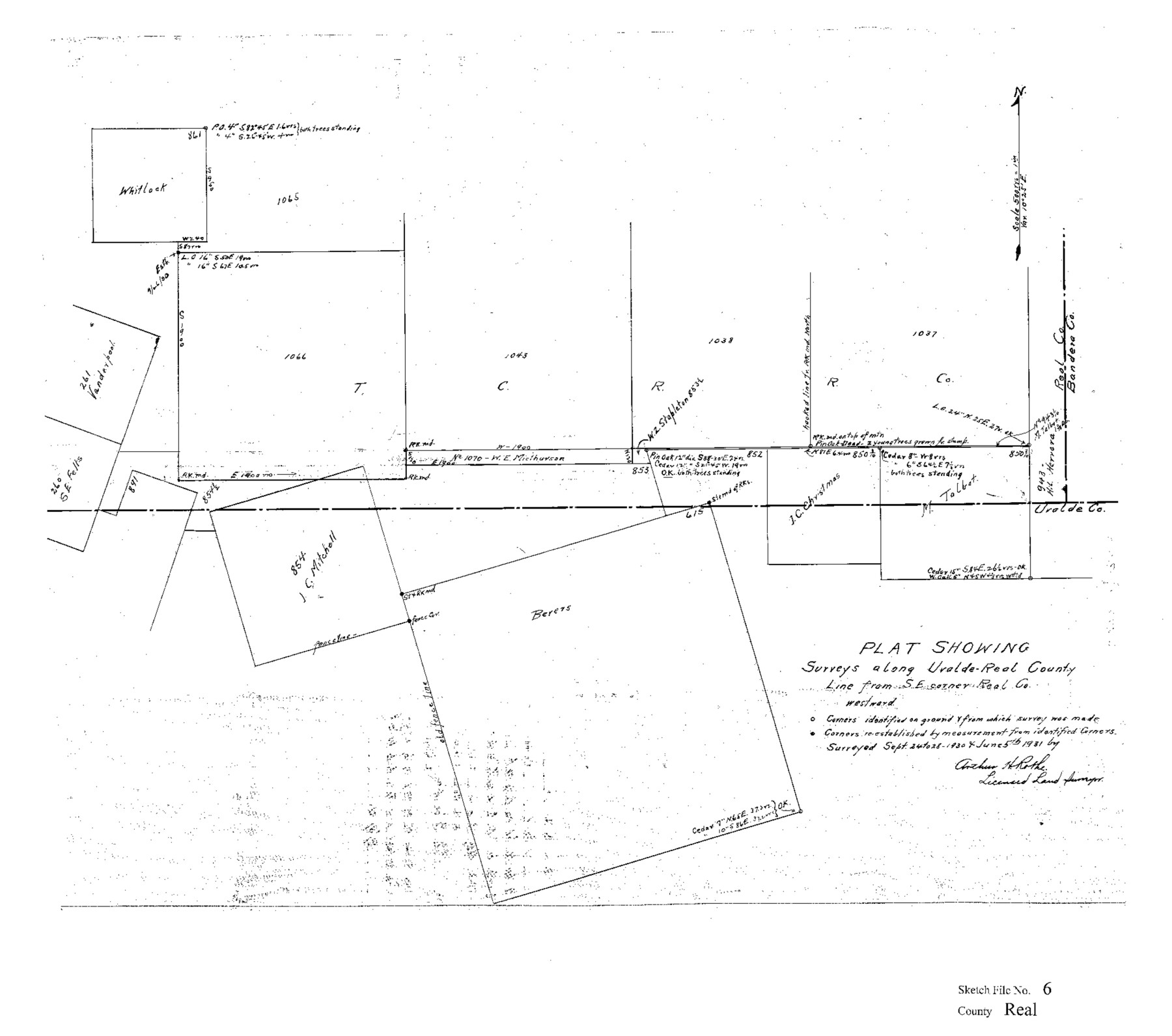
Real County Sketch File 6
Plat showing surveys along Uvalde-Real County line from SE corner of Real Co. westward
-
Map/Doc
12229
-
Collection
General Map Collection
-
Object Dates
1931 (Creation Date)
8/3/1931 (File Date)
9/24 - 9/28 1930 (Survey Date)
6/5/1931 (Survey Date)
-
People and Organizations
Arthur H. Rothe (Surveyor/Engineer)
-
Counties
Real Uvalde
-
Subjects
Surveying Sketch File
-
Height x Width
17.3 x 19.6 inches
43.9 x 49.8 cm
-
Medium
paper, print
-
Comments
See Real County Sketch File 7 (35055) for surveyor reports.
Related maps
Real County Sketch File 7

Print $8.00
- Digital $50.00
Real County Sketch File 7
1931
Size 11.3 x 8.8 inches
Map/Doc 35055
Part of: General Map Collection
Culberson County Working Sketch 32

Print $20.00
- Digital $50.00
Culberson County Working Sketch 32
1958
Size 45.3 x 38.0 inches
Map/Doc 68485
Briscoe County Rolled Sketch 20

Print $20.00
- Digital $50.00
Briscoe County Rolled Sketch 20
1949
Size 37.4 x 21.7 inches
Map/Doc 5334
Castro County Boundary File 1b

Print $32.00
- Digital $50.00
Castro County Boundary File 1b
Size 14.1 x 8.6 inches
Map/Doc 51208
Map of Hill County

Print $40.00
- Digital $50.00
Map of Hill County
1884
Size 80.0 x 35.2 inches
Map/Doc 93379
La Salle County Sketch File 42 and 42a

Print $28.00
- Digital $50.00
La Salle County Sketch File 42 and 42a
1926
Size 11.1 x 8.9 inches
Map/Doc 29597
Live Oak County Rolled Sketch 10A

Print $20.00
- Digital $50.00
Live Oak County Rolled Sketch 10A
1983
Size 38.4 x 43.6 inches
Map/Doc 9457
Garza County Sketch File D

Print $20.00
- Digital $50.00
Garza County Sketch File D
1901
Size 18.4 x 12.2 inches
Map/Doc 11550

El Paso County Rolled Sketch 52

Print $20.00
- Digital $50.00
El Paso County Rolled Sketch 52
1932
Size 18.3 x 24.3 inches
Map/Doc 5843
Victoria County Rolled Sketch 2

Print $40.00
- Digital $50.00
Victoria County Rolled Sketch 2
1940
Size 61.1 x 18.5 inches
Map/Doc 10093
Deaf Smith County Working Sketch 6

Print $20.00
- Digital $50.00
Deaf Smith County Working Sketch 6
2019
Size 36.5 x 24.5 inches
Map/Doc 95408
Coke County Sketch File 10

Print $6.00
- Digital $50.00
Coke County Sketch File 10
1892
Size 10.7 x 8.1 inches
Map/Doc 18587
You may also like
Burnet County Working Sketch 10

Print $20.00
- Digital $50.00
Burnet County Working Sketch 10
1975
Size 18.6 x 20.3 inches
Map/Doc 67853
Liberty County Sketch File AX

Print $10.00
- Digital $50.00
Liberty County Sketch File AX
1899
Size 14.1 x 8.5 inches
Map/Doc 30061
Crockett County Rolled Sketch 44

Print $20.00
- Digital $50.00
Crockett County Rolled Sketch 44
Size 44.5 x 36.8 inches
Map/Doc 76170
Montgomery County Working Sketch 62

Print $20.00
- Digital $50.00
Montgomery County Working Sketch 62
1963
Size 18.1 x 21.3 inches
Map/Doc 71169
Coke County Rolled Sketch 12A

Print $20.00
- Digital $50.00
Coke County Rolled Sketch 12A
1949
Size 21.1 x 23.4 inches
Map/Doc 5513
Jeff Davis County Rolled Sketch 23A

Print $11.00
- Digital $50.00
Jeff Davis County Rolled Sketch 23A
1886
Size 9.9 x 15.3 inches
Map/Doc 46293
Austin County Working Sketch 8

Print $20.00
- Digital $50.00
Austin County Working Sketch 8
1992
Size 28.7 x 31.6 inches
Map/Doc 67249
Pecos County Working Sketch 128

Print $20.00
- Digital $50.00
Pecos County Working Sketch 128
1975
Size 20.4 x 21.5 inches
Map/Doc 71602
Nueces County

Print $20.00
- Digital $50.00
Nueces County
1913
Size 23.5 x 32.3 inches
Map/Doc 77385
Stephens County Boundary File 3

Print $25.00
- Digital $50.00
Stephens County Boundary File 3
Size 14.2 x 8.8 inches
Map/Doc 58882
Flight Mission No. DAG-14K, Frame 42, Matagorda County

Print $20.00
- Digital $50.00
Flight Mission No. DAG-14K, Frame 42, Matagorda County
1952
Size 18.5 x 22.3 inches
Map/Doc 86300
Harris County Rolled Sketch 87

Print $40.00
- Digital $50.00
Harris County Rolled Sketch 87
Size 45.2 x 49.8 inches
Map/Doc 9141