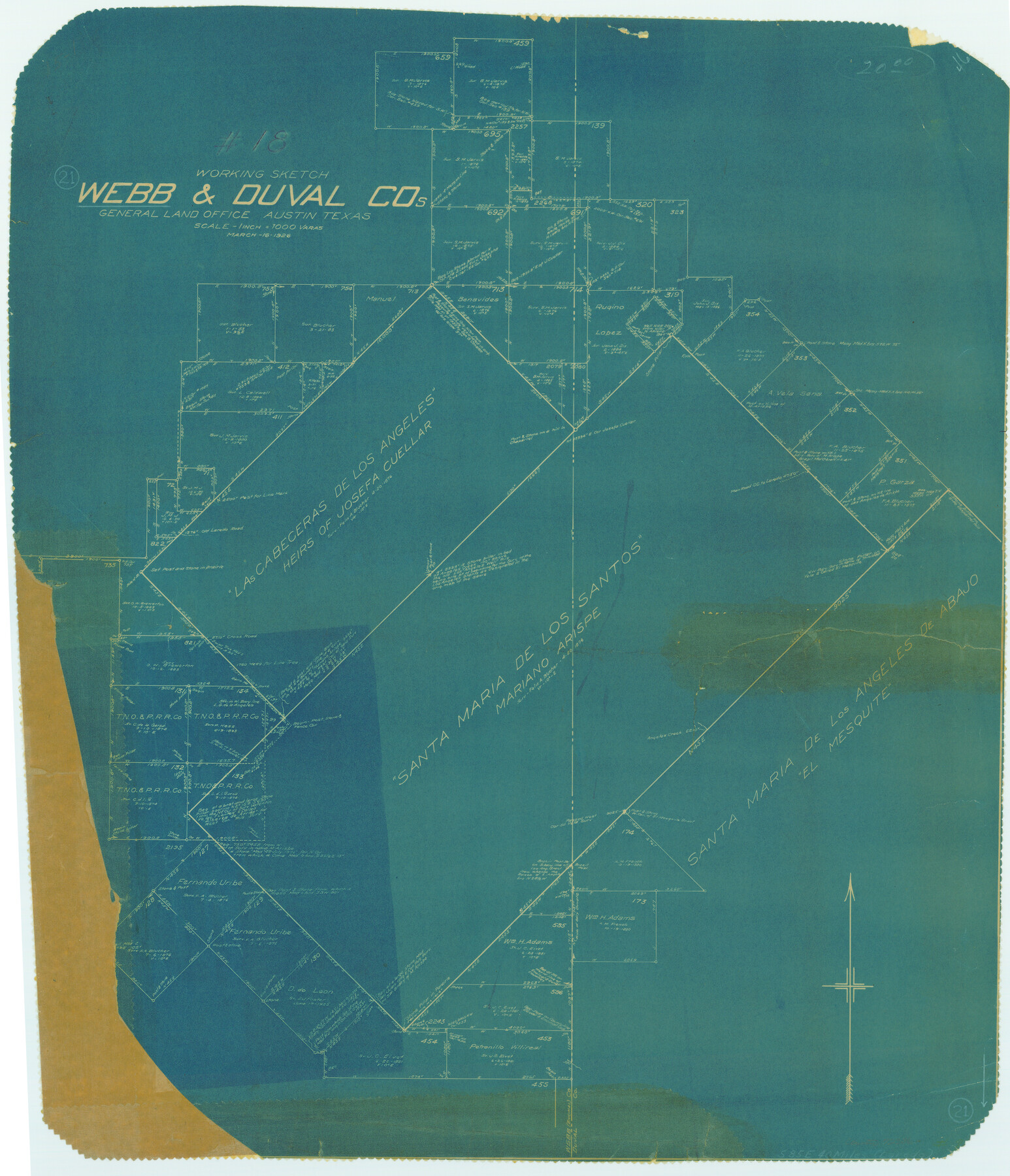
Webb County Working Sketch 21
-
Map/Doc
72386
-
Collection
General Map Collection
-
Object Dates
3/16/1926 (Creation Date)
-
Counties
Webb Duval
-
Subjects
Surveying Working Sketch
-
Height x Width
28.7 x 24.7 inches
72.9 x 62.7 cm
-
Scale
1" = 1000 varas
Part of: General Map Collection
Brewster County Working Sketch 49

Print $20.00
- Digital $50.00
Brewster County Working Sketch 49
1949
Size 37.1 x 22.6 inches
Map/Doc 67583
Flight Mission No. CRE-2R, Frame 160, Jackson County

Print $20.00
- Digital $50.00
Flight Mission No. CRE-2R, Frame 160, Jackson County
1956
Size 18.5 x 22.3 inches
Map/Doc 85371

Kerr County State Real Property Sketch 2

Print $2.00
- Digital $50.00
Kerr County State Real Property Sketch 2
2007
Size 10.7 x 8.6 inches
Map/Doc 88675
Hudspeth County Working Sketch 32

Print $20.00
- Digital $50.00
Hudspeth County Working Sketch 32
1972
Size 21.6 x 31.7 inches
Map/Doc 66316
Glasscock County Sketch File 18

Print $8.00
- Digital $50.00
Glasscock County Sketch File 18
1931
Size 9.7 x 6.2 inches
Map/Doc 24192
Flight Mission No. DQO-2K, Frame 139, Galveston County

Print $20.00
- Digital $50.00
Flight Mission No. DQO-2K, Frame 139, Galveston County
1952
Size 18.8 x 22.5 inches
Map/Doc 85036
Flight Mission No. BQR-13K, Frame 161, Brazoria County

Print $20.00
- Digital $50.00
Flight Mission No. BQR-13K, Frame 161, Brazoria County
1952
Size 18.7 x 22.3 inches
Map/Doc 84086
Jeff Davis County Sketch File 46

Print $8.00
- Digital $50.00
Jeff Davis County Sketch File 46
1906
Size 13.5 x 8.8 inches
Map/Doc 28080
Bosque County Sketch File 16

Print $14.00
- Digital $50.00
Bosque County Sketch File 16
Size 13.0 x 7.9 inches
Map/Doc 14781
Crane County Sketch File 11

Print $40.00
- Digital $50.00
Crane County Sketch File 11
Size 18.5 x 8.9 inches
Map/Doc 19569
Travis County Sketch File 8

Print $4.00
- Digital $50.00
Travis County Sketch File 8
Size 10.2 x 8.1 inches
Map/Doc 38288
You may also like
Calhoun County NRC Article 33.136 Sketch 7

Print $63.00
- Digital $50.00
Calhoun County NRC Article 33.136 Sketch 7
2016
Size 17.1 x 21.8 inches
Map/Doc 94867
Louisiana and Texas Intracoastal Waterway, Section 7, Galveston Bay to Brazos River and Section 8, Brazos River to Matagorda Bay

Print $20.00
- Digital $50.00
Louisiana and Texas Intracoastal Waterway, Section 7, Galveston Bay to Brazos River and Section 8, Brazos River to Matagorda Bay
1928
Size 31.3 x 42.7 inches
Map/Doc 73065
Limestone County Working Sketch 5

Print $20.00
- Digital $50.00
Limestone County Working Sketch 5
1922
Size 21.2 x 28.9 inches
Map/Doc 70555
A Map of North America, constructed according to the latest information

Print $40.00
- Digital $50.00
A Map of North America, constructed according to the latest information
1822
Size 44.4 x 59.6 inches
Map/Doc 93845
Bird's Eye View of the City of Houston, Texas

Print $20.00
Bird's Eye View of the City of Houston, Texas
1873
Size 24.0 x 30.9 inches
Map/Doc 89093
Map of Wilbarger County

Print $40.00
- Digital $50.00
Map of Wilbarger County
1887
Size 52.2 x 47.0 inches
Map/Doc 16926
Map of a Route from Austin-City to Paso del Norte & c.

Print $20.00
- Digital $50.00
Map of a Route from Austin-City to Paso del Norte & c.
1849
Size 11.7 x 30.5 inches
Map/Doc 2121
Texas Coordinate File 4

Print $44.00
- Digital $50.00
Texas Coordinate File 4
Size 11.4 x 9.1 inches
Map/Doc 75308
Republic Counties. January 1, 1838

Print $20.00
Republic Counties. January 1, 1838
2020
Size 24.5 x 21.7 inches
Map/Doc 96311
Hood County Sketch File 19

Print $11.00
- Digital $50.00
Hood County Sketch File 19
Size 9.0 x 7.9 inches
Map/Doc 26603
Jones County Working Sketch 2

Print $20.00
- Digital $50.00
Jones County Working Sketch 2
1928
Size 19.9 x 22.2 inches
Map/Doc 66640
[Nathaniel H. Cochran Survey and Vicinity]
![91494, [Nathaniel H. Cochran Survey and Vicinity], Twichell Survey Records](https://historictexasmaps.com/wmedia_w700/maps/91494-1.tif.jpg)
Print $20.00
- Digital $50.00
[Nathaniel H. Cochran Survey and Vicinity]
Size 26.7 x 18.8 inches
Map/Doc 91494