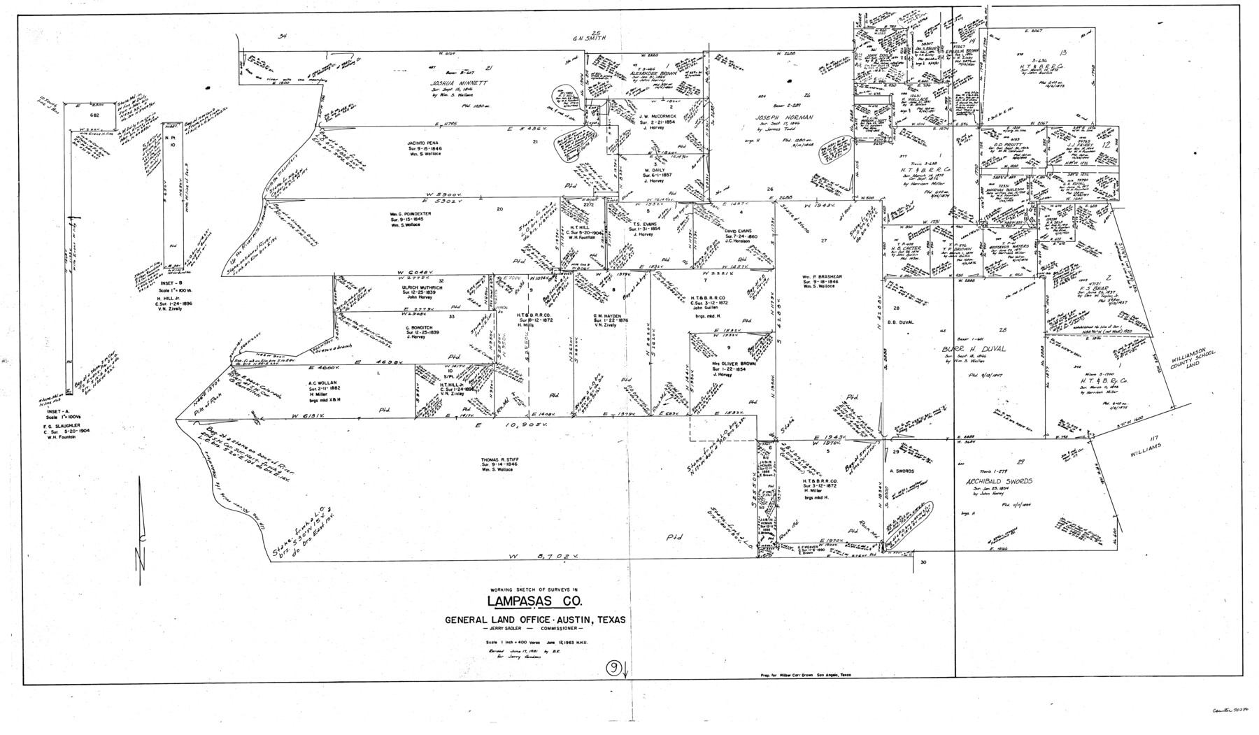
Lampasas County Working Sketch 9
-
Map/Doc
70286
-
Collection
General Map Collection
-
Object Dates
6/12/1963 (Creation Date)
-
People and Organizations
Herbert H. Ulbricht (Draftsman)
Beverly Robison (Draftsman)
-
Counties
Lampasas
-
Subjects
Surveying Working Sketch
-
Height x Width
32.9 x 56.3 inches
83.6 x 143.0 cm
-
Scale
1" = 400 varas
Part of: General Map Collection
Brazoria County Sketch File 8

Print $4.00
- Digital $50.00
Brazoria County Sketch File 8
1874
Size 12.4 x 8.4 inches
Map/Doc 14934
McLennan County Sketch File 23

Print $4.00
- Digital $50.00
McLennan County Sketch File 23
Size 5.6 x 3.2 inches
Map/Doc 31297
Sabine Pass and Lake

Print $20.00
- Digital $50.00
Sabine Pass and Lake
1925
Size 43.6 x 28.0 inches
Map/Doc 69821
[Surveys near Calaveras Creek]
![364, [Surveys near Calaveras Creek], General Map Collection](https://historictexasmaps.com/wmedia_w700/maps/364.tif.jpg)
Print $2.00
- Digital $50.00
[Surveys near Calaveras Creek]
1846
Size 10.9 x 8.0 inches
Map/Doc 364
Map of Polk Co.

Print $40.00
- Digital $50.00
Map of Polk Co.
1906
Size 52.0 x 43.0 inches
Map/Doc 16789
Flight Mission No. CRC-3R, Frame 16, Chambers County

Print $20.00
- Digital $50.00
Flight Mission No. CRC-3R, Frame 16, Chambers County
1956
Size 18.6 x 22.2 inches
Map/Doc 84790
Sherman County

Print $20.00
- Digital $50.00
Sherman County
1932
Size 38.7 x 36.3 inches
Map/Doc 73289
Flight Mission No. DQN-2K, Frame 25, Calhoun County

Print $20.00
- Digital $50.00
Flight Mission No. DQN-2K, Frame 25, Calhoun County
1953
Size 18.8 x 22.4 inches
Map/Doc 84232
Flight Mission No. CLL-3N, Frame 3, Willacy County

Print $20.00
- Digital $50.00
Flight Mission No. CLL-3N, Frame 3, Willacy County
1954
Size 18.6 x 22.3 inches
Map/Doc 87069
Runnels County Rolled Sketch 38

Print $20.00
- Digital $50.00
Runnels County Rolled Sketch 38
1950
Size 33.9 x 46.6 inches
Map/Doc 7524
Stonewall County Boundary File 4a

Print $18.00
- Digital $50.00
Stonewall County Boundary File 4a
Size 14.2 x 8.8 inches
Map/Doc 58984
Runnels County Rolled Sketch 36

Print $40.00
- Digital $50.00
Runnels County Rolled Sketch 36
Size 61.2 x 43.0 inches
Map/Doc 76027
You may also like
Haskell County Rolled Sketch 6

Print $20.00
- Digital $50.00
Haskell County Rolled Sketch 6
1940
Size 22.3 x 19.6 inches
Map/Doc 6166
Maps of Gulf Intracoastal Waterway, Texas - Sabine River to the Rio Grande and connecting waterways including ship channels

Print $20.00
- Digital $50.00
Maps of Gulf Intracoastal Waterway, Texas - Sabine River to the Rio Grande and connecting waterways including ship channels
1966
Size 14.5 x 22.2 inches
Map/Doc 61969
Aransas County Sketch File 24

Print $36.00
- Digital $50.00
Aransas County Sketch File 24
1938
Size 10.9 x 8.3 inches
Map/Doc 13177
Somervell County

Print $20.00
- Digital $50.00
Somervell County
1941
Size 29.2 x 27.1 inches
Map/Doc 95642

Milam County Working Sketch 6

Print $20.00
- Digital $50.00
Milam County Working Sketch 6
1963
Size 29.1 x 23.9 inches
Map/Doc 71021
Flight Mission No. BQY-4M, Frame 124, Harris County

Print $20.00
- Digital $50.00
Flight Mission No. BQY-4M, Frame 124, Harris County
1953
Size 18.7 x 22.4 inches
Map/Doc 85292
Brewster County Rolled Sketch 59AA

Print $20.00
- Digital $50.00
Brewster County Rolled Sketch 59AA
1931
Size 19.2 x 24.0 inches
Map/Doc 5228
Val Verde County Working Sketch 17

Print $20.00
- Digital $50.00
Val Verde County Working Sketch 17
1926
Size 16.5 x 27.8 inches
Map/Doc 72152
Shackelford County Rolled Sketch 3

Print $40.00
- Digital $50.00
Shackelford County Rolled Sketch 3
1955
Size 35.4 x 49.9 inches
Map/Doc 9915
Bird's Eye View of the City of Dallas, Texas

Print $20.00
Bird's Eye View of the City of Dallas, Texas
1872
Size 18.6 x 25.6 inches
Map/Doc 89080
Fisher County Working Sketch 2

Print $20.00
- Digital $50.00
Fisher County Working Sketch 2
1920
Size 23.0 x 18.2 inches
Map/Doc 69136