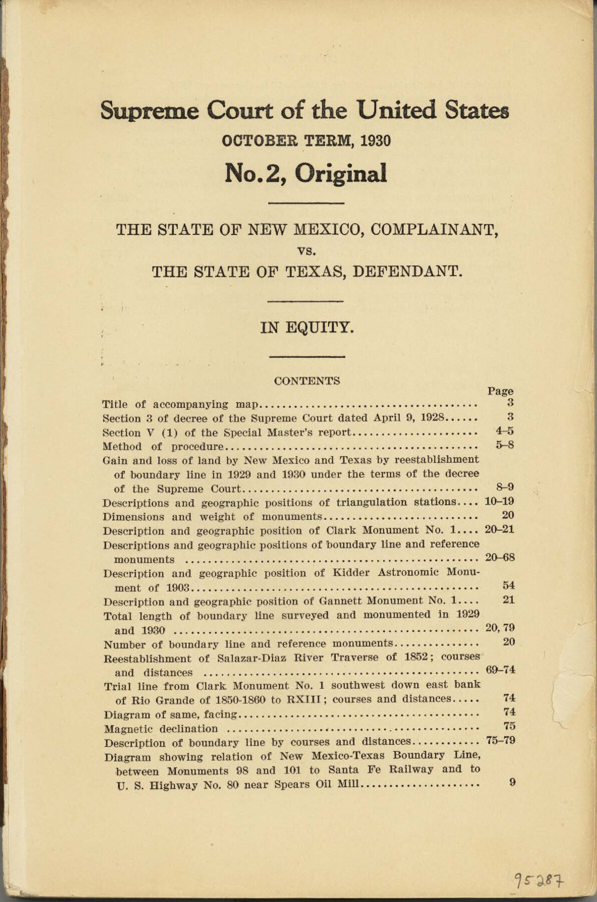
Supreme Court of the United States, October Term, 1930, No.2, Original - The State of New Mexico, Complainant vs. The State of Texas, Defendant
-
Map/Doc
95287
-
Collection
General Map Collection
-
Object Dates
1930 (Publication Date)
-
Subjects
Legal Texas Boundaries
-
Height x Width
9.2 x 6.0 inches
23.4 x 15.2 cm
-
Medium
paper, bound volume
-
Comments
Missing original cover but includes large map called: "Map of the Boundary Line Between New Mexico and Texas in the Valley of the Rio Grande River from the parallel of 32 degrees north latitude southwardly to the parallel of 31 degrees and 47 minutes, as surveyed in 1929 and 1930, in accordance with the terms of the above-entitled cause"
Part of: General Map Collection
Surveys in Reeves and Culberson Counties, Texas and Pacific Railroad Company, Blocks 58, 59, 60, and 61

Print $20.00
- Digital $50.00
Surveys in Reeves and Culberson Counties, Texas and Pacific Railroad Company, Blocks 58, 59, 60, and 61
1937
Size 30.7 x 25.3 inches
Map/Doc 2250
Leon County Rolled Sketch 26A

Print $20.00
- Digital $50.00
Leon County Rolled Sketch 26A
1988
Size 21.5 x 34.4 inches
Map/Doc 6611
Flight Mission No. BQR-4K, Frame 64, Brazoria County

Print $20.00
- Digital $50.00
Flight Mission No. BQR-4K, Frame 64, Brazoria County
1952
Size 18.7 x 22.4 inches
Map/Doc 83997
Jack County Sketch File 12

Print $9.00
- Digital $50.00
Jack County Sketch File 12
Size 5.6 x 8.3 inches
Map/Doc 27533
Fayette County Sketch File 4

Print $4.00
- Digital $50.00
Fayette County Sketch File 4
Size 11.7 x 7.9 inches
Map/Doc 22504
Reeves County

Print $40.00
- Digital $50.00
Reeves County
1915
Size 48.4 x 38.7 inches
Map/Doc 66999
Current Miscellaneous File 40

Print $10.00
- Digital $50.00
Current Miscellaneous File 40
Size 14.2 x 8.7 inches
Map/Doc 73972
Copy of Surveyor's Field Book, Morris Browning - In Blocks 7, 5 & 4, I&GNRRCo., Hutchinson and Carson Counties, Texas

Print $2.00
- Digital $50.00
Copy of Surveyor's Field Book, Morris Browning - In Blocks 7, 5 & 4, I&GNRRCo., Hutchinson and Carson Counties, Texas
1888
Size 6.9 x 8.8 inches
Map/Doc 62280
Dickens County Sketch File 38

Print $4.00
- Digital $50.00
Dickens County Sketch File 38
1904
Size 10.8 x 7.3 inches
Map/Doc 21048
Ward County Rolled Sketch 15

Print $20.00
- Digital $50.00
Ward County Rolled Sketch 15
1941
Size 26.9 x 39.2 inches
Map/Doc 8158
Padre Island National Seashore

Print $4.00
- Digital $50.00
Padre Island National Seashore
Size 16.1 x 22.3 inches
Map/Doc 60535
Nueces River, Calallen Sheet

Print $20.00
- Digital $50.00
Nueces River, Calallen Sheet
1927
Size 32.7 x 37.3 inches
Map/Doc 65087
You may also like
Brazoria County Working Sketch 38

Print $40.00
- Digital $50.00
Brazoria County Working Sketch 38
1981
Size 53.2 x 37.7 inches
Map/Doc 67523
Topographical Map of the City of Austin

Print $20.00
- Digital $50.00
Topographical Map of the City of Austin
1887
Size 43.1 x 41.1 inches
Map/Doc 2189
Lubbock County Boundary File 10

Print $108.00
- Digital $50.00
Lubbock County Boundary File 10
Size 14.3 x 8.7 inches
Map/Doc 56549
Coke County Sketch File 23

Print $20.00
- Digital $50.00
Coke County Sketch File 23
Size 43.9 x 18.5 inches
Map/Doc 10338
Montague County

Print $20.00
- Digital $50.00
Montague County
1924
Size 46.9 x 33.7 inches
Map/Doc 73243
Brown County Sketch File 17

Print $40.00
- Digital $50.00
Brown County Sketch File 17
Size 15.6 x 12.7 inches
Map/Doc 16614
Tom Green County Rolled Sketch 7

Print $20.00
- Digital $50.00
Tom Green County Rolled Sketch 7
Size 37.0 x 40.0 inches
Map/Doc 9998
Trinity River, Levee Improvements, District Widths of Floodways

Print $20.00
- Digital $50.00
Trinity River, Levee Improvements, District Widths of Floodways
1920
Size 25.0 x 18.6 inches
Map/Doc 65252
Bexar County Working Sketch 16

Print $20.00
- Digital $50.00
Bexar County Working Sketch 16
1978
Size 23.0 x 44.5 inches
Map/Doc 67332
Hudspeth County Working Sketch 27

Print $40.00
- Digital $50.00
Hudspeth County Working Sketch 27
1972
Size 31.0 x 51.2 inches
Map/Doc 66309
[H. & G. N. RR. Company, Block B3]
![90718, [H. & G. N. RR. Company, Block B3], Twichell Survey Records](https://historictexasmaps.com/wmedia_w700/maps/90718-1.tif.jpg)
Print $20.00
- Digital $50.00
[H. & G. N. RR. Company, Block B3]
Size 34.9 x 28.8 inches
Map/Doc 90718
Franklin County Working Sketch 1

Print $20.00
- Digital $50.00
Franklin County Working Sketch 1
1915
Size 20.4 x 11.8 inches
Map/Doc 69239