Current Miscellaneous File 40
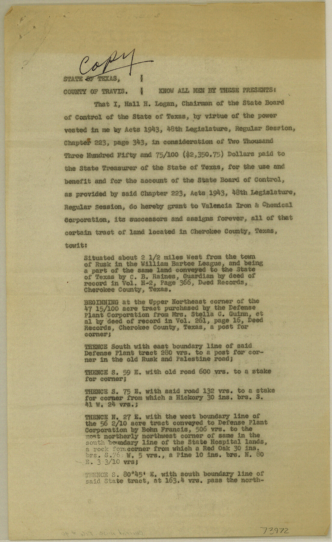
Sale of 83.63 acres of land out of Wm. Bartee League, Cherokee County to Valencia Iron and Chemical Corp as provided by Charter 223, Acts 1943, 48th Legislature, Regular Session
-
Map/Doc
73972
-
Collection
General Map Collection
-
Subjects
Legal
-
Height x Width
14.2 x 8.7 inches
36.1 x 22.1 cm
Part of: General Map Collection
Lamb County Sketch File A

Print $20.00
- Digital $50.00
Lamb County Sketch File A
1902
Size 30.8 x 38.7 inches
Map/Doc 10518
Flight Mission No. BQR-4K, Frame 58, Brazoria County

Print $20.00
- Digital $50.00
Flight Mission No. BQR-4K, Frame 58, Brazoria County
1952
Size 18.7 x 22.4 inches
Map/Doc 83991
Drainage Basins of Texas Streams

Print $20.00
- Digital $50.00
Drainage Basins of Texas Streams
Size 17.0 x 19.3 inches
Map/Doc 65269

DeWitt County Sketch File 14

Print $8.00
- Digital $50.00
DeWitt County Sketch File 14
1873
Size 12.8 x 8.2 inches
Map/Doc 20827
Cass County Working Sketch 42

Print $20.00
- Digital $50.00
Cass County Working Sketch 42
1986
Size 36.4 x 37.5 inches
Map/Doc 67945
Cochran County Sketch File 6

Print $10.00
- Digital $50.00
Cochran County Sketch File 6
1938
Size 11.2 x 8.6 inches
Map/Doc 18545
Calhoun County Rolled Sketch 30

Print $20.00
- Digital $50.00
Calhoun County Rolled Sketch 30
1974
Size 18.8 x 27.6 inches
Map/Doc 5494
Pecos County Rolled Sketch 19

Print $21.00
- Digital $50.00
Pecos County Rolled Sketch 19
1885
Size 9.4 x 14.7 inches
Map/Doc 48082
Lampasas County Sketch File 5

Print $8.00
- Digital $50.00
Lampasas County Sketch File 5
1869
Size 12.8 x 7.9 inches
Map/Doc 29396
Freestone County Working Sketch 1

Print $20.00
- Digital $50.00
Freestone County Working Sketch 1
1913
Size 20.2 x 27.2 inches
Map/Doc 69243
Gulf Oil Corp. Fishgide - Port Isabel

Gulf Oil Corp. Fishgide - Port Isabel
1960
Size 12.1 x 22.4 inches
Map/Doc 75981
You may also like
Cochran County Working Sketch Graphic Index

Print $20.00
- Digital $50.00
Cochran County Working Sketch Graphic Index
1946
Size 31.9 x 23.9 inches
Map/Doc 76495
Wilson County Sketch File 11

Print $27.00
- Digital $50.00
Wilson County Sketch File 11
Size 19.5 x 23.6 inches
Map/Doc 40419
Milam County Working Sketch 13

Print $20.00
- Digital $50.00
Milam County Working Sketch 13
2004
Size 34.1 x 46.0 inches
Map/Doc 83578
Navarro County Boundary File 1a

Print $42.00
- Digital $50.00
Navarro County Boundary File 1a
Size 9.5 x 6.1 inches
Map/Doc 57605
Flight Mission No. BRA-7M, Frame 32, Jefferson County

Print $20.00
- Digital $50.00
Flight Mission No. BRA-7M, Frame 32, Jefferson County
1953
Size 18.7 x 22.4 inches
Map/Doc 85483
Eastland County Working Sketch 44

Print $20.00
- Digital $50.00
Eastland County Working Sketch 44
1979
Size 28.8 x 23.5 inches
Map/Doc 68825
[Neches River Bed, Plat and Calculations]
![77100, [Neches River Bed, Plat and Calculations], General Map Collection](https://historictexasmaps.com/wmedia_w700/maps/77100.tif.jpg)
Print $20.00
- Digital $50.00
[Neches River Bed, Plat and Calculations]
1928
Size 25.6 x 37.2 inches
Map/Doc 77100
Brewster County Sketch File N-19

Print $40.00
- Digital $50.00
Brewster County Sketch File N-19
1946
Size 18.7 x 26.2 inches
Map/Doc 10966
Jack County Sketch File 3

Print $6.00
- Digital $50.00
Jack County Sketch File 3
1857
Size 10.6 x 16.5 inches
Map/Doc 27504
Garza County Rolled Sketch 12

Print $20.00
- Digital $50.00
Garza County Rolled Sketch 12
1916
Size 31.5 x 26.0 inches
Map/Doc 6069
Ochiltree County Boundary File 9

Print $18.00
- Digital $50.00
Ochiltree County Boundary File 9
Size 11.2 x 8.7 inches
Map/Doc 57719
Flight Mission No. DAG-22K, Frame 84, Matagorda County

Print $20.00
- Digital $50.00
Flight Mission No. DAG-22K, Frame 84, Matagorda County
1953
Size 15.7 x 15.6 inches
Map/Doc 86468