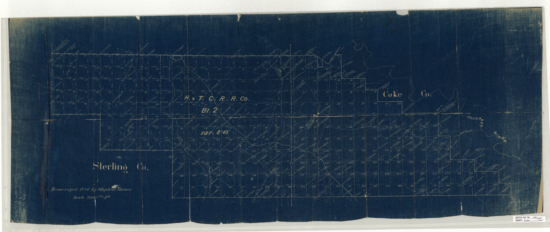
Coke County Sketch File 23
[Sketch of H. & T. C. R.R. Co. Block 2 in Coke and Sterling Counties]
-
Map/Doc
10338
-
Collection
General Map Collection
-
Object Dates
1926/4/19 (File Date)
1886 (Survey Date)
-
People and Organizations
Stephen Turner (Surveyor/Engineer)
-
Counties
Coke Sterling
-
Subjects
Surveying Sketch File
-
Height x Width
43.9 x 18.5 inches
111.5 x 47.0 cm
-
Medium
blueprint/diazo
-
Scale
1" = 2000 varas
-
Features
Willow Creek
Colorado River
Salt Branch of Colorado River
Paint Creek
Pecan Creek
Cox Hollow Creek
McKenzie Creek
Part of: General Map Collection
Jefferson County Sketch File 15a

Print $8.00
- Digital $50.00
Jefferson County Sketch File 15a
1872
Size 15.6 x 6.7 inches
Map/Doc 28156
Jefferson County Sketch File 5b

Print $6.00
- Digital $50.00
Jefferson County Sketch File 5b
1860
Size 9.3 x 11.1 inches
Map/Doc 28108
Hays County Boundary File

Print $120.00
- Digital $50.00
Hays County Boundary File
1947
Size 33.6 x 20.8 inches
Map/Doc 65496
Wood County Working Sketch 12

Print $20.00
- Digital $50.00
Wood County Working Sketch 12
1964
Size 37.4 x 34.5 inches
Map/Doc 62012
Glasscock County Working Sketch 1

Print $20.00
- Digital $50.00
Glasscock County Working Sketch 1
Size 26.6 x 43.0 inches
Map/Doc 63174
Right of Way and Track Map, the Missouri, Kansas and Texas Ry. of Texas - Henrietta Division

Print $20.00
- Digital $50.00
Right of Way and Track Map, the Missouri, Kansas and Texas Ry. of Texas - Henrietta Division
1918
Size 11.8 x 27.0 inches
Map/Doc 64761
Flight Mission No. BQR-9K, Frame 46, Brazoria County

Print $20.00
- Digital $50.00
Flight Mission No. BQR-9K, Frame 46, Brazoria County
1952
Size 18.7 x 22.3 inches
Map/Doc 84050
Coleman County Sketch File 19

Print $4.00
- Digital $50.00
Coleman County Sketch File 19
Size 12.5 x 8.1 inches
Map/Doc 18692
Map of Fannin County

Print $20.00
- Digital $50.00
Map of Fannin County
1866
Size 21.9 x 18.1 inches
Map/Doc 3534
Haskell County Rolled Sketch 15

Print $20.00
- Digital $50.00
Haskell County Rolled Sketch 15
1991
Size 12.7 x 18.4 inches
Map/Doc 6173
Midland County Rolled Sketch 6

Print $20.00
- Digital $50.00
Midland County Rolled Sketch 6
1951
Size 39.8 x 28.6 inches
Map/Doc 6764
Liberty County Sketch File 61

Print $12.00
- Digital $50.00
Liberty County Sketch File 61
1950
Size 14.2 x 8.8 inches
Map/Doc 30077
You may also like
[Ezekiel Ables and surrounding surveys]
![90966, [Ezekiel Ables and surrounding surveys], Twichell Survey Records](https://historictexasmaps.com/wmedia_w700/maps/90966-1.tif.jpg)
Print $20.00
- Digital $50.00
[Ezekiel Ables and surrounding surveys]
Size 12.6 x 18.0 inches
Map/Doc 90966
Texas Gulf Coast Map from the Sabine River to the Rio Grande as subdivided for mineral development

Print $20.00
- Digital $50.00
Texas Gulf Coast Map from the Sabine River to the Rio Grande as subdivided for mineral development
1966
Size 29.1 x 41.7 inches
Map/Doc 2496
Outer Continental Shelf Leasing Maps (Texas Offshore Operations)

Print $20.00
- Digital $50.00
Outer Continental Shelf Leasing Maps (Texas Offshore Operations)
Size 17.7 x 14.1 inches
Map/Doc 75855
San Jacinto County Working Sketch 7

Print $20.00
- Digital $50.00
San Jacinto County Working Sketch 7
1935
Size 32.0 x 41.4 inches
Map/Doc 63720
Chambers County Boundary File 2

Print $18.00
- Digital $50.00
Chambers County Boundary File 2
Size 7.0 x 8.6 inches
Map/Doc 51240
Proceedings of The International (Water) Boundary Commission United States and Mexico Treaties of 1884 and 1889, Volume 2

Proceedings of The International (Water) Boundary Commission United States and Mexico Treaties of 1884 and 1889, Volume 2
Map/Doc 83145
San Jacinto County Working Sketch 11

Print $20.00
- Digital $50.00
San Jacinto County Working Sketch 11
1935
Size 40.1 x 40.0 inches
Map/Doc 63724
Travis County Boundary File 1

Print $8.00
- Digital $50.00
Travis County Boundary File 1
Size 9.0 x 14.6 inches
Map/Doc 59403
[Surveys in Austin's Colony along the San Antonio Road and the Colorado River]
![15, [Surveys in Austin's Colony along the San Antonio Road and the Colorado River], General Map Collection](https://historictexasmaps.com/wmedia_w700/maps/15.tif.jpg)
Print $20.00
- Digital $50.00
[Surveys in Austin's Colony along the San Antonio Road and the Colorado River]
1821
Size 17.3 x 25.6 inches
Map/Doc 15
Flight Mission No. CRC-5R, Frame 16, Chambers County

Print $20.00
- Digital $50.00
Flight Mission No. CRC-5R, Frame 16, Chambers County
1956
Size 18.6 x 22.4 inches
Map/Doc 84938
[Blks. B9, J, D19, John Walker]
![90480, [Blks. B9, J, D19, John Walker], Twichell Survey Records](https://historictexasmaps.com/wmedia_w700/maps/90480-1.tif.jpg)
Print $20.00
- Digital $50.00
[Blks. B9, J, D19, John Walker]
Size 28.6 x 15.9 inches
Map/Doc 90480
El Paso County Working Sketch 50

Print $20.00
- Digital $50.00
El Paso County Working Sketch 50
1991
Size 25.9 x 27.7 inches
Map/Doc 69072