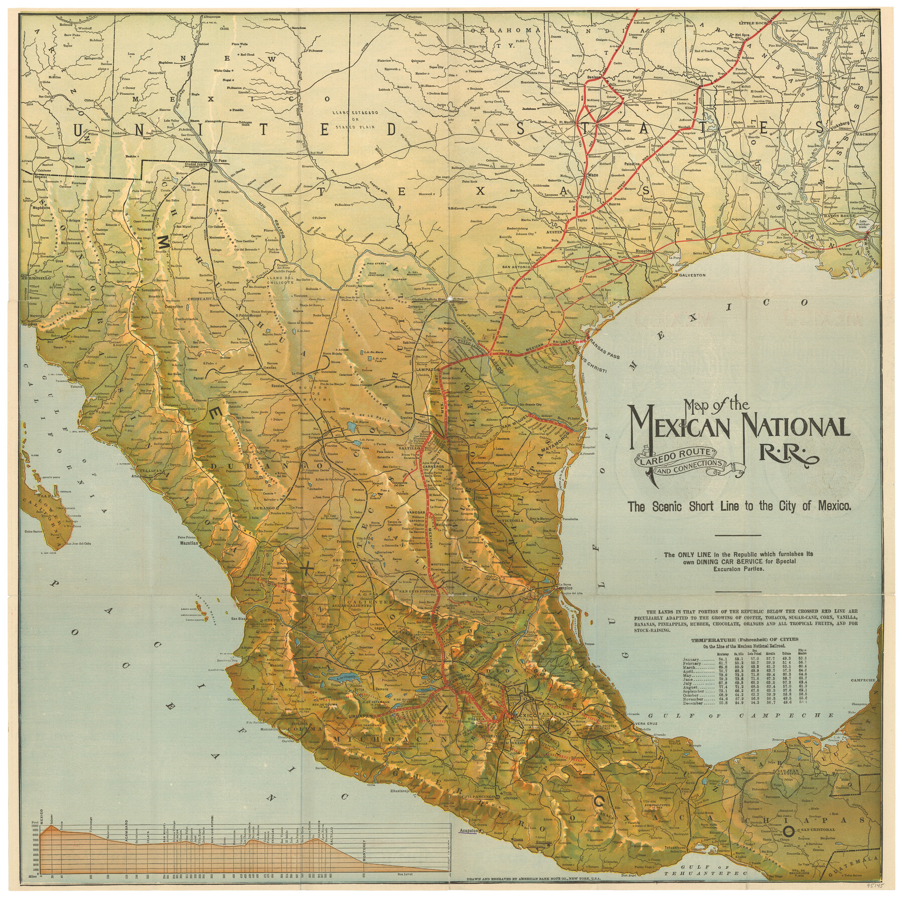
Map of the Mexican National R.R. "Laredo Route" and Connections. The Scenic Short Line to the City of Mexico
[recto - map]
-
Map/Doc
95145
-
Collection
General Map Collection
-
Object Dates
1901 (Publication Date)
-
People and Organizations
Mexican National R.R. (Publisher)
American Bank Note Co. (Printer)
-
Subjects
Mexico Railroads State of Texas
-
Height x Width
24.2 x 24.3 inches
61.5 x 61.7 cm
-
Medium
paper, etching/engraving/lithograph
-
Comments
To view/download time tables and other information about the railroad on verso, please click the "Download PDF" link above.
Part of: General Map Collection
Map of Texas and New Orleans R.R. or Sabine and Galveston Bay Rail Road

Print $40.00
- Digital $50.00
Map of Texas and New Orleans R.R. or Sabine and Galveston Bay Rail Road
1859
Size 17.0 x 59.1 inches
Map/Doc 64091
Harris County

Print $40.00
- Digital $50.00
Harris County
1896
Size 44.8 x 67.5 inches
Map/Doc 66856
Kent County Rolled Sketch 8

Print $20.00
- Digital $50.00
Kent County Rolled Sketch 8
1873
Size 31.5 x 35.5 inches
Map/Doc 9344
Hudspeth County Working Sketch 51

Print $20.00
- Digital $50.00
Hudspeth County Working Sketch 51
Size 32.8 x 24.5 inches
Map/Doc 66336
Orange County Sketch File B

Print $20.00
- Digital $50.00
Orange County Sketch File B
1890
Size 17.6 x 26.0 inches
Map/Doc 12130
Kendall County Sketch File 13

Print $4.00
- Digital $50.00
Kendall County Sketch File 13
1860
Size 10.1 x 8.0 inches
Map/Doc 28699
Duval County Working Sketch 25

Print $20.00
- Digital $50.00
Duval County Working Sketch 25
1946
Size 23.7 x 20.1 inches
Map/Doc 68749
Cooke County Sketch File 31

Print $22.00
- Digital $50.00
Cooke County Sketch File 31
1873
Size 8.0 x 12.9 inches
Map/Doc 19293
Map of Unsurveyed Bed of Spring Creek

Print $40.00
- Digital $50.00
Map of Unsurveyed Bed of Spring Creek
1920
Size 78.7 x 27.1 inches
Map/Doc 65695
[Surveys possibly in Austin County]
![78356, [Surveys possibly in Austin County], General Map Collection](https://historictexasmaps.com/wmedia_w700/maps/78356.tif.jpg)
Print $3.00
- Digital $50.00
[Surveys possibly in Austin County]
Size 17.0 x 9.6 inches
Map/Doc 78356
Calhoun County NRC Article 33.136 Sketch 14

Print $24.00
Calhoun County NRC Article 33.136 Sketch 14
2023
Map/Doc 97273
Presidio County Sketch File 91

Print $40.00
- Digital $50.00
Presidio County Sketch File 91
Size 12.3 x 15.9 inches
Map/Doc 34763
You may also like
Eastland County Working Sketch 16

Print $20.00
- Digital $50.00
Eastland County Working Sketch 16
1919
Size 19.1 x 16.7 inches
Map/Doc 68797
Aransas County Rolled Sketch 2

Print $40.00
- Digital $50.00
Aransas County Rolled Sketch 2
Size 42.9 x 48.2 inches
Map/Doc 73614
Tyler County Sketch File 16

Print $6.00
- Digital $50.00
Tyler County Sketch File 16
1860
Size 9.4 x 11.8 inches
Map/Doc 38661
Denton County, Texas

Print $20.00
- Digital $50.00
Denton County, Texas
1870
Size 18.6 x 22.7 inches
Map/Doc 723
Erath County Sketch File 26

Print $6.00
- Digital $50.00
Erath County Sketch File 26
1896
Size 9.5 x 8.1 inches
Map/Doc 22306
Mills County Working Sketch 24

Print $20.00
- Digital $50.00
Mills County Working Sketch 24
1988
Size 40.3 x 36.5 inches
Map/Doc 71054
Roberts County Working Sketch 1

Print $20.00
- Digital $50.00
Roberts County Working Sketch 1
1922
Size 17.6 x 17.7 inches
Map/Doc 63527
Duval County Sketch File 42

Print $4.00
- Digital $50.00
Duval County Sketch File 42
1936
Size 14.4 x 8.8 inches
Map/Doc 21394
![91783, [Block M-19], Twichell Survey Records](https://historictexasmaps.com/wmedia_w700/maps/91783-1.tif.jpg)
Flight Mission No. DAG-24K, Frame 136, Matagorda County

Print $20.00
- Digital $50.00
Flight Mission No. DAG-24K, Frame 136, Matagorda County
1953
Size 18.4 x 22.2 inches
Map/Doc 86554
The Republic County of Rusk. February 1, 1845

Print $20.00
The Republic County of Rusk. February 1, 1845
2020
Size 19.1 x 21.7 inches
Map/Doc 96267
Waller County

Print $40.00
- Digital $50.00
Waller County
1945
Size 48.9 x 28.4 inches
Map/Doc 95665