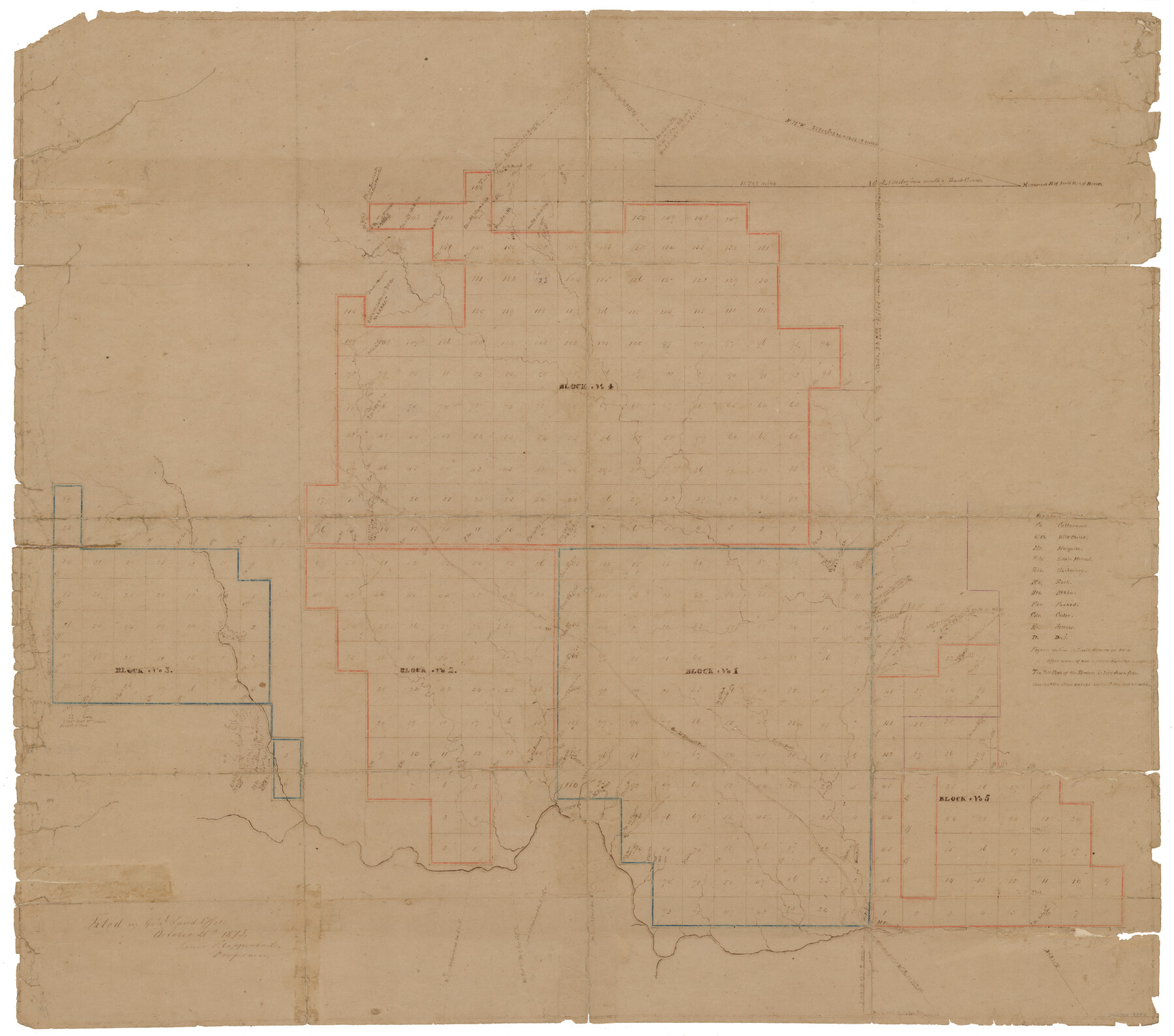
Kent County Rolled Sketch 8
[Sketch of Blocks 1, 2, 3, 4, and 5]
-
Map/Doc
9344
-
Collection
General Map Collection
-
Object Dates
1873/9/2 (Creation Date)
1873/10/26 (File Date)
-
Counties
Kent
-
Subjects
Surveying Rolled Sketch
-
Height x Width
31.5 x 35.5 inches
80.0 x 90.2 cm
-
Medium
paper, manuscript
-
Comments
Shows General McKenzie's Trail. Conservation funded in 2013 by Friends of the Texas General Land Office.
-
Features
Gen. McKenzie's Trail
Part of: General Map Collection
Map of the Western Territory &c.

Print $20.00
- Digital $50.00
Map of the Western Territory &c.
1834
Size 18.5 x 18.8 inches
Map/Doc 95691
Pecos County Working Sketch 115

Print $40.00
- Digital $50.00
Pecos County Working Sketch 115
1973
Size 54.6 x 31.8 inches
Map/Doc 71588
Donley County Working Sketch 4

Print $20.00
- Digital $50.00
Donley County Working Sketch 4
1958
Size 44.0 x 39.8 inches
Map/Doc 68737
Crockett County Working Sketch 76

Print $20.00
- Digital $50.00
Crockett County Working Sketch 76
1964
Size 34.3 x 36.3 inches
Map/Doc 68409
Hardin County Sketch File 5a

Print $6.00
- Digital $50.00
Hardin County Sketch File 5a
Size 8.1 x 3.5 inches
Map/Doc 25094
General Chart of the Coast No. XXI Gulf Coast from Galveston to the Rio Grande

Print $20.00
- Digital $50.00
General Chart of the Coast No. XXI Gulf Coast from Galveston to the Rio Grande
1883
Size 27.1 x 18.4 inches
Map/Doc 72729
Presidio County Rolled Sketch 65

Print $20.00
- Digital $50.00
Presidio County Rolled Sketch 65
Size 23.1 x 28.3 inches
Map/Doc 7356
Howard County Boundary File 2a

Print $9.00
- Digital $50.00
Howard County Boundary File 2a
Size 14.6 x 11.3 inches
Map/Doc 55118
Anderson County Sketch File 6

Print $4.00
- Digital $50.00
Anderson County Sketch File 6
Size 12.5 x 8.2 inches
Map/Doc 12753
Shackelford County Boundary File 5

Print $14.00
- Digital $50.00
Shackelford County Boundary File 5
Size 8.6 x 14.0 inches
Map/Doc 58661
Flight Mission No. BQY-4M, Frame 60, Harris County

Print $20.00
- Digital $50.00
Flight Mission No. BQY-4M, Frame 60, Harris County
1953
Size 18.6 x 22.3 inches
Map/Doc 85269
Sabine Bank to East Bay including Heald Bank

Print $20.00
- Digital $50.00
Sabine Bank to East Bay including Heald Bank
1971
Size 45.0 x 34.4 inches
Map/Doc 69849
You may also like
Flight Mission No. CUG-3P, Frame 159, Kleberg County

Print $20.00
- Digital $50.00
Flight Mission No. CUG-3P, Frame 159, Kleberg County
1956
Size 18.7 x 22.3 inches
Map/Doc 86279
[Blocks J, 24, 5, 8, 2, 1 and vicinity]
![92663, [Blocks J, 24, 5, 8, 2, 1 and vicinity], Twichell Survey Records](https://historictexasmaps.com/wmedia_w700/maps/92663-1.tif.jpg)
Print $40.00
- Digital $50.00
[Blocks J, 24, 5, 8, 2, 1 and vicinity]
Size 54.0 x 32.2 inches
Map/Doc 92663
Carson County Working Sketch 2

Print $3.00
- Digital $50.00
Carson County Working Sketch 2
1907
Size 16.7 x 10.0 inches
Map/Doc 67873
Flight Mission No. DCL-5C, Frame 70, Kenedy County

Print $20.00
- Digital $50.00
Flight Mission No. DCL-5C, Frame 70, Kenedy County
1943
Size 18.7 x 22.2 inches
Map/Doc 85853
Duval County Working Sketch 58

Print $20.00
- Digital $50.00
Duval County Working Sketch 58
Size 21.0 x 33.0 inches
Map/Doc 67498
Trinity County Sketch File 34

Print $20.00
- Digital $50.00
Trinity County Sketch File 34
Size 15.9 x 20.3 inches
Map/Doc 12491

Galveston County NRC Article 33.136 Sketch 18

Print $66.00
- Digital $50.00
Galveston County NRC Article 33.136 Sketch 18
2003
Size 22.4 x 33.9 inches
Map/Doc 78545
Flight Mission No. DAG-23K, Frame 150, Matagorda County

Print $20.00
- Digital $50.00
Flight Mission No. DAG-23K, Frame 150, Matagorda County
1953
Size 18.6 x 22.4 inches
Map/Doc 86498
Culberson County Sketch File 45

Print $6.00
- Digital $50.00
Culberson County Sketch File 45
2002
Size 14.2 x 8.8 inches
Map/Doc 76367
Map of Menard County

Print $20.00
- Digital $50.00
Map of Menard County
1871
Size 18.5 x 23.3 inches
Map/Doc 3872
