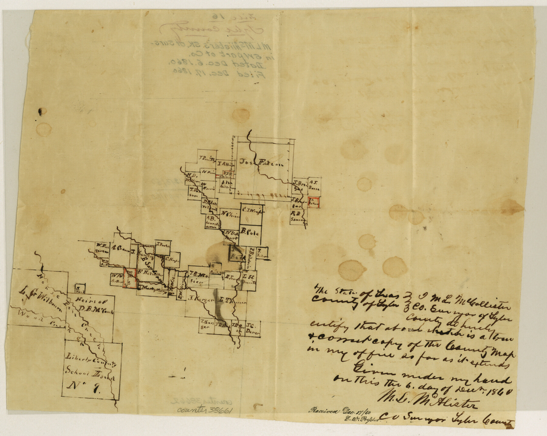
Tyler County Sketch File 16
[Sketch of surveys in the south part of the county]
-
Map/Doc
38661
-
Collection
General Map Collection
-
Object Dates
12/6/1860 (Creation Date)
12/17/1860 (File Date)
-
People and Organizations
M.L. McAlister (Surveyor/Engineer)
-
Counties
Tyler
-
Subjects
Surveying Sketch File
-
Height x Width
9.4 x 11.8 inches
23.9 x 30.0 cm
-
Medium
paper, manuscript
-
Features
Horse Pen Creek
Wood Creek
Part of: General Map Collection
Nolan County Rolled Sketch 1

Print $20.00
- Digital $50.00
Nolan County Rolled Sketch 1
Size 27.8 x 21.5 inches
Map/Doc 6859
Red River County Working Sketch 4

Print $20.00
- Digital $50.00
Red River County Working Sketch 4
1919
Size 19.7 x 18.8 inches
Map/Doc 71987
Carson County Sketch File 4

Print $4.00
- Digital $50.00
Carson County Sketch File 4
1901
Size 9.7 x 6.2 inches
Map/Doc 17351
San Saba County Boundary File 77a

Print $51.00
- Digital $50.00
San Saba County Boundary File 77a
Size 17.3 x 10.8 inches
Map/Doc 58591
Val Verde County Working Sketch 117

Print $20.00
- Digital $50.00
Val Verde County Working Sketch 117
1993
Size 30.9 x 37.0 inches
Map/Doc 82844
Hale County Sketch File 5-5a

Print $30.00
- Digital $50.00
Hale County Sketch File 5-5a
1891
Size 17.7 x 38.3 inches
Map/Doc 10467
Harris County Boundary File 39 (22)

Print $40.00
- Digital $50.00
Harris County Boundary File 39 (22)
Size 12.6 x 16.1 inches
Map/Doc 54368
Map of Hemisfair '68 and Downtown San Antonio compliments of the Pearl Brewing Company

Print $3.00
- Digital $50.00
Map of Hemisfair '68 and Downtown San Antonio compliments of the Pearl Brewing Company
1968
Size 6.0 x 11.3 inches
Map/Doc 94793
Val Verde County Working Sketch 39

Print $20.00
- Digital $50.00
Val Verde County Working Sketch 39
1943
Size 26.0 x 26.5 inches
Map/Doc 72174
Sutton County Working Sketch 64

Print $20.00
- Digital $50.00
Sutton County Working Sketch 64
1963
Size 32.6 x 26.2 inches
Map/Doc 62407
Pecos County Sketch File 106

Print $6.00
- Digital $50.00
Pecos County Sketch File 106
1967
Size 14.2 x 8.8 inches
Map/Doc 34030
San Saba County Sketch File 14c

Print $40.00
- Digital $50.00
San Saba County Sketch File 14c
1894
Size 17.3 x 14.4 inches
Map/Doc 36452
You may also like
[Leagues 7, 8, 9, and 10]
![92218, [Leagues 7, 8, 9, and 10], Twichell Survey Records](https://historictexasmaps.com/wmedia_w700/maps/92218-1.tif.jpg)
Print $20.00
- Digital $50.00
[Leagues 7, 8, 9, and 10]
1943
Size 20.0 x 13.4 inches
Map/Doc 92218
Flight Mission No. DCL-7C, Frame 113, Kenedy County

Print $20.00
- Digital $50.00
Flight Mission No. DCL-7C, Frame 113, Kenedy County
1943
Size 18.5 x 22.2 inches
Map/Doc 86078
Madison County Working Sketch 3

Print $20.00
- Digital $50.00
Madison County Working Sketch 3
1945
Size 29.3 x 21.6 inches
Map/Doc 70765
Anderson County Working Sketch 15

Print $20.00
- Digital $50.00
Anderson County Working Sketch 15
1937
Size 19.7 x 22.7 inches
Map/Doc 67015
Orange County Sketch File 10

Print $4.00
- Digital $50.00
Orange County Sketch File 10
1876
Size 8.4 x 12.8 inches
Map/Doc 33317
Freestone County Rolled Sketch 1

Print $20.00
- Digital $50.00
Freestone County Rolled Sketch 1
1947
Size 28.1 x 26.0 inches
Map/Doc 5909
Gonzales County Working Sketch 2

Print $20.00
- Digital $50.00
Gonzales County Working Sketch 2
1920
Size 17.6 x 21.5 inches
Map/Doc 63217
Marion County Working Sketch 8

Print $20.00
- Digital $50.00
Marion County Working Sketch 8
1935
Size 31.9 x 36.6 inches
Map/Doc 70783
Flight Mission No. DIX-10P, Frame 65, Aransas County

Print $20.00
- Digital $50.00
Flight Mission No. DIX-10P, Frame 65, Aransas County
1956
Size 18.6 x 22.3 inches
Map/Doc 83926
[Archer County School Land]
![90324, [Archer County School Land], Twichell Survey Records](https://historictexasmaps.com/wmedia_w700/maps/90324-1.tif.jpg)
Print $20.00
- Digital $50.00
[Archer County School Land]
Size 21.7 x 16.7 inches
Map/Doc 90324
Crockett County Sketch File 98

Print $8.00
- Digital $50.00
Crockett County Sketch File 98
1925
Size 12.5 x 8.9 inches
Map/Doc 19976
Flight Mission No. BQR-20K, Frame 11, Brazoria County

Print $20.00
- Digital $50.00
Flight Mission No. BQR-20K, Frame 11, Brazoria County
1952
Size 18.7 x 22.3 inches
Map/Doc 84113